Oklahoma City, OK...Norman, OK...Wichita Falls, TX...Lawton, OK...Edmond, OK...
MARGINAL
84,152
4,648,904
Fort Worth, TX...Wichita, KS...Abilene, TX...Denton, TX...Lewisville, TX...
Probabilistic Tornado Graphic
Probability of a tornado within 25 miles of a point. Hatched Area: 10% or greater probability of EF2 - EF5 tornadoes within 25 miles of a point.
Day 1 Tornado Risk
Area (sq. mi.)
Area Pop.
Some Larger Population Centers in Risk Area
5 %
59,185
855,002
Wichita Falls, TX...Lawton, OK...Garden City, KS...Dodge City, KS...Duncan, OK...
2 %
45,516
2,349,788
Oklahoma City, OK...Abilene, TX...Norman, OK...Edmond, OK...Midwest City, OK...
Probabilistic Damaging Wind Graphic
Probability of damaging thunderstorm winds or wind gusts of 50 knots or higher within 25 miles of a point. Hatched Area: 10% of greater probability of wind gusts 65 knots or greater within 25 miles of a point.
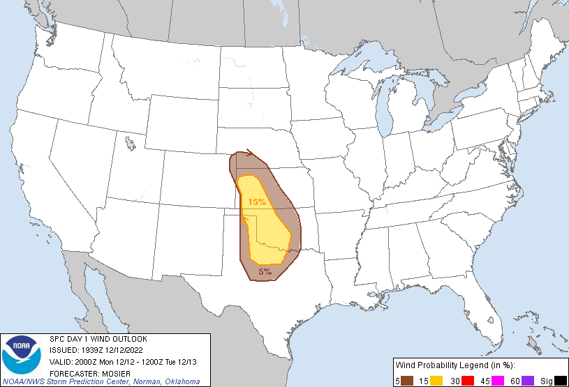
Day 1 Wind Risk
Area (sq. mi.)
Area Pop.
Some Larger Population Centers in Risk Area
15 %
75,911
2,180,197
Oklahoma City, OK...Norman, OK...Wichita Falls, TX...Lawton, OK...Edmond, OK...
5 %
84,147
4,655,866
Fort Worth, TX...Wichita, KS...Abilene, TX...Denton, TX...Lewisville, TX...
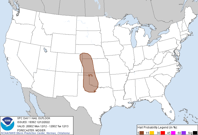
Probabilistic Large Hail Graphic
Probability of hail 1" or larger within 25 miles of a point. Hatched Area: 10% or greater probability of hail 2" or larger within 25 miles of a point.
Day 1 Hail Risk
Area (sq. mi.)
Area Pop.
Some Larger Population Centers in Risk Area
5 %
97,150
1,085,653
Wichita Falls, TX...Lawton, OK...Garden City, KS...Dodge City, KS...North Platte, NE...
   SPC AC 121939

   Day 1 Convective Outlook
   NWS Storm Prediction Center Norman OK
   0139 PM CST Mon Dec 12 2022

   Valid 122000Z - 131200Z

   ...THERE IS A SLIGHT RISK OF SEVERE THUNDERSTORMS TONIGHT FROM
   WESTERN KS SOUTHWARD ACROSS WESTERN OK AND INTO WESTERN NORTH TX...

   ...SUMMARY...
   Occasional damaging winds, isolated large hail, and a couple of
   tornadoes will be possible tonight from western Kansas across
   western/central Oklahoma into northwest Texas.

   ...20Z Update...
   Forecast outlined in the previous outlook remains valid. Rapid
   thunderstorm development is anticipated tonight around 04Z-06Z from
   western KS southward into the eastern TX Panhandle. Low-level
   moisture will be limited but modest buoyancy is still anticipated
   given cold mid-level temperatures and resulting steep mid-level
   lapse rates. An initial discrete/supercell mode is possible for an
   hour or two before the mode then trends more linear. All severe
   hazards are possible with this initially discrete mode. Strong
   ascent, and close storm proximity is expected to foster a quick
   transition to a linear mode. Intense wind fields will result in fast
   storm motion, robust vertical shear, and large hodographs. As such,
   storms capable of damaging wind gusts and embedded tornadoes are
   possible. Modest thermodynamics are currently expected to preclude
   more widespread severe potential.

   ..Mosier.. 12/12/2022

   .PREV DISCUSSION... /ISSUED 1012 AM CST Mon Dec 12 2022/

   ...KS/OK/Northwest TX...
   Morning water vapor imagery shows a broad upper trough rotating
   eastward across the western states, with an intense 100+ knot
   mid-level jet max moving into northwest Mexico.  This jet will nose
   into the high plains of eastern NM/CO and western TX/OK/KS tonight.
   Ahead of the trough, surface dewpoints in the 50s will spread into
   much of KS/OK/TX, with 60s as far north as the Red River.  This will
   lead to rapid thunderstorm development after dark.

   By early evening, the surface dryline is forecast to extend from
   near AMA northward to west of GLD.  Strong large scale forcing
   associated with the approaching upper jet will overspread the
   dryline after 03z, leading to rapid convective development.  Initial
   storms will be in limited low-level moisture, but cold temperatures
   aloft and steep lapse rates may be sufficient for a few intense
   storms capable of isolated severe hail/wind and perhaps a tornado or
   two.  As the evening progresses and the low-level jet intensifies to
   50+ knots, the storms along the dryline will become more
   widespread/organized.  Linear convective structures capable of
   damaging wind gusts and embedded, brief tornadoes are expected.
   This activity will track eastward across much of
   western/south-central OK and western North TX through 12z Tuesday
   morning.

   CLICK TO GET WUUS01 PTSDY1 PRODUCT

   NOTE: THE NEXT DAY 1 OUTLOOK IS SCHEDULED BY 0100Z