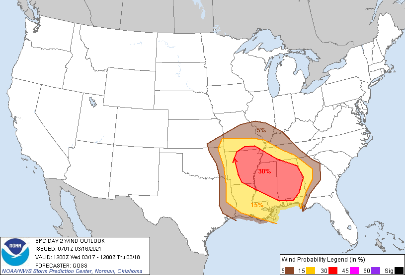
Probability of damaging thunderstorm winds or wind gusts of 50 knots or higher within 25 miles of a point. Hatched Area: 10% of greater probability of wind gusts 65 knots or greater within 25 miles of a point.
Day 2 Wind Risk
Area (sq. mi.)
Area Pop.
Some Larger Population Centers in Risk Area
30 %
126,311
8,989,924
Memphis, TN...Birmingham, AL...Montgomery, AL...Little Rock, AR...Jackson, MS...
15 %
159,606
16,705,685
New Orleans, LA...Atlanta, GA...Baton Rouge, LA...Shreveport, LA...Mobile, AL...
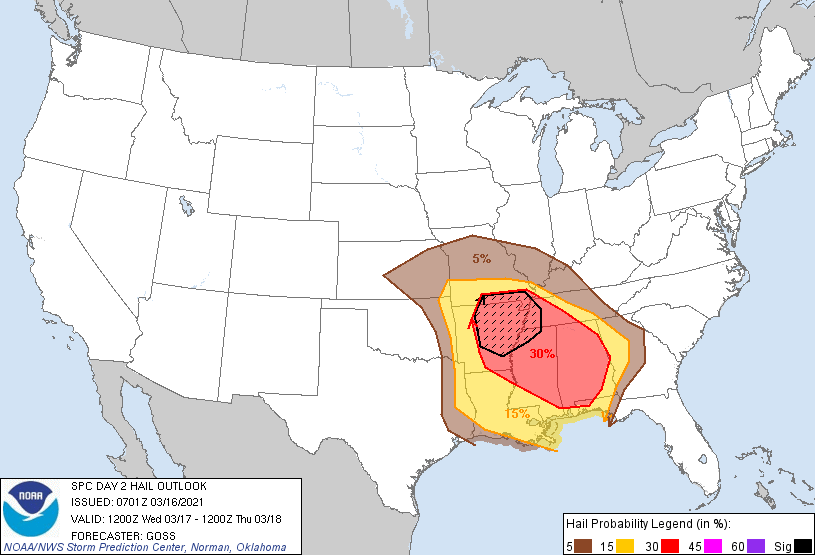
Probability of hail 1" or larger within 25 miles of a point. Hatched Area: 10% or greater probability of hail 2" or larger within 25 miles of a point.
Day 2 Hail Risk
Area (sq. mi.)
Area Pop.
Some Larger Population Centers in Risk Area
SIG SEVERE
41,676
3,269,995
Memphis, TN...Little Rock, AR...North Little Rock, AR...Jonesboro, AR...Pine Bluff, AR...
30 %
141,101
9,994,299
Memphis, TN...Birmingham, AL...Montgomery, AL...Little Rock, AR...Jackson, MS...
15 %
144,712
15,700,475
New Orleans, LA...Atlanta, GA...Baton Rouge, LA...Shreveport, LA...Mobile, AL...
5 %
154,090
16,446,548
Nashville, TN...Kansas City, MO...Tulsa, OK...Wichita, KS...St. Louis, MO...
SPC AC 160701
Day 2 Convective Outlook CORR 2
NWS Storm Prediction Center Norman OK
0201 AM CDT Tue Mar 16 2021
Valid 171200Z - 181200Z
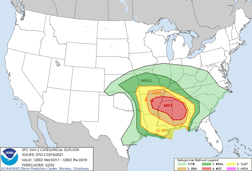
...THERE IS A MODERATE RISK OF SEVERE THUNDERSTORMS FROM
EAST-CENTRAL ARKANSAS AND SOUTHWESTERN TENNESSEE INTO NORTHERN AND
EASTERN MISSISSIPPI AND MUCH OF ALABAMA...
CORRECTED TO ADJUST LOCATION OF MRGL LABEL
...SUMMARY...
A broad area of substantial severe weather potential -- including
risk for large hail, damaging winds, and several strong tornadoes --
is anticipated Wednesday from the Arkansas/Louisiana vicinity
eastward across the central Gulf Coast states/southern Appalachians.
...Synopsis...
A compact/vigorous upper low initially over the Oklahoma area is
forecast to move steadily eastward through the period, spreading
strong flow aloft and a broad zone of enhanced ascent across the
south-central and into the southeastern CONUS. This low will reach
the Ozarks overnight, flanked by ridging across the Rockies, and
along the East Coast.
At the surface, a 998 mb low is progged to advance eastward along a
similar track, crossing northern Oklahoma/southern Kansas through
the day, and then the Ozarks overnight. A trailing cold front will
shift from eastern portions of the southern Plains and across
Arkansas/Louisiana through the afternoon, and then across the
Tennessee Valley and central Gulf Coast states through the end of
the period. Meanwhile, a warm front extending eastward from the low
across northern Arkansas/southern Missouri and then
east-southeastward across the Tennessee Valley into Georgia will
linger in place on its eastern fringe, but will lift slowly
northward in advance of the progressing low. These two fronts will
outline a broad/moist warm sector, which will gradually destabilize
through the day supporting a widespread/potentially significant
severe weather event.
...Southern MO/AR/LA vicinity east to the TN valley/western GA...
Scattered showers and thunderstorms are forecast to be ongoing ahead
of the cold front from eastern Oklahoma/western Arkansas southward
into east Texas, and east-southeastward along the warm front across
the Tennessee Valley area to the southern Appalachians.
As the synoptic system advances, convection over the central Gulf
Coast region/Southeast should remain generally north of the warm
front, while some decrease in pre-cold-frontal convection is also
expected through the morning. This should permit some heating of
the moist (generally mid 60s dewpoints) warm-sector boundary layer,
pushing mixed-layer CAPE values into the 1000 to 2000 J/kg range by
early afternoon.
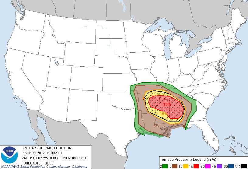
New storm development is expected to occur from the southwestern
Missouri vicinity southward across the Arklatex region by early
afternoon. Strong shear -- including veering of the wind field with
height from southerly to southwesterly -- will support ready
evolution of rotating updrafts, with some long-lived storms likely
evolving with time. Along with large hail potential, locally
damaging winds will be possible, along with a steadily increasing
tornado risk through the afternoon. As storms move into central and
eastern Arkansas, at least a few intense supercells are expected,
within the broader area of storms. Potential for a couple of
significant tornadoes is apparent, with this risk spreading into
southwestern Tennessee and northern Mississippi with either
pre-cold-frontal storms moving eastward into the region, or with
other cells developing in a zone of increasing low-level warm
advection in the warm sector/near the warm front.
During the evening and into the overnight hours, substantial
strengthening of the low-level southerlies across the central Gulf
Coast region is expected. While some diurnal decrease in
instability is expected, this should be more than offset by the
increasing low-level and deep-layer shear. As such, risk for
additional/significant tornadoes is anticipated to last through the
overnight hours, focused particularly across much of Alabama. Hail
and relatively widespread damaging winds will also be possible
across this same region.
..Goss.. 03/16/2021
CLICK TO GET WUUS02 PTSDY2 PRODUCT
NOTE: THE NEXT DAY 2 OUTLOOK IS SCHEDULED BY 1730Z