Probability of damaging thunderstorm winds or wind gusts of 50 knots or higher within 25 miles of a point. Hatched Area: 10% of greater probability of wind gusts 65 knots or greater within 25 miles of a point.
SPC AC 101618
Day 1 Convective Outlook
NWS Storm Prediction Center Norman OK
1018 AM CST Fri Dec 10 2021
Valid 101630Z - 111200Z
...THERE IS A MODERATE RISK OF SEVERE THUNDERSTORMS THIS EVENING
INTO TONIGHT FROM NORTHEAST AR/SOUTHEAST MO INTO WESTERN TN/KY AND
SOUTHERN IL...
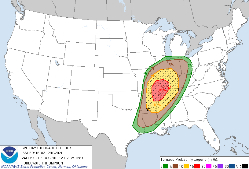
...SUMMARY...
A few strong tornadoes, damaging gusts, and large hail are all
expected beginning this evening across Arkansas and Missouri, with
the greatest tornado threat close to the confluence of the
Mississippi and Ohio Rivers. The damaging wind and tornado threat
will persist overnight while spreading eastward into the Tennessee
Valley and northeastward across the Ohio Valley overnight.
...AR/MO this evening to TN/OH Valleys overnight...
A broad midlevel trough approaching the High Plains this morning
will continue eastward to the mid MS Valley overnight. The midlevel
trough is preceded by a remnant lee cyclone that will develop from
KS today to northern MO this evening, with more substantial
deepening overnight toward Lower MI. The surface warm sector will
spread northeastward from I-40 in eastern OK/AR to I-70 in MO/IL by
this evening, with additional expansion of the warm sector into
TN/KY/IN/OH through late tonight. Regional 12z soundings revealed
65-70 F boundary-layer dewpoints in the warm sector this morning,
beneath midlevel lapse rates close to 7.5 C/km. Surface heating in
cloud breaks and continued warm/moist advection through the day will
result in destabilization and weakening of convective inhibition in
the open warm sector and along the cold front by this evening, when
storm initiation is expected.
Deep-layer southwesterly winds will be strong with long hodographs
and some low-level, clockwise curvature in the warm sector
(effective bulk shear in excess of 70 kt and effective SRH in excess
of 300 m2/s2). MLCAPE of 1000-2000 J/kg, combined with the strong
vertical shear, will favor supercells capable of producing a few
strong tornadoes and large hail initially, with increasing storm
coverage and a greater threat for damaging winds overnight (in
addition to a continued tornado threat). A lead shortwave trough
now over the TX South Plains will likely provide the impetus for at
least widely scattered storm development in the open warm sector
from AR into MO by 21-00z, with storms expected increase in coverage
(both along and ahead of the cold front) and move rapidly
northeastward to the OH and TN Valleys overnight.
..Thompson/Mosier.. 12/10/2021
CLICK TO GET WUUS01 PTSDY1 PRODUCT
NOTE: THE NEXT DAY 1 OUTLOOK IS SCHEDULED BY 2000Z