Chicago, IL...Milwaukee, WI...Kansas City, MO...Tulsa, OK...Minneapolis, MN...
Probabilistic Tornado Graphic
Probability of a tornado within 25 miles of a point. Hatched Area: 10% or greater probability of EF2 - EF5 tornadoes within 25 miles of a point.
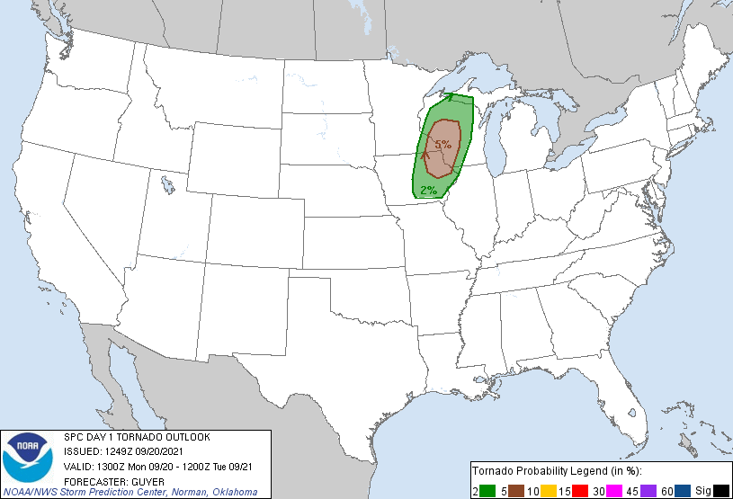
Day 1 Tornado Risk
Area (sq. mi.)
Area Pop.
Some Larger Population Centers in Risk Area
5 %
25,627
1,526,184
Cedar Rapids, IA...Waterloo, IA...Eau Claire, WI...Dubuque, IA...La Crosse, WI...
2 %
45,594
2,363,088
Madison, WI...Des Moines, IA...Rochester, MN...Iowa City, IA...Ames, IA...
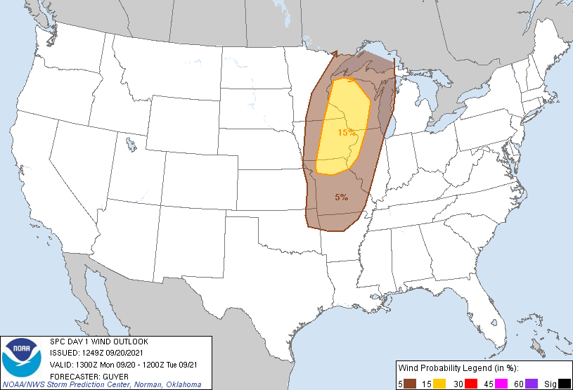
Probabilistic Damaging Wind Graphic
Probability of damaging thunderstorm winds or wind gusts of 50 knots or higher within 25 miles of a point. Hatched Area: 10% of greater probability of wind gusts 65 knots or greater within 25 miles of a point.
Chicago, IL...Milwaukee, WI...Kansas City, MO...Minneapolis, MN...St. Louis, MO...
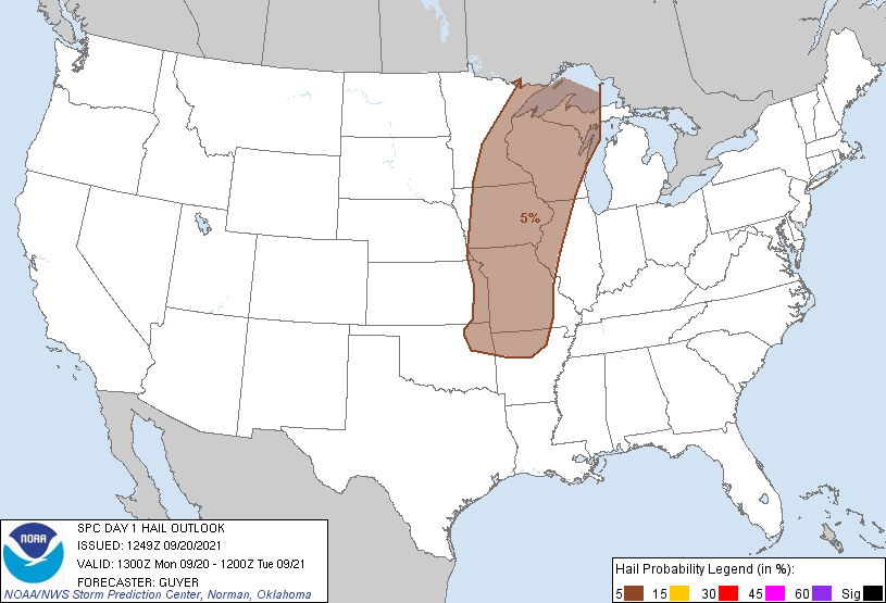
Probabilistic Large Hail Graphic
Probability of hail 1" or larger within 25 miles of a point. Hatched Area: 10% or greater probability of hail 2" or larger within 25 miles of a point.
Day 1 Hail Risk
Area (sq. mi.)
Area Pop.
Some Larger Population Centers in Risk Area
5 %
276,375
19,458,800
Kansas City, MO...Tulsa, OK...Minneapolis, MN...St. Paul, MN...Madison, WI...
SPC AC 201249
Day 1 Convective Outlook
NWS Storm Prediction Center Norman OK
0749 AM CDT Mon Sep 20 2021
Valid 201300Z - 211200Z
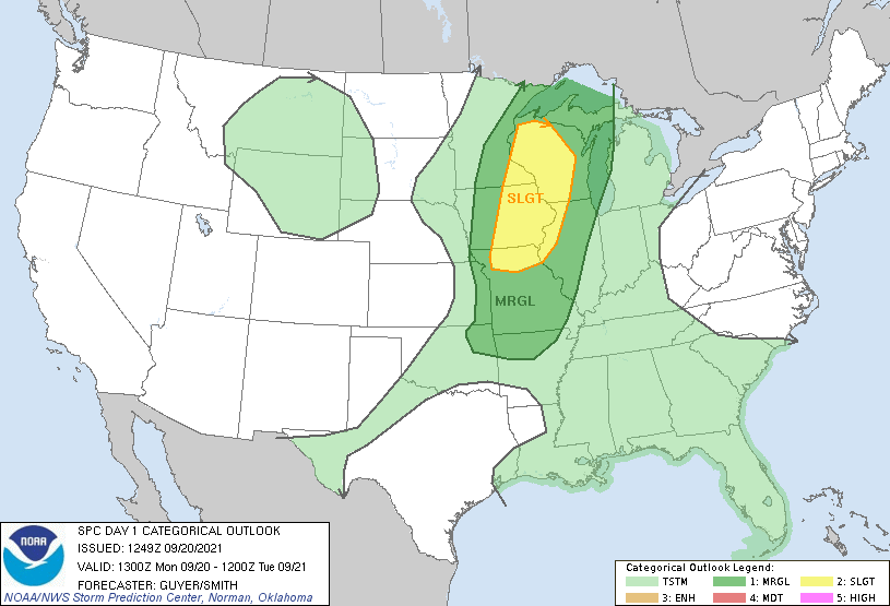
...THERE IS A SLIGHT RISK OF SEVERE THUNDERSTORMS ACROSS THE UPPER
MIDWEST...
...SUMMARY...
Isolated severe thunderstorms are expected across parts of the Upper
Mississippi Valley and Upper Great Lakes southward to the Ozark
Plateau this afternoon and evening.
...Upper Midwest/Upper Great Lakes to Ozarks...
DPVA/height falls will influence the Upper Midwest via the continued
eastward progression of a prominent late-summer trough that is
centered over the northern High Plains and Canadian Prairies early
today. Attendant to the upper trough, a strengthening of
cyclonically curved westerlies aloft will occur especially this
afternoon through tonight, focused near/behind an
east/southeastward-advancing cold front.
Scattered showers and thunderstorms are prevalent this morning near
the front and up to about 100-150 miles ahead (east) of it, and the
potential lingering influence of this activity may effectively
spatially influence downstream convective intensification this
afternoon via outflow/differential heating. Particularly given the
pre-frontal cloud debris and residual precipitation, relatively
modest destabilization (perhaps up to 1000-1250 J/kg MLCAPE) is
expected this afternoon across southeast Minnesota and much of
Wisconsin, with moderately stronger destabilization (up to 2000 J/kg
MLCAPE) expected across eastern Iowa/northern Missouri/far western
Illinois.
As the pre-frontal boundary layer warms, convective intensification
appears most likely to initially occur across central/northeast Iowa
and northwest Missouri northeastward into southeast Minnesota and
far western Wisconsin by around mid-afternoon (circa 20-21Z). While
the strongest winds aloft/vertical shear will tend to lag the
east/southeast-moving front, stronger deep-layer winds will extend
somewhat (eastward) into the warm sector across Iowa into eastern
Minnesota and Wisconsin, where some low-level southeasterly backing
of surface winds may also occur given relative proximity to the
frontal wave/surface low.
Some initial supercells are possible especially within the
aforementioned corridor, while the influence of the cold front and
front-parallel vertical shear otherwise leads to a prevalence of
linear bands/clusters including some bowing segments. Some initial
severe hail is possible, but damaging winds should become the more
common severe risk through the evening. Some tornado risk will also
exist as well via a mixed storm mode, including a QLCS-related
tornado potential. Overall storm intensity is likely to wane into
the late evening and overnight hours as boundary-layer convective
inhibition nocturnally increases.
..Guyer/Smith.. 09/20/2021
CLICK TO GET WUUS01 PTSDY1 PRODUCT
NOTE: THE NEXT DAY 1 OUTLOOK IS SCHEDULED BY 1630Z