Probability of damaging thunderstorm winds or wind gusts of 50 knots or higher within 25 miles of a point. Hatched Area: 10% of greater probability of wind gusts 65 knots or greater within 25 miles of a point.
Charlotte, NC...Kansas City, MO...Atlanta, GA...Omaha, NE...Lincoln, NE...
Probabilistic Large Hail Graphic
Probability of hail 1" or larger within 25 miles of a point. Hatched Area: 10% or greater probability of hail 2" or larger within 25 miles of a point.
Day 1 Hail Risk
Area (sq. mi.)
Area Pop.
Some Larger Population Centers in Risk Area
5 %
111,144
7,300,442
Kansas City, MO...Omaha, NE...Lincoln, NE...Des Moines, IA...Overland Park, KS...
SPC AC 310534
Day 1 Convective Outlook
NWS Storm Prediction Center Norman OK
1234 AM CDT Tue Aug 31 2021
Valid 311200Z - 011200Z
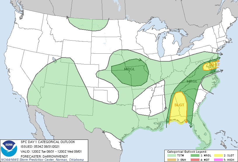
...THERE IS A SLIGHT RISK OF SEVERE THUNDERSTORMS ACROSS PARTS OF
THE GULF STATES AND OVER PARTS OF THE MIDDLE ATLANTIC...
...SUMMARY...
A few tornadoes associated with Ida will be possible Tuesday from
parts of the Florida Panhandle to the southern Appalachians.
Isolated strong storms may also be noted across portions of the
middle Atlantic.
...Remnants of Ida...
Remnants of Ida are lifting slowly northeast across northern MS
early this morning. Center of circulation is forecast to advance
across northern AL, then into eastern TN by the end of the period.
Tropical-moisture plume associated with Ida should gradually advance
east across the Gulf States/southern Appalachians as stronger flow
spreads downstream with the remnant low. While strongest low-level
shear will spread across the southern Appalachians, stronger
buoyancy will be noted farther south and this is where more robust
updrafts are expected. Earlier thoughts regarding the tornado
potential continue, though higher tornado probabilities have been
adjusted a bit east to account for recent trends and forecast
convective bands.
...Middle Atlantic...
Westerly mid-level flow is forecast to increase a bit across the
middle Atlantic today as the height field tightens in response Ida.
Low-level confluence zone is expected to be draped across the
Delmarva and this should serve as the primary corridor for
potentially strong convection later today. High-PW air mass and
modest westerly flow through a deep layer suggest isolated severe
wind gusts are the primary risk.
...Lower MO Valley...
A conglomeration of thunderstorms is evolving along a corridor from
central South Dakota-northeast NE-central IA early this morning.
Southwesterly LLJ is focused across central NE into this activity
and further expansion is expected prior to sunrise as this corridor
of storms propagates southeast toward the lower MO Valley. It's not
entirely clear where this MCS will be at the start of the day1
period, but convective outflow and the potential to disrupt the
downstream air mass will prove instrumental in potential severe
development later today. Have expanded MRGL Risk to include a
greater region of the lower MO Valley but northwesterly flow may
allow this convection to ultimately spread farther downstream than
currently depicted in latest model guidance. If it becomes more
clear focused convection will evolve within a modest-instability air
mass then severe probabilities may need to be increased. This can be
addressed in later outlooks.
..Darrow/Wendt.. 08/31/2021
CLICK TO GET WUUS01 PTSDY1 PRODUCT
NOTE: THE NEXT DAY 1 OUTLOOK IS SCHEDULED BY 1300Z