Probability of damaging thunderstorm winds or wind gusts of 50 knots or higher within 25 miles of a point. Hatched Area: 10% of greater probability of wind gusts 65 knots or greater within 25 miles of a point.
Probability of hail 1" or larger within 25 miles of a point. Hatched Area: 10% or greater probability of hail 2" or larger within 25 miles of a point.
Day 1 Hail Risk
Area (sq. mi.)
Area Pop.
Some Larger Population Centers in Risk Area
SIG SEVERE
37,788
1,431,566
Duluth, MN...Eau Claire, WI...Wausau, WI...Superior, WI...Stevens Point, WI...
30 %
28,282
1,025,242
Duluth, MN...Eau Claire, WI...Wausau, WI...Superior, WI...Stevens Point, WI...
15 %
70,661
8,450,377
Milwaukee, WI...Minneapolis, MN...St. Paul, MN...Madison, WI...Green Bay, WI...
5 %
125,338
28,423,715
Chicago, IL...Baltimore, MD...Washington, DC...Virginia Beach, VA...Norfolk, VA...
SPC AC 282000
Day 1 Convective Outlook
NWS Storm Prediction Center Norman OK
0300 PM CDT Wed Jul 28 2021
Valid 282000Z - 291200Z
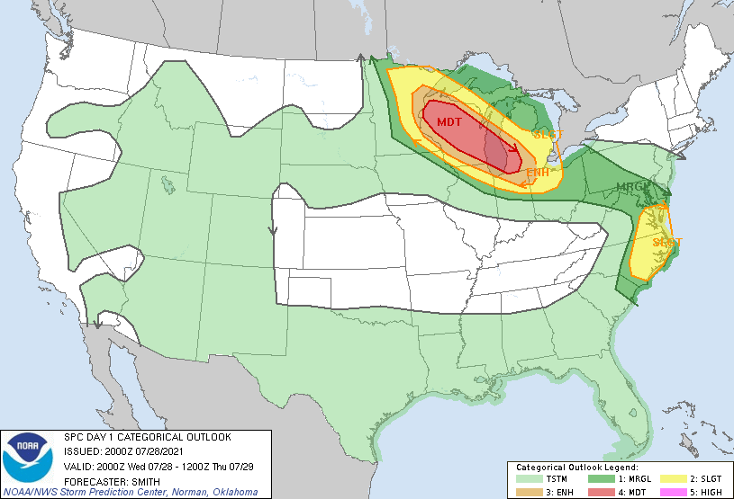
...THERE IS A MODERATE RISK OF SEVERE THUNDERSTORMS
WISCONSIN...SOUTHERN HALF OF LAKE MICHIGAN...SOUTHWEST LOWER
MICHIGAN...
...THERE IS A SLIGHT RISK OF SEVERE THUNDERSTORMS SOUTHEAST
VIRGINIA...EASTERN NORTH CAROLINA...
...SUMMARY...
Potentially widespread severe thunderstorms are expected late this
afternoon through tonight along a corridor from northeastern
Minnesota across Wisconsin into southwest Lower Michigan. A few
severe storms are also expected this afternoon over parts of
Virginia and North Carolina.
...Discussion...
The only change this outlook update is to upgrade severe-wind
probabilities from the southern half of Lake Michigan southeastward
into northwest OH. Recent runs of the HRRR indicate an intense rear
inflow jet late tonight as a bow moves southeastward across Lake
Michigan into the Michiana vicinity. Confidence in a widespread
severe-gust threat has increased and is depicted in the minor nudges
upwards in probabilities.
..Smith.. 07/28/2021
.PREV DISCUSSION... /ISSUED 1114 AM CDT Wed Jul 28 2021/
...Upper Midwest...
Strong west/northwesterly mid-level winds stretch from southern
Canada into the Great Lakes region today, with several embedded
shortwave troughs and jet maxima. One of these features currently
over ND/MB will track southeastward into MN this afternoon. Morning
clouds and scattered convection has limited heating thus far across
MN, but at least pockets of afternoon destabilization will result in
MLCAPE values of 1500-2500 J/kg. Most 12z guidance suggests that
the ongoing convection will not significantly impact the development
of afternoon thunderstorms across northern MN, where effective shear
values of 45-55 knots and large hodographs will promote supercell
structures and the potential for very large hail and a few
tornadoes. Storms are expected to race southeastward through the
evening across northern/central WI, and into southern WI/southern
LM/southwest Lower MI overnight. The primary severe concern is if
storms congeal into a bowing complex, widespread and potentially
significant wind damage will be possible. Most guidance suggests
the MCS will weaken late tonight as it moves into a slightly less
moist/unstable air mass over MI/IN/OH. However, if mesoscale
organization is sufficiently high, the complex could persist longer
than model depictions.
...VA/NC...
Clear skies are present today from the Tidewater region of VA into
northeast and central NC. This area is very moist/unstable with
dewpoints in the mid 70s and 500mb temperatures cooling slightly
through the day. Rather widespread thunderstorms are expected today
in this region, with sufficient for organized multicell storm
clusters, or even a transient supercell or two. Damaging winds may
occur in the stronger cells. Therefore have added a SLGT risk to
this region.
CLICK TO GET WUUS01 PTSDY1 PRODUCT
NOTE: THE NEXT DAY 1 OUTLOOK IS SCHEDULED BY 0100Z