Probability of damaging thunderstorm winds or wind gusts of 50 knots or higher within 25 miles of a point. Hatched Area: 10% of greater probability of wind gusts 65 knots or greater within 25 miles of a point.
Day 1 Wind Risk
Area (sq. mi.)
Area Pop.
Some Larger Population Centers in Risk Area
15 %
23,447
193,680
Rapid City, SD...Spearfish, SD...Rapid Valley, SD...Sturgis, SD...Belle Fourche, SD...
5 %
319,648
21,558,142
Milwaukee, WI...Denver, CO...Miami, FL...Colorado Springs, CO...Aurora, CO...
Probabilistic Large Hail Graphic
Probability of hail 1" or larger within 25 miles of a point. Hatched Area: 10% or greater probability of hail 2" or larger within 25 miles of a point.
Day 1 Hail Risk
Area (sq. mi.)
Area Pop.
Some Larger Population Centers in Risk Area
15 %
18,351
151,119
Rapid City, SD...Spearfish, SD...Sturgis, SD...Belle Fourche, SD...
5 %
203,016
5,097,197
Milwaukee, WI...Madison, WI...Green Bay, WI...Appleton, WI...Waukesha, WI...
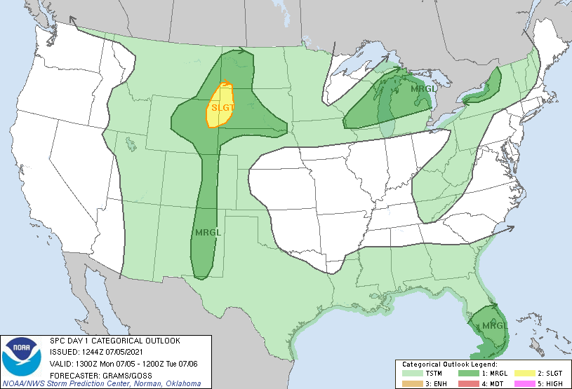
   SPC AC 051244

   Day 1 Convective Outlook
   NWS Storm Prediction Center Norman OK
   0744 AM CDT Mon Jul 05 2021

   Valid 051300Z - 061200Z

   ...THERE IS A SLIGHT RISK OF SEVERE THUNDERSTORMS BLACK HILLS
   VICINITY...

   ...SUMMARY...
   Isolated severe thunderstorms are possible from the northern Great
   Plains to the southern High Plains, across the Great Lakes, and in
   south Florida.

   ...Northern Great Plains...
   A low-amplitude shortwave impulse near the ID/MT/WY border will
   progress east into the northern Great Plains through tonight. A
   separate lead MCV which has aided early morning convection in
   western SD should drift east. Scattered thunderstorm development is
   expected along a quasi-stationary frontal zone in southeast SD
   west-northwest to a north/south-oriented lee trough across far
   eastern MT/WY.

   Larger buoyancy will generally be confined to a narrow corridor
   along the south side of the surface front from the Mid-MO Valley
   eastward where mid 60s surface dew points remain prevalent. More
   muted buoyancy is expected farther west in the MT/WY/Dakotas border
   region, but should reach 500-1500 J/kg. Deep-layer shear profiles
   will generally remain modest, but should be slightly enhanced within
   a confined west/east-oriented corridor ahead of the latter mid-level
   impulse. This may support a slightly greater severe threat in the
   Black Hills vicinity. Otherwise, the overall setup should favor
   multicell clustering with isolated severe wind and hail as the
   primary hazards through about dusk.

   ...Great Lakes...
   A shortwave trough from north-central Ontario to the northern Great
   Lakes should reach the Saint Lawrence Valley tonight. Morning
   convection is ongoing within the warm conveyor region attendant to
   this trough across parts of Upper MI. Multiple convective scenarios
   are possible today. Ongoing convection may eventually become
   surface-based across northern Lower MI before existing into southern
   Ontario and perhaps spreading east into western NY tonight. The more
   likely scenario is for upstream late afternoon development to occur
   as the trailing surface cold front reaches the east-central WI
   vicinity. Upper-level winds will remain weak, but a swath of 30-40
   kt 700-mb westerlies east of Lake MI renders concern for potential
   multicell clustering in Lower MI. However, CAM guidance is not
   particularly robust with convective signals as orientation of
   development largely parallels the low to mid-level flow regime.
   Confidence is too low to yet highlight a corridor of greater
   damaging wind threat.

   ...South FL...
   Pulse to weak multicell clusters should develop north this afternoon
   within outer convective bands associated with TC Elsa, along the
   leading edge of strengthening low-level southeasterlies. This
   activity may pose a threat for wet microbursts producing locally
   damaging winds.

   Tonight, low-level hodograph curvature should begin to enlarge,
   mainly across the Keys and the far southern portion of the
   Peninsula. It seems most likely that SRH will remain tempered
   through 12Z, but adequate for a low-probability tornado threat.

   ...Southern High Plains...
   An MCS that swept south overnight, the remnants of which are
   decaying over the Permian Basin, should largely relegate late
   afternoon severe potential to a north/south-oriented corridor in
   eastern NM. A persistent belt of confluent mid-level northerlies
   could aid in a couple updrafts capable of isolated, marginally
   severe hail and wind that develop off the higher terrain.

   ..Grams/Goss.. 07/05/2021

   CLICK TO GET WUUS01 PTSDY1 PRODUCT

   NOTE: THE NEXT DAY 1 OUTLOOK IS SCHEDULED BY 1630Z