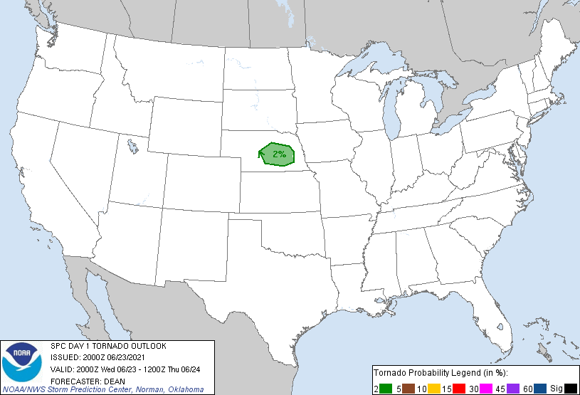
Des Moines, IA...Billings, MT...Fargo, ND...Sioux City, IA...St. Joseph, MO...
Probabilistic Tornado Graphic
Probability of a tornado within 25 miles of a point. Hatched Area: 10% or greater probability of EF2 - EF5 tornadoes within 25 miles of a point.
Day 1 Tornado Risk
Area (sq. mi.)
Area Pop.
Some Larger Population Centers in Risk Area
2 %
15,039
296,683
Grand Island, NE...Kearney, NE...Hastings, NE...Columbus, NE...Lexington, NE...
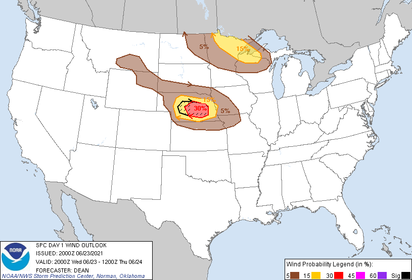
Probabilistic Damaging Wind Graphic
Probability of damaging thunderstorm winds or wind gusts of 50 knots or higher within 25 miles of a point. Hatched Area: 10% of greater probability of wind gusts 65 knots or greater within 25 miles of a point.
Day 1 Wind Risk
Area (sq. mi.)
Area Pop.
Some Larger Population Centers in Risk Area
SIG SEVERE
19,512
347,843
Grand Island, NE...Kearney, NE...North Platte, NE...Hastings, NE...Columbus, NE...
30 %
14,406
292,418
Grand Island, NE...Kearney, NE...Hastings, NE...Columbus, NE...
Des Moines, IA...Billings, MT...Fargo, ND...Sioux City, IA...St. Joseph, MO...
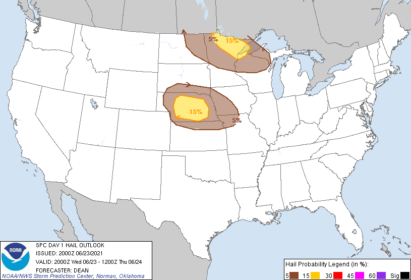
Probabilistic Large Hail Graphic
Probability of hail 1" or larger within 25 miles of a point. Hatched Area: 10% or greater probability of hail 2" or larger within 25 miles of a point.
Day 1 Hail Risk
Area (sq. mi.)
Area Pop.
Some Larger Population Centers in Risk Area
15 %
64,359
873,307
Duluth, MN...Grand Island, NE...Kearney, NE...Superior, WI...North Platte, NE...
5 %
186,967
5,983,631
Omaha, NE...Lincoln, NE...Des Moines, IA...Fargo, ND...Sioux City, IA...
SPC AC 232000
Day 1 Convective Outlook
NWS Storm Prediction Center Norman OK
0300 PM CDT Wed Jun 23 2021
Valid 232000Z - 241200Z
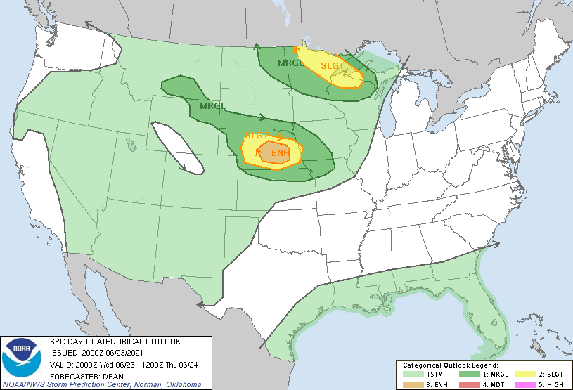
...THERE IS AN ENHANCED RISK OF SEVERE THUNDERSTORMS THIS EVENING
ACROSS CENTRAL NEBRASKA...
...THERE IS A SLIGHT RISK OF SEVERE THUNDERSTORMS FROM NORTHERN
MN/WI INTO THE WESTERN U.P. OF MI...
...SUMMARY...
Strong to severe storms are expected late this afternoon into
tonight across parts of the central Plains and Upper Midwest.
Damaging winds and large hail should be the main threats, with the
greatest damaging wind threat expected across central Nebraska
tonight.
...Nebraska and vicinity...
The primary change for the 20Z outlook is to add a 10% significant
wind area across portions of central NE. Development of a bowing
complex still looks possible this evening, which would pose a threat
of at least isolated significant (greater than 65 kt) wind gusts
within a corridor of potentially damaging wind. The Marginal Risk
has also been expanded somewhat to the north and east across
southeast SD and western IA, in deference to some CAM guidance which
suggests vigorous development is possible later tonight in these
areas.
..Northern MN/WI...
No changes have been made to this area. Widely scattered strong
thunderstorms still appear possible by late afternoon along a cold
front, and later tonight within a warm advection regime, posing a
threat of large hail and damaging wind as convection spreads
southeastward.
..Dean.. 06/23/2021
.PREV DISCUSSION... /ISSUED 1256 PM CDT Wed Jun 23 2021/
...NE and vicinity...
Morning water vapor loop shows an upper ridge over the central High
Plains region. Model guidance indicates that midlevel heights will
continue to rise across this area through mid-afternoon, until a
weak shortwave trough over WY/CO tops the ridge and begins to move
into western NE. This will be coincident with peak heating and
scattered thunderstorm development. These storms will likely become
severe by early evening and track across much of NE through the
night. Convection is expected to grow upscale during this period,
with a fast-moving bowing complex capable of damaging winds.
Therefore, have added a small ENH for this threat.
...Northern MN/WI...
A strong shortwave trough is digging southeastward across
Saskatchewan toward the northern Plains. The associated surface
cold front will sweep into ND/MN this evening, where scattered
thunderstorm development is expected. These storms will track
southeastward across northern MN through the evening, and into
northern WI overnight. Low-level moisture will be slowly recovering
in this region, with the greatest moisture/CAPE values remaining
south of the SLGT risk area. Nevertheless, a few intense cells will
be possible, capable of large hail and damaging winds.
...Southern MT into northeast WY...
Strong heating is occurring today across southern MT into northeast
WY, where dewpoints are in the 40s and afternoon MLCAPE values are
forecast to approach 1000 J/kg. Forecast soundings indicate a
deeply mixed boundary layer, along with relatively strong westerly
flow aloft. This may result in a few thunderstorms capable of
gusty/damaging winds this afternoon and early evening across the
region.
CLICK TO GET WUUS01 PTSDY1 PRODUCT
NOTE: THE NEXT DAY 1 OUTLOOK IS SCHEDULED BY 0100Z