Probability of damaging thunderstorm winds or wind gusts of 50 knots or higher within 25 miles of a point. Hatched Area: 10% of greater probability of wind gusts 65 knots or greater within 25 miles of a point.
Day 1 Wind Risk
Area (sq. mi.)
Area Pop.
Some Larger Population Centers in Risk Area
SIG SEVERE
10,038
68,472
Hays, KS...
30 %
13,799
81,814
Hays, KS...
15 %
153,008
8,462,238
New Orleans, LA...Baton Rouge, LA...Mobile, AL...Jackson, MS...Metairie, LA...
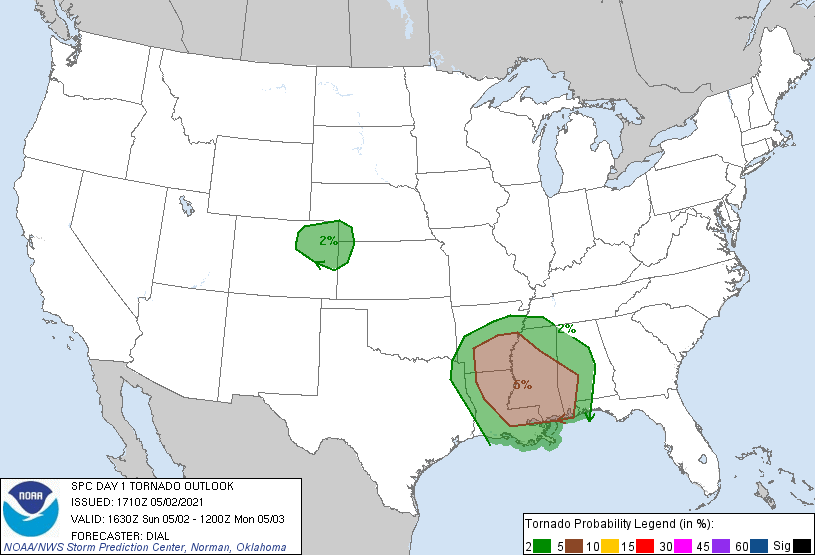
   SPC AC 021710

   Day 1 Convective Outlook CORR 1
   NWS Storm Prediction Center Norman OK
   1210 PM CDT Sun May 02 2021

   Valid 021630Z - 031200Z

   ...THERE IS AN ENHANCED RISK OF SEVERE THUNDERSTORMS OVER A PORTION
   OF NORTHERN KANSAS...

   ...THERE IS A SLIGHT RISK OF SEVERE THUNDERSTORMS OVER A PORTION OF
   THE LOWER MISSISSIPPI VALLEY...

   CORRECTED FOR THUNDER LINE IN FLORIDA

   ...SUMMARY...
   Severe storms with scattered damaging wind along with potential for
   a few significant wind gusts are expected from northeast Colorado
   into northern Kansas later this afternoon into the evening. Isolated
   severe storms remain possible this afternoon into the evening over a
   portion of the lower Mississippi Valley region.

   ...Central Plains area...

   Late this morning a cold front extends from northeast NE southwest
   through eastern CO then northwestward through northwest CO. Surface
   low is situated over southwest CO with a dryline extending southward
   through the southern High Plains. WV imagery and RAP analysis show
   the next in a series of impulses moving east through the central
   Rockies, and this feature will emerge over the High Plains this
   afternoon. Near-surface dewpoints in the generally in the 50s F
   reside in pre-frontal warm sector across northern KS and southern NE
   with 40s farther west into eastern CO beneath plume of 7.5-8 C/km
   mid-level lapse rates. Strong diabatic heating will destabilize the
   boundary layer this afternoon contributing to MLCAPE from less than
   1000 J/kg across eastern CO to 1500 J/kg across northern KS and
   southern NE. The northeasterly upslope flow in post frontal region
   will likely contribute to thunderstorm development initially across
   northern CO where a few thunderstorms are already in progress. This
   activity will intensify across northeast CO and especially northwest
   KS as the outflow/front intercepts greater low-level moisture and
   instability by mid afternoon. Easterly low-level winds veering to
   westerly and increasing to 30 kt through the mid-levels will support
   a forward propagating MCS as the downstream atmosphere destabilizes.
   Inverted-V thermodynamic profiles with steep low-mid level lapse
   rates should promote efficient downdraft production, and effective
   bulk shear up to 35 kt may support embedded organized structures
   with a corridor of scattered damaging wind likely as the MCS
   advances through northern KS.

   ...Lower Mississippi Valley region...

   Late this morning a warm front extends from the central Gulf Coast
   area through southeast LA then northwest into northwest LA to a weak
   surface low in northeast TX. A cold front extends southward from the
   low through eastern TX. Widespread clouds and precipitation has
   limited destabilization over most of this region so far. However,
   trends in visible imagery show clearing across eastern TX into far
   western LA. As the warm front continues north and clouds erode from
   the southwest, destabilization is expected to spread northeast with
   time. Ascent accompanying the primary shortwave trough now moving
   through east TX is intercepting the destabilizing warm sector with
   surface-based convection now developing from southwest TX into
   western LA. Effective bulk shear from 35-40 kt and up to 200 m2/s2
   0-2 km storm relative helicity should support some organized storm
   structures including a few supercells. All severe modes are possible
   including isolated damaging wind, large hail and a few tornadoes.
   The best tornado threat will probably be as warm sector storms move
   northeast and interact with warm front. The severe threat will
   gradually spread northeast through the remainder of the SLGT risk
   area during the afternoon and into the evening.

   ..Dial.. 05/02/2021

   CLICK TO GET WUUS01 PTSDY1 PRODUCT

   NOTE: THE NEXT DAY 1 OUTLOOK IS SCHEDULED BY 2000Z