Probability of a tornado within 25 miles of a point. Hatched Area: 10% or greater probability of EF2 - EF5 tornadoes within 25 miles of a point.
Day 1 Tornado Risk
Area (sq. mi.)
Area Pop.
Some Larger Population Centers in Risk Area
No Risk Areas Forecast
Probabilistic Damaging Wind Graphic
Probability of damaging thunderstorm winds or wind gusts of 50 knots or higher within 25 miles of a point. Hatched Area: 10% of greater probability of wind gusts 65 knots or greater within 25 miles of a point.
Day 1 Wind Risk
Area (sq. mi.)
Area Pop.
Some Larger Population Centers in Risk Area
5 %
48,827
7,202,137
San Antonio, TX...Austin, TX...Killeen, TX...Round Rock, TX...San Angelo, TX...
Probabilistic Large Hail Graphic
Probability of hail 1" or larger within 25 miles of a point. Hatched Area: 10% or greater probability of hail 2" or larger within 25 miles of a point.
Day 1 Hail Risk
Area (sq. mi.)
Area Pop.
Some Larger Population Centers in Risk Area
SIG SEVERE
46,027
4,644,197
Austin, TX...Killeen, TX...Round Rock, TX...San Angelo, TX...College Station, TX...
15 %
75,090
8,123,623
Austin, TX...Waco, TX...Abilene, TX...Killeen, TX...Round Rock, TX...
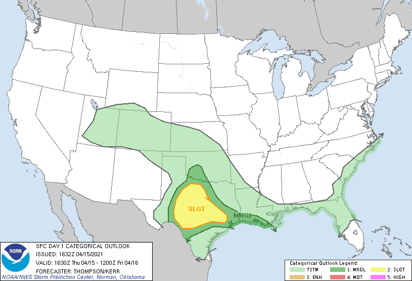
   SPC AC 151632

   Day 1 Convective Outlook
   NWS Storm Prediction Center Norman OK
   1132 AM CDT Thu Apr 15 2021

   Valid 151630Z - 161200Z

   ...THERE IS A SLIGHT RISK OF SEVERE THUNDERSTORMS THROUGH TONIGHT
   FOR CENTRAL TX...AS WELL AS PARTS OF NORTHWEST AND SOUTHEAST TX...

   ...SUMMARY...
   Isolated very large hail will be possible today with elevated
   supercells, mainly across central Texas.

   ...Southern Plains through early Friday...
   A mid-upper low over northern UT this morning will evolve into more
   of an open wave and move eastward to the central High Plains by
   early Friday.  South of the low, embedded/subtle speed maxima will
   eject eastward over TX, above a shallow cool air mass near the
   surface.  The embedded speed maxima, and associated enhancements to
   low-level warm advection, are contributing to bouts of elevated
   convection, the first of which is ongoing over central TX.  Per the
   12z DRT sounding, MUCAPE of 2000-3000 J/kg, midlevel lapse rates
   near 8 C/km, and effective bulk shear near 50 kt (with somewhat
   straight hodographs above the 850 mb level) are supporting splitting
   supercells rooted in the 850-700 mb layer.  Given the near-storm
   environment, the strongest of these supercells will be capable of
   producing hail near the size of tennis balls or baseballs, and
   perhaps a few strong gusts will reach the surface with the southern
   storms (closer to the surface front).  There will also be some
   possibility for a storm or two to persist through the afternoon from
   central toward parts of southeast TX.

   An additional round of elevated convection is expected overnight
   from northwest/north central TX into OK as warm advection increases
   in response to height falls preceding the midlevel trough
   approaching the High Plains.  This will support some additional
   northward advection of moisture atop the frontal surface, as well as
   northeastward spread of steeper midlevel lapse rates.  Similar to
   previous days, a few of these elevated storms could be supercells
   with a localized threat for large hail.

   ...North central/northeast Gulf coast today...
   The stronger convection and associated outflow have moved offshore
   this morning.  Anvil shading into the FL Big Bend, and the richer
   moisture remaining offshore across the eastern Gulf of Mexico,
   suggest that the stronger storms (and attendant severe threat) will
   likewise remain offshore.

   ..Thompson/Kerr.. 04/15/2021

   CLICK TO GET WUUS01 PTSDY1 PRODUCT

   NOTE: THE NEXT DAY 1 OUTLOOK IS SCHEDULED BY 2000Z