Virginia Beach, VA...Tampa, FL...St. Petersburg, FL...Orlando, FL...Hampton, VA...
Probabilistic Damaging Wind Graphic
Probability of damaging thunderstorm winds or wind gusts of 50 knots or higher within 25 miles of a point. Hatched Area: 10% of greater probability of wind gusts 65 knots or greater within 25 miles of a point.
Jacksonville, FL...Virginia Beach, VA...Tampa, FL...Cincinnati, OH...St. Petersburg, FL...
SPC AC 181633
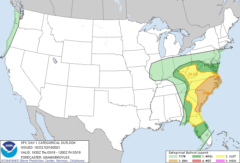
Day 1 Convective Outlook
NWS Storm Prediction Center Norman OK
1133 AM CDT Thu Mar 18 2021
Valid 181630Z - 191200Z
...THERE IS AN ENHANCED RISK OF SEVERE THUNDERSTORMS CENTERED ON THE
CENTRAL AND EASTERN CAROLINAS...
...SUMMARY...
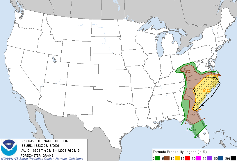
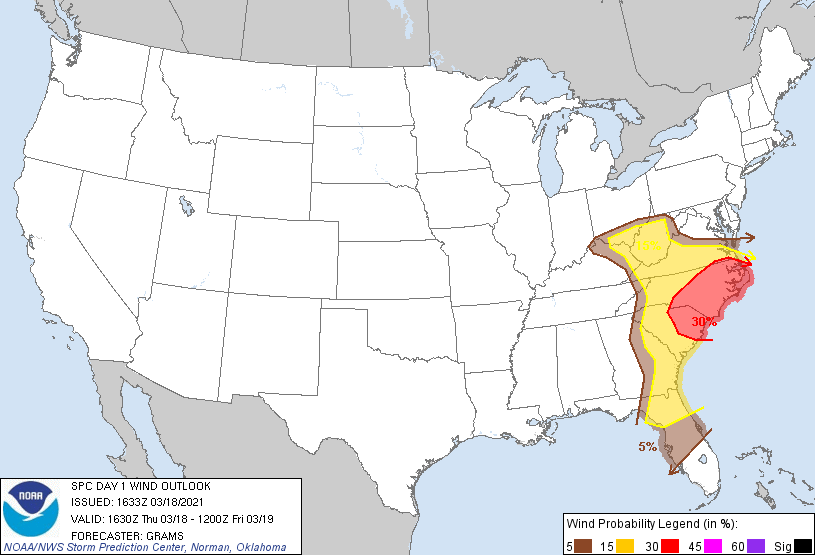
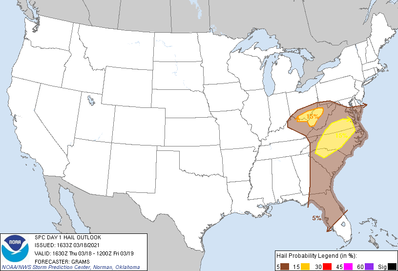
Scattered severe thunderstorms will likely be centered on the
central and eastern Carolinas. A few tornadoes (a couple of which
might be strong), damaging winds, and some hail remain possible.
Other isolated severe storms are possible from southern Ohio into
the central Appalachians, and across north Florida.
...Southeast...
Overall severe threat will likely focus in two corridors which are
encompassed by the cat 3/ENH risk for tornado and wind. Initial
broken band of non-severe convection is ongoing from south-central
GA through the eastern FL Panhandle. This activity has struggled to
intensify despite strong low to deep-layer shear as it impinges on a
relative minimum in buoyancy sampled by the 12Z JAX sounding and
evident in mesoanalysis time-series. However, destabilization is
occurring downstream from north FL to the coastal Carolinas and
redevelopment of severe storms is anticipated at some point this
afternoon. The eastward translation of a 50-55 kt LLJ will support
an enlarged hodograph favorable for a few supercells. Modest
mid-level lapse rates will remain a limiting factor, though MLCAPE
will be large enough given to support a few tornadoes and scattered
damaging winds, with a strong tornado or two still possible.
The separate area of potential severe should be coincident with the
track of a mesolow from the northeast GA/northwest SC border across
the Piedmont towards south-central VA. Here, MLCAPE will likely
remain weak but cloud breaks just ahead of the low near the
mid-level dry slot may prove sufficient for an intensifying area of
convection. Where sufficient buoyancy overlaps the more
favorable/curved hodographs east of the mountains, a couple
supercells capable of a strong tornado, damaging winds, and isolated
large hail will all be possible this afternoon/evening.
...OH Valley...
East and southeast of the weakening occluded cyclone, pockets of
stronger boundary-layer heating are underway on the nose of the
mid-level dry slot. In conjunction with cool mid-level temperatures,
500-1000 J/kg of MLCAPE will be sufficient for a few strong-severe
storms later this afternoon. This area will be on the northwest edge
of the stronger flow/shear, where a mix of multicell clusters and a
few low-end supercells are probable. A tornado or two, large hail,
and damaging winds will be possible.
..Grams/Broyles.. 03/18/2021
CLICK TO GET WUUS01 PTSDY1 PRODUCT
NOTE: THE NEXT DAY 1 OUTLOOK IS SCHEDULED BY 2000Z