Probability of damaging thunderstorm winds or wind gusts of 50 knots or higher within 25 miles of a point. Hatched Area: 10% of greater probability of wind gusts 65 knots or greater within 25 miles of a point.
SPC AC 172137
Day 1 Convective Outlook CORR 1
NWS Storm Prediction Center Norman OK
0437 PM CDT Wed Mar 17 2021
Valid 172000Z - 181200Z
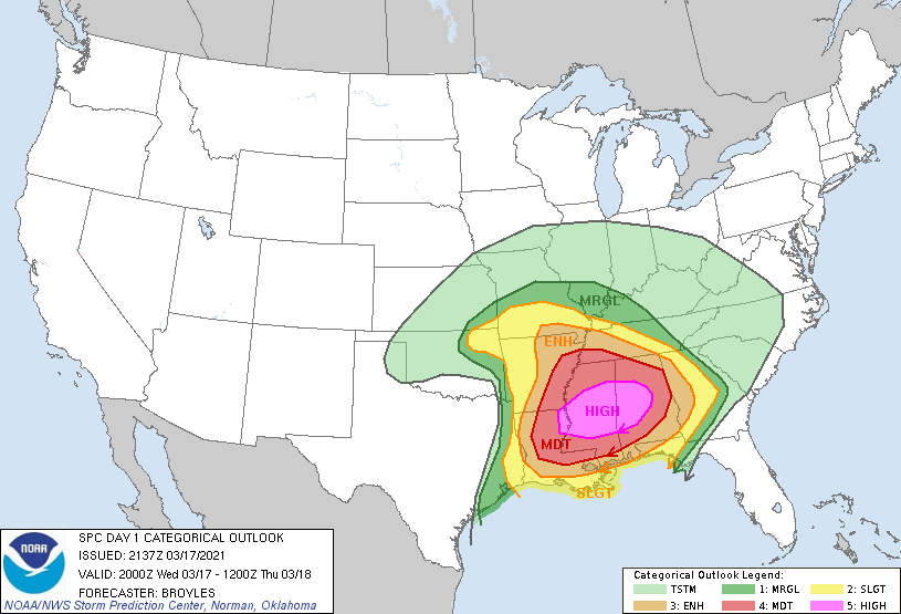
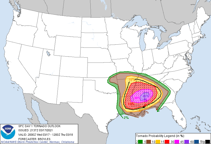
...THERE IS A HIGH RISK OF SEVERE THUNDERSTORMS ACROSS
ALABAMA...MISSISSIPPI...FAR NORTHEAST LOUISIANA AND FAR SOUTHEAST
ARKANSAS...
CORRECTED TO CHANGE I-80 TO HIGHWAY-80
...SUMMARY...
A significant tornado outbreak is expected with numerous strong and
a few long-track, potentially violent tornadoes. The initial round
will continue across Alabama this afternoon. A separate swath should
emanate from far northeast Louisiana this afternoon and spread east
across Mississippi and Alabama this evening into tonight.
...DISCUSSION...
A few changes have been made to the outlook for this issuance. The
first change is to move the High Risk area southward to include more
of south-central Mississippi and southwest Alabama. The 45 percent
contour has also been adjusted southward, to encompass the first
phase of the tornado outbreak ongoing in southwest Alabama. The
newest tornado outbreak model guidance places the greatest threat
along a corridor east-northeast from near Jackson, Mississippi
east-northeast along the Highway-80 corridor into the area to the
south of Tuscaloosa, Alabama.
The second is to extend the slight risk westward into parts of
northeast Oklahoma. Severe thunderstorms are ongoing and will spread
northward across northeast Oklahoma this afternoon. Wind damage,
isolated large hail and a tornado or two will be possible with these
storms.
The third change is to remove the enhanced risk from southwest
Missouri. Severe thunderstorms are developing in northeast Oklahoma
and it appears, that the distribution of reports will be over a
broader area and more isolated than previously thought.
..Broyles.. 03/17/2021
.PREV DISCUSSION... /ISSUED 1106 AM CDT Wed Mar 17 2021/
...Deep South...
Minor change made to the categorical HIGH risk area to expand a bit.
Main change is to the underlying probabilities with the addition of
a 45 tor and 45 wind. A dangerous, long-duration tornado outbreak
expected to commence this afternoon and persist well into tonight
with multiple rounds of heightened tornado potential.
Ongoing convection is within an arc with a pre-frontal squall from
far east TX to northeast AR and then in a more west/east-orientation
from northeast AR to the AL/TN border area. The northern activity
will tend to reinforce the surface warm front approaching the TN
border with MS/AL this afternoon. The southwest band will likely
persist east and should breakup into a broken band of supercells at
some point this afternoon as low-level shear further strengthens
across the Ark-La-Miss region. Farther east, warm-advection showers
in southeast MS to west-central AL will likely deepen by early
afternoon into a separate swath of several discrete supercells in an
environment of strengthening low to deep-layer shear. Between these
two areas, the destabilizing warm sector with warming boundary-layer
temperatures and mid 60s to low 70s dew points, will support an
expansive plume of 1500-2500 J/kg MLCAPE.
By late afternoon and into early tonight, a low-level jet segment
will strengthen to at least 50-60 kt across MS/AL as the midlevel
trough approaches from the west, contributing to very strong
low-level shear (0-1 km SRH in excess of 300 m2/s2). Buoyancy will
be slow to decrease after sunset and with eastward extent based on
the prevalence of rather rich boundary-layer dew points, Very
favorable wind profiles (with 700-mb winds reaching 70-80 kt) will
maintain the threat for long-track, intense tornadoes with both
warm-sector supercells, as well as supercells within the broken band
near and ahead of the surface wind shift progressing east across MS
by early tonight. The strong tornado and significant damaging wind
threat while becoming more spatially confined with time, will likely
persist across parts of AL overnight and should spread into western
GA before 12Z.
CLICK TO GET WUUS01 PTSDY1 PRODUCT
NOTE: THE NEXT DAY 1 OUTLOOK IS SCHEDULED BY 0100Z