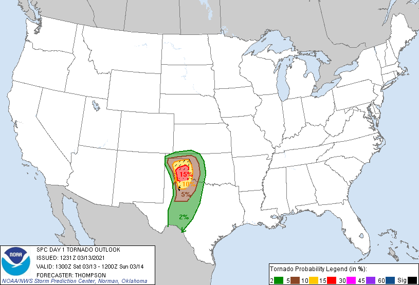
Big Spring, TX...Plainview, TX...Altus, OK...Canyon, TX...Woodward, OK...
2 %
60,571
1,281,636
Lubbock, TX...Abilene, TX...Wichita Falls, TX...Midland, TX...Lawton, OK...
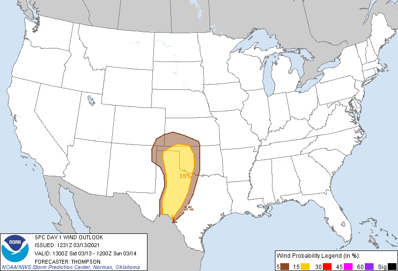
Probabilistic Damaging Wind Graphic
Probability of damaging thunderstorm winds or wind gusts of 50 knots or higher within 25 miles of a point. Hatched Area: 10% of greater probability of wind gusts 65 knots or greater within 25 miles of a point.
Day 1 Wind Risk
Area (sq. mi.)
Area Pop.
Some Larger Population Centers in Risk Area
15 %
92,580
1,479,852
Amarillo, TX...Abilene, TX...Wichita Falls, TX...Lawton, OK...San Angelo, TX...
5 %
65,318
2,097,435
Oklahoma City, OK...Lubbock, TX...Norman, OK...Midland, TX...Edmond, OK...
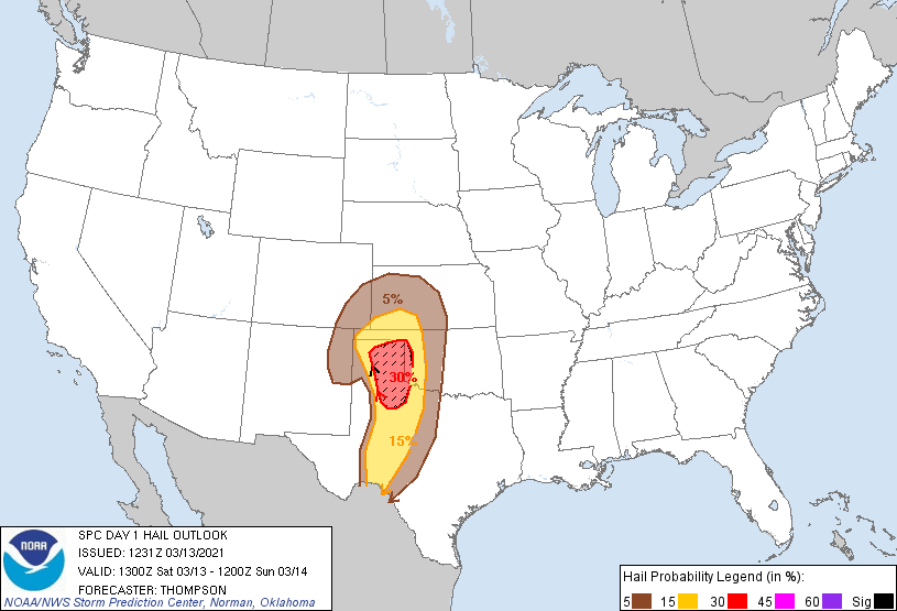
Probabilistic Large Hail Graphic
Probability of hail 1" or larger within 25 miles of a point. Hatched Area: 10% or greater probability of hail 2" or larger within 25 miles of a point.
Abilene, TX...San Angelo, TX...Dodge City, KS...Big Spring, TX...Plainview, TX...
5 %
97,722
1,588,124
Lubbock, TX...Wichita Falls, TX...Midland, TX...Lawton, OK...Enid, OK...
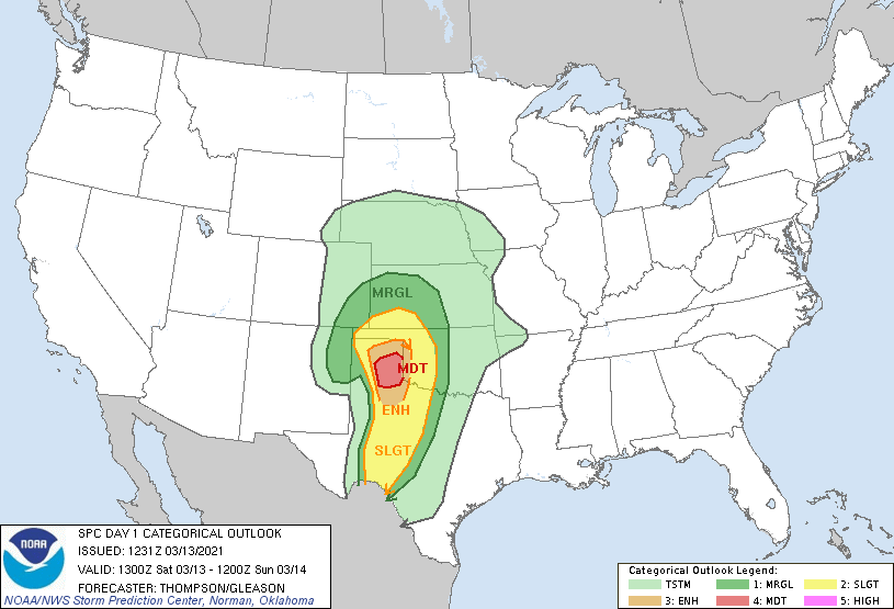
   SPC AC 131231

   Day 1 Convective Outlook
   NWS Storm Prediction Center Norman OK
   0631 AM CST Sat Mar 13 2021

   Valid 131300Z - 141200Z

   ...THERE IS A MODERATE RISK OF SEVERE THUNDERSTORMS THIS
   AFTERNOON/EVENING ACROSS THE EAST CENTRAL AND SOUTHEAST TX
   PANHANDLE...

   ...SUMMARY...
   Scattered to numerous severe storms are expected later today into
   early tonight from west Texas into western Oklahoma and southwestern
   Kansas.  The most significant severe weather threat, including
   strong tornadoes and very large hail, is expected this
   afternoon/evening across the east central and southeast Texas
   Panhandle.

   ...Southern High Plains through early tonight...
   A deep closed low over AZ will progress eastward to the southern
   High Plains by the end of the period.  In association with an
   embedded jet streak rotating northeastward around the eastern
   periphery of the low, a surface cyclone will develop
   north-northeastward from the TX Panhandle this afternoon to
   southwestern KS tonight.  The cyclogenesis will draw the surface
   warm sector northward across western OK and the TX Panhandle today
   to the east of a developing dryline, which will focus severe storm
   development this afternoon/evening.

   Some elevated convection is expected this morning from northeast NM
   northeastward into southwest KS, within the exit region of the
   mid-upper jet.  Midlevel lapse rates/buoyancy will be sufficient for
   isolated large hail with this convection.  Farther southeast and
   following a lull in the overnight convection, the warm sector will
   spread northward today, beneath midlevel lapse rates greater than 8
   C/km.  Moderate buoyancy (MLCAPE of 1500-2000 J/kg) is expected
   south of the warm front and east of the dryline this afternoon, with
   only weak convective inhibition along the dryline.  Initial storm
   development is expected early-mid afternoon along the dryline in the
   vicinity of I-27 in TX Panhandle/South Plains.  These initial storms
   will move off the dryline and maintain more discrete character as
   they encounter a moist, destabilizing warm sector with strong
   vertical shear.  Given boundary-layer dewpoints in the low 60s,
   afternoon temperatures of 65-70 F, effective bulk shear near 70 kt,
   and effective SRH in excess of 250 m2/s2, there will be a few hour
   window for a couple of supercells to produce long-track, strong
   tornadoes and very large hail across the east central/southeast TX
   Panhandle.

   West of the initial supercells, squall line development is expected
   by evening as a Pacific cold front overtakes the dryline and the
   stronger height falls/ascent overspread the TX Panhandle and west
   central TX.  Embedded supercell structures within the line will be
   capable of producing all hazards, though the overall severe threat
   will weaken with eastward extent during the early overnight hours,
   as a result of diminishing buoyancy.

   ..Thompson/Gleason.. 03/13/2021

   CLICK TO GET WUUS01 PTSDY1 PRODUCT

   NOTE: THE NEXT DAY 1 OUTLOOK IS SCHEDULED BY 1630Z