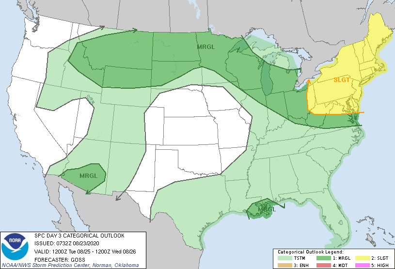
   SPC AC 230732

   Day 3 Convective Outlook
   NWS Storm Prediction Center Norman OK
   0232 AM CDT Sun Aug 23 2020

   Valid 251200Z - 261200Z

   ...THERE IS A SLIGHT RISK OF SEVERE THUNDERSTORMS ACROSS THE
   NORTHEAST...

   ...SUMMARY...
   The greatest risk for severe storms Tuesday will likely reside over
   the Northeast.  More isolated risk will extend from the northern
   Intermountain region to the Upper Great Lakes, and also across
   Arizona.  Risk for a brief/weak tornado or two may also develop as
   Laura approaches southeastern Louisiana.

   ...The Northeast...
   A strong cold front is forecast to shift across the U.S./Canada
   border and into New England early in the period, and then will
   advance quickly toward the coast, while sagging more slowly
   southward across the central Appalachians/Mid Atlantic region.
   Questions exist across New England, with respect to just how much
   destabilization will be able to occur ahead of the fast-moving
   boundary.  Still, with very strong flow aloft promoting rapid storm
   motions, risk for damaging winds will exist with any sustained
   convection.  If more destabilization than currently expected occurs
   ahead of the front -- particularly if frontal progression is slower
   in future model runs -- greater severe-weather probability would be
   likely across this area.

   Farther south, greater destabilization is expected ahead of the
   sagging front, but flow aloft will progressively weaken with
   southward extent.  Still, ample CAPE/shear combination is expected
   southward across the central Appalachians and into the Mid-Atlantic
   region to support risk for damaging winds and hail with stronger
   storms/storm clusters through afternoon and evening.

   ...Upper Great Lakes/Midwest region...
   Storms may be ongoing at the start of the period across portions of
   the Wisconsin/lower Michigan vicinity, with very limited/lingering
   severe potential possible with one or two of the stronger convective
   clusters.

   Meanwhile, with daytime heating supporting some destabilization
   along the trailing portion of the cold front crossing the Northeast,
   a few afternoon storms may redevelop near the boundary.  Given the
   anticyclonic belt of fast flow overhead, a stronger storm or two --
   capable of producing locally gusty/damaging winds or marginal hail
   -- will be possible.

   After dark, additional isolated/mainly elevated storms may evolve as
   a southwesterly low-level jet supports warm-advection-induced ascent
   into the upper Mississippi Valley/Upper Great Lakes region
   overnight.

   ...Northern Intermountain region into the northern Plains...
   Multiple, pronounced cyclonic mid-level disturbances are forecast to
   move in an easterly anticyclonic arc across the northern
   Intermountain region and northern Plains, embedded within a belt of
   fast flow around the northern periphery of the upper ridge.

   Heating/weak destabilization over the northern Intermountain region
   should promote isolated storm initiation over the higher terrain.
   Given fast mid-level flow promoting quickly moving storms, and some
   evaporative enhancement to downdrafts, locally gusty/damaging winds
   will be possible.

   Farther east into the northern Plains, a dry/capped boundary layer
   should act to temper convective development though the afternoon,
   with only isolated storm development expected at best.  Still, with
   fast flow aloft supporting potential for updraft organization,
   gusty/damaging winds would be possible with any storm which becomes
   sustained.

   Overnight, development of the southwesterly low-level jet may foster
   an increase in convection coverage, though storms would be primarily
   elevated above the capping layer.  Still, with some risk for hail
   and possibly gusty winds, this region will be included in a broad
   MRGL risk area across the northern Intermountain region across the
   northern Plains.

   ...Arizona...
   NAM forecasts suggest that small mid-level cyclonic disturbances
   will move southwestward across Arizona Tuesday and Tuesday night,
   within a weak belt of enhanced northeasterly mid-level flow.

   With modest destabilization forecast to occur through the afternoon,
   storms should develop over higher terrain/the Mogollon Rim, and then
   shift southeastward into the lower deserts.  With a very deep mixed
   layer promoting evaporative downdraft acceleration, risk for
   damaging winds appears sufficient to warrant MRGL/5% risk inclusion
   at this time.

   ...Central Gulf Coast region...
   Based on the current track forecasts from the National Hurricane
   Center, Laura is forecast to be moving northwestward across the
   eastern and central Gulf of Mexico Tuesday, reaching the
   north-central Gulf south of southeastern Louisiana by Wednesday
   morning.  Presuming this track proves accurate, a gradual increase
   in the low-level flow field would be expected with time.  While the
   breadth of convection surrounding the center of Laura remains
   uncertain, cells within outer banding, spreading onshore overnight,
   could pose low-end risk for brief tornadoes.

   ..Goss.. 08/23/2020

   CLICK TO GET WUUS03 PTSDY3 PRODUCT

   NOTE: THE NEXT DAY 3 OUTLOOK IS SCHEDULED BY 0730Z