New York, NY...Philadelphia, PA...Baltimore, MD...Washington, DC...Virginia Beach, VA...
MARGINAL
473,681
59,549,021
Memphis, TN...Charlotte, NC...Boston, MA...Oklahoma City, OK...Nashville, TN...
Probabilistic Tornado Graphic
Probability of a tornado within 25 miles of a point. Hatched Area: 10% or greater probability of EF2 - EF5 tornadoes within 25 miles of a point.
Day 2 Tornado Risk
Area (sq. mi.)
Area Pop.
Some Larger Population Centers in Risk Area
5 %
37,687
5,282,738
Virginia Beach, VA...Raleigh, NC...Norfolk, VA...Chesapeake, VA...Richmond, VA...
2 %
176,385
59,766,963
New York, NY...Philadelphia, PA...Baltimore, MD...Washington, DC...Tulsa, OK...
Probabilistic Damaging Wind Graphic
Probability of damaging thunderstorm winds or wind gusts of 50 knots or higher within 25 miles of a point. Hatched Area: 10% of greater probability of wind gusts 65 knots or greater within 25 miles of a point.
Day 2 Wind Risk
Area (sq. mi.)
Area Pop.
Some Larger Population Centers in Risk Area
15 %
137,180
39,343,481
New York, NY...Philadelphia, PA...Baltimore, MD...Washington, DC...Virginia Beach, VA...
5 %
473,662
59,548,786
Memphis, TN...Charlotte, NC...Boston, MA...Oklahoma City, OK...Nashville, TN...
Probabilistic Large Hail Graphic
Probability of hail 1" or larger within 25 miles of a point. Hatched Area: 10% or greater probability of hail 2" or larger within 25 miles of a point.
Memphis, TN...Oklahoma City, OK...Wichita, KS...Little Rock, AR...Amarillo, TX...
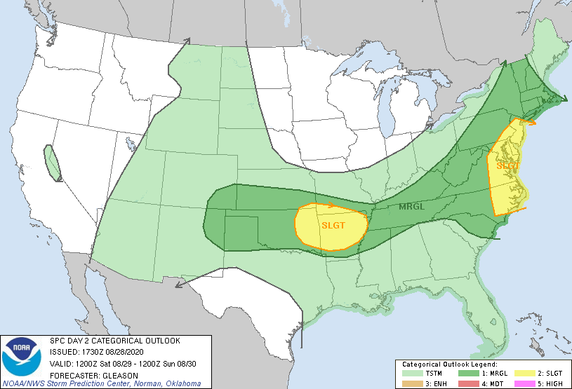
   SPC AC 281730

   Day 2 Convective Outlook
   NWS Storm Prediction Center Norman OK
   1230 PM CDT Fri Aug 28 2020

   Valid 291200Z - 301200Z

   ...THERE IS A SLIGHT RISK OF SEVERE THUNDERSTORMS ACROSS PARTS OF
   EASTERN NC INTO THE MID-ATLANTIC...AND EASTERN OK INTO AR...

   ...SUMMARY...
   Severe storms may occur from parts of eastern Oklahoma into Arkansas
   Saturday afternoon and evening with damaging winds and large hail
   the main threats. A risk for a few strong to severe storms may also
   exist from portions of the Carolinas into the Mid-Atlantic and New
   England during the day with damaging winds and perhaps a couple of
   tornadoes possible.

   ...Carolinas into the Mid-Atlantic and New England...
   The mid-level perturbation associated with the remnants of Laura
   will move quickly eastward from the central Appalachians across VA
   and the Carolinas Saturday morning and early afternoon. A
   large-scale upper trough initially over Ontario and the Great Lakes
   is also forecast to move eastward across the Northeast and
   Mid-Atlantic through the period. Widespread cloudiness and
   precipitation will likely be ongoing at the start of the period
   Saturday morning across the southern/central Appalachians in
   association with the remnants of Laura. As this precipitation shield
   shifts eastward across NC and the Mid-Atlantic through the day, it
   should hinder diurnal destabilization. Poor mid-level lapse rates
   will also tend to limit instability, with MLCAPE generally in the
   500-1000 J/kg range.

   Even so, there still appears to be some potential for isolated
   strong to severe storm development by early Saturday afternoon,
   mainly across eastern portions of NC into the Mid-Atlantic where
   mid-level southwesterly flow will be modestly enhanced. Damaging
   winds should be the main threat with small clusters/bows moving
   eastward, but a couple tornadoes may also occur as southwesterly
   low-level winds of 30-40 kt should encourage some updraft rotation.
   Farther north across NY and New England, isolated strong to severe
   storms could develop along/ahead of a surface cold front through the
   day, with strong to locally damaging winds and marginally severe
   hail possible. Deep-layer shear should be fairly strong across this
   area (30-40 kt), but modest instability suggests that a Marginal
   Risk is sufficient for now.

   ...Southern/Central Plains into Arkansas...
   Convection may be ongoing Saturday morning across parts of
   western/central KS generally to the north of a cold front. Current
   expectations are for a remnant MCV and associated mid-level
   vorticity maximum to move eastward across KS through the day, and to
   the north of a weak surface low near the Red River. A very moist
   low-level airmass, characterized by low to mid 70s surface
   dewpoints, will likely be in place ahead of the MCV and to the
   north/east of the surface low. Strong diurnal heating of this moist
   airmass is likely, and with modestly steepened mid-level lapse rates
   also present, peak afternoon MLCAPE should reach 2500-3500+ J/kg.
   Around 25-35 kt of mid-level westerly flow should support modest
   storm organization, with initially discrete convection across
   eastern OK likely to congeal and form into a bowing line segment
   across AR. Isolated large hail will be possible with the initial
   storms, before transitioning to more of a severe/damaging wind
   threat Saturday evening across AR and vicinity.

   Farther west, more isolated strong to severe storms may form
   Saturday afternoon across the higher terrain of the southern/central
   High Plains in a low-level, post-frontal upslope flow regime.
   Although instability will probably remain rather limited, modest
   enhancement to the westerly mid-level flow may support storm
   organization. Isolated instances of large hail and severe wind gusts
   appear possible as storms move eastward through Saturday evening.
   The Marginal Risk has been expanded southward into more of the
   southern High Plains to account for the possibility of one or more
   loosely organized clusters moving across this region.

   ..Gleason.. 08/28/2020

   CLICK TO GET WUUS02 PTSDY2 PRODUCT

   NOTE: THE NEXT DAY 2 OUTLOOK IS SCHEDULED BY 0600Z