Probability of a tornado within 25 miles of a point. Hatched Area: 10% or greater probability of EF2 - EF5 tornadoes within 25 miles of a point.
Day 2 Tornado Risk
Area (sq. mi.)
Area Pop.
Some Larger Population Centers in Risk Area
2 %
73,771
8,573,201
Dallas, TX...Fort Worth, TX...Oklahoma City, OK...Tulsa, OK...Arlington, TX...
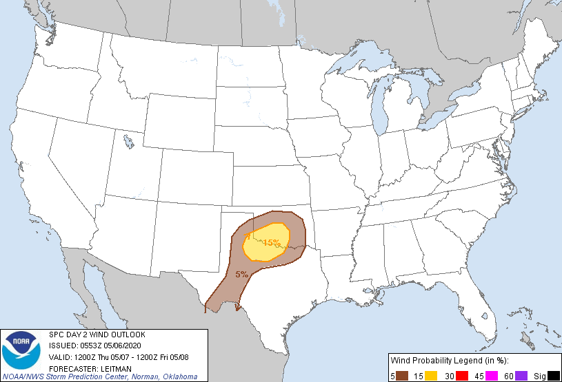
Probabilistic Damaging Wind Graphic
Probability of damaging thunderstorm winds or wind gusts of 50 knots or higher within 25 miles of a point. Hatched Area: 10% of greater probability of wind gusts 65 knots or greater within 25 miles of a point.
Day 2 Wind Risk
Area (sq. mi.)
Area Pop.
Some Larger Population Centers in Risk Area
15 %
35,801
1,883,760
Oklahoma City, OK...Norman, OK...Wichita Falls, TX...Lawton, OK...Edmond, OK...
   SPC AC 060553

   Day 2 Convective Outlook
   NWS Storm Prediction Center Norman OK
   1253 AM CDT Wed May 06 2020

   Valid 071200Z - 081200Z

   ...THERE IS A SLIGHT RISK OF SEVERE THUNDERSTORMS ACROSS PORTIONS OF
   WESTERN NORTH TX INTO SOUTHWEST AND CENTRAL OK...

   ...SUMMARY...
   Isolated severe thunderstorms capable of large hail and locally
   damaging wind gusts are possible across parts of western north Texas
   into southwest and central Oklahoma on Thursday.

   ...OK/TX Vicinity...

   A compact and intense upper shortwave trough over the northern
   Rockies Thursday morning will dive south/southeast across the
   central/southern Plains and merge with the larger-scale upper trough
   over the eastern U.S. by Friday morning in the vicinity of the
   mid-MS Valley. In response, a lee low is forecast to develop near
   the TX Panhandle, with a dryline extending southward from the low
   across west TX. Mid 50s to low 60s F surface dewpoints will spread
   northward on increasing low-level southerly flow ahead of the
   dryline and as far north as southern/central OK.

   Boundary-layer moisture is not expected to be high-quality or very
   deep, given the airmass will still be modifying from an earlier cold
   frontal passage. Nevertheless, very steep midlevel lapse rates atop
   a weak EML will be present, and increasing moisture combined with
   strong forcing should be adequate for thunderstorm development in a
   moderately unstable airmass. Vertical wind profiles suggest
   high-based supercells will develop near the triple point from the
   eastern TX Panhandle into western OK during the late afternoon/early
   evening. Lapse rates greater than 8 C/km, and long hodographs above
   backed 0-3 km flow, should support large hail, some of which could
   be larger than 2 inches in diameter. As such, a SIG hail area has
   been added. Strong heating will result in a fairly deeply mixed
   boundary layer with inverted-v sub-cloud thermodynamic profiles.
   This will foster strong downburst winds in addition to the
   severe-hail threat. Given the modest boundary layer moisture and
   well-mixed boundary layer, the tornado threat appears very low.

   Further south, strong heating across far west TX will result in a
   sharp dryline with modest low level confluence along the boundary.
   Various guidance, including CAMs, develop at least a couple of
   storms along the dryline during the late afternoon/evening. This
   threat appears more isolated/conditional compared to further north
   near the surface low, but if storms do develop, large hail and
   strong gusts will be possible.

   During the overnight hours, a cold front will dive southward into
   the southern Plains. Additional storms may develop ahead of the
   boundary, or ongoing storms could grow upscale into one or more
   small line segments as storm track south/southeast into north TX.
   Hail and strong gusts may continue into the nighttime hours with
   this activity.

   ..Leitman.. 05/06/2020

   CLICK TO GET WUUS02 PTSDY2 PRODUCT

   NOTE: THE NEXT DAY 2 OUTLOOK IS SCHEDULED BY 1730Z