Fort Wayne, IN...Grand Rapids, MI...Des Moines, IA...Lansing, MI...Peoria, IL...
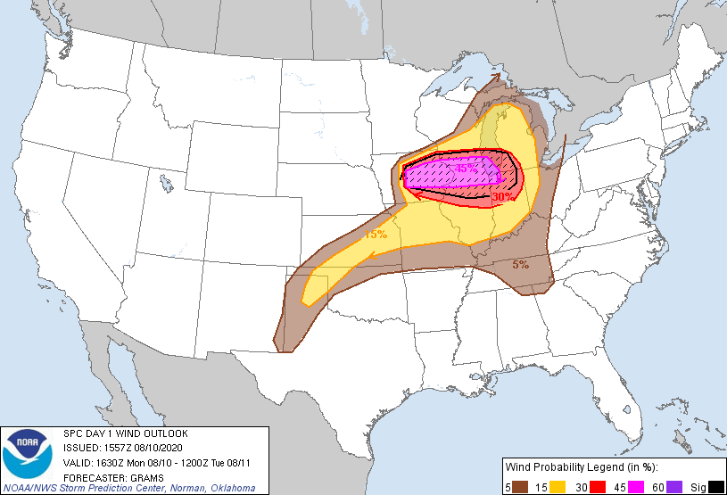
Probabilistic Damaging Wind Graphic
Probability of damaging thunderstorm winds or wind gusts of 50 knots or higher within 25 miles of a point. Hatched Area: 10% of greater probability of wind gusts 65 knots or greater within 25 miles of a point.
Probability of hail 1" or larger within 25 miles of a point. Hatched Area: 10% or greater probability of hail 2" or larger within 25 miles of a point.
Day 1 Hail Risk
Area (sq. mi.)
Area Pop.
Some Larger Population Centers in Risk Area
15 %
24,732
2,302,376
Madison, WI...Green Bay, WI...Appleton, WI...Waterloo, IA...Oshkosh, WI...
5 %
298,074
29,278,440
Chicago, IL...Milwaukee, WI...Kansas City, MO...Wichita, KS...St. Louis, MO...
SPC AC 101557
Day 1 Convective Outlook
NWS Storm Prediction Center Norman OK
1057 AM CDT Mon Aug 10 2020
Valid 101630Z - 111200Z
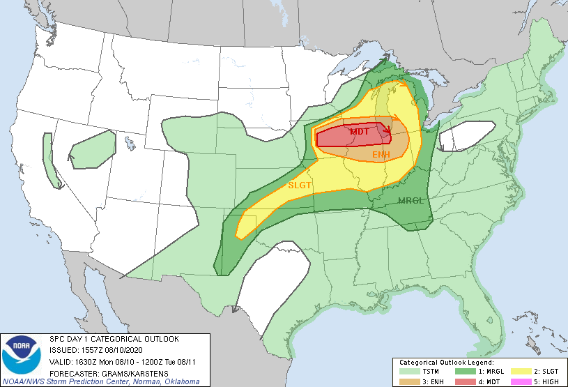
...THERE IS A MODERATE RISK OF SEVERE THUNDERSTORMS CENTRAL AND
EASTERN IOWA...NORTHERN ILLINOIS...FAR SOUTHERN WISCONSIN...AND FAR
NORTHWEST INDIANA...
...SUMMARY...
A derecho producing widespread damaging winds, some of which should
be intense, is expected to persist and expand east from Iowa into
parts of the Midwest through this evening.
...IA to the Midwest...
A pair of impulses embedded within a shortwave trough over the Upper
Midwest will rapidly progress east. A 50+ kt jetlet should persist
from eastern SD into southern WI through early evening. An intense
MCS with a well-developed rear-inflow jet is ongoing to the south of
the mid-level jet across central IA. Very steep mid-level lapse
rates around 9 C/km per 12Z OAX and DVN soundings along with robust
boundary-layer heating ahead of it should support maintenance of
this MCS this afternoon. On the fringe of the stronger mid-level
westerlies, a pronounced bow should sweep eastward across eastern IA
and the northern IA vicinity. The MCS should enlarge as well as
convection develops northeast along a surface front into southern
WI. For more in-depth discussion of the short-term severe threat,
please see MCD 1450.
Given large buoyancy and steep low to mid-level lapse rates within
the gradient of moderate to strong mid-level westerlies, potential
will exist for a derecho with intense severe gusts and widespread
wind damage across parts of central to eastern IA into northern IL
and far southern WI.
The MCS will likely persist east into Lower MI and IN while
developing southwestward into a high MLCAPE environment to the
southwest in central and southern IL. While deep-layer shear will
drop off with southern extent and steeper lapse rates with eastern
extent, a severe risk mainly in the form of damaging winds will
probably continue on a more scattered basis this evening in the
Midwest before eventual decay tonight.
...MO to the TX Panhandle..
Pockets of strong surface heating will result in a plume of large
buoyancy ahead of a southward-moving cold front. Scattered late
afternoon and evening multicell thunderstorms are expected to
develop, with the strongest cells primarily capable of severe wind
gusts.
..Grams/Karstens.. 08/10/2020
CLICK TO GET WUUS01 PTSDY1 PRODUCT
NOTE: THE NEXT DAY 1 OUTLOOK IS SCHEDULED BY 2000Z