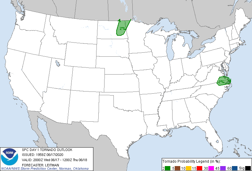
Virginia Beach, VA...Norfolk, VA...Chesapeake, VA...Lubbock, TX...Newport News, VA...
Probabilistic Tornado Graphic
Probability of a tornado within 25 miles of a point. Hatched Area: 10% or greater probability of EF2 - EF5 tornadoes within 25 miles of a point.
Day 1 Tornado Risk
Area (sq. mi.)
Area Pop.
Some Larger Population Centers in Risk Area
2 %
28,885
2,311,585
Virginia Beach, VA...Norfolk, VA...Chesapeake, VA...Newport News, VA...Hampton, VA...
Probabilistic Damaging Wind Graphic
Probability of damaging thunderstorm winds or wind gusts of 50 knots or higher within 25 miles of a point. Hatched Area: 10% of greater probability of wind gusts 65 knots or greater within 25 miles of a point.
North Platte, NE...Watertown, SD...Mitchell, SD...Fergus Falls, MN...Bemidji, MN...
   SPC AC 171959

   Day 1 Convective Outlook
   NWS Storm Prediction Center Norman OK
   0259 PM CDT Wed Jun 17 2020

   Valid 172000Z - 181200Z

   ...THERE IS A SLIGHT RISK OF SEVERE THUNDERSTORMS ACROSS PORTIONS OF
   THE NORTHERN AND CENTRAL PLAINS...

   ...SUMMARY...
   Scattered severe thunderstorms are possible across parts of
   western/northern Nebraska and central/eastern Dakotas into
   northwestern Minnesota, through this evening. A couple of strong
   storms may also impact parts of northeastern North Carolina into
   southeastern Virginia as well as the southern High Plains.

   ...20z Update...

   The previous outlook philosophy remains on track, though the Slight
   risk has been expanded south/southwestward a bit across a portions
   of western/central NE. Visible satellite imagery shows more
   widespread CU development is occurring to the south of elevated
   storms over northeast ND, southward into parts of central SD and NE.
   Moderate destabilization has occurred as temperatures have warmed
   into the low to mid 90s F with dewpoints generally in the low 60s F.
   While effective shear will remain strongest further north, effective
   shear near 30-35 kt into parts of central/western NE should be
   adequate for organized updrafts. This environment is overall similar
   to points northward across SD and latest HRRR trends show potential
   for at least a few hours of potential cellular convection is
   possible, posing a threat for hail and damaging gusts. As such, the
   Slight risk has been expanded across these parts of NE.

   Elsewhere, the outlook remains unchanged. Widely scattered
   thunderstorms are expected to develop along a dryline across western
   TX later this afternoon/evening. Shear will remain very weak across
   the region. Although strong instability and very steep midlevel
   lapse rates are present, the main threat with these storms should be
   gusty downburst winds. A stronger storm could produce hail, though
   this is not expected to be widespread and generally intense updrafts
   should be short-lived, limiting any hail that does occur to
   sub-severe levels.

   ..Leitman.. 06/17/2020

   .PREV DISCUSSION... /ISSUED 1141 AM CDT Wed Jun 17 2020/

   ...Northern Plains...
   The persistent upper trough centered over the northern/central
   Rockies will shift only slowly eastward today, with moderately
   strong southwesterly mid/high-level winds extending eastward atop a
   slow-eastward-moving front across the Dakotas/western Nebraska.
   Southerly low-level winds to the east of the front will result in a
   slow moistening of the boundary layer, with dewpoints likely
   climbing into the mid 60s F. This will support upwards of 2000-3000
   J/kg MLCAPE from north-central Nebraska into east-central South
   Dakota and eastern North Dakota by peak heating.

   The exact timing of deep convective initiation is still a bit
   uncertain, but at least widely scattered thunderstorms should
   develop/quickly intensify by around 23-00z in vicinity of the front.
   Steep mid-level lapse rates and aforementioned buoyancy in the
   presence of 30-40 kt of effective shear will support both supercells
   and well-organized multicells capable of large hail as well as
   strong wind gusts.

   ...Northeast North Carolina/southeast Virginia...
   Bands of isolated thunderstorms are expected across the region in
   association with a narrow warm sector on the eastern periphery of
   the nearly vertically stacked low. While mid-level lapse rates will
   remain weak, adequate heating/destabilization and moderately strong
   wind profiles, particularly near the warm front, may support a few
   organized storms, possibly with weak supercell characteristics.
   Localized wind damage and/or a brief tornado could occur. Reference
   Mesoscale Discussion 924 for additional short-term details.

   ...West Texas/Far eastern New Mexico...
   In the wake of early day mid-level convection, a hot/well-mixed
   modestly moist boundary will develop near/east of the dryline this
   afternoon. Isolated to widely scattered high-based thunderstorms
   should develop by around peak heating. Some of the stronger storms
   could produce severe-caliber wind gusts through the late
   afternoon/early evening hours.

   CLICK TO GET WUUS01 PTSDY1 PRODUCT

   NOTE: THE NEXT DAY 1 OUTLOOK IS SCHEDULED BY 0100Z