Atlanta, GA...Columbus, GA...Sandy Springs, GA...Macon, GA...Fargo, ND...
Probabilistic Tornado Graphic
Probability of a tornado within 25 miles of a point. Hatched Area: 10% or greater probability of EF2 - EF5 tornadoes within 25 miles of a point.
Day 1 Tornado Risk
Area (sq. mi.)
Area Pop.
Some Larger Population Centers in Risk Area
2 %
15,479
178,965
Grand Forks, ND...Grafton, ND...
Probabilistic Damaging Wind Graphic
Probability of damaging thunderstorm winds or wind gusts of 50 knots or higher within 25 miles of a point. Hatched Area: 10% of greater probability of wind gusts 65 knots or greater within 25 miles of a point.
Day 1 Wind Risk
Area (sq. mi.)
Area Pop.
Some Larger Population Centers in Risk Area
5 %
55,650
7,636,655
Atlanta, GA...Columbus, GA...Sandy Springs, GA...Macon, GA...Fargo, ND...
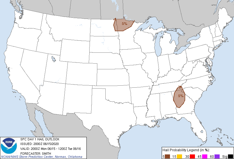
Probabilistic Large Hail Graphic
Probability of hail 1" or larger within 25 miles of a point. Hatched Area: 10% or greater probability of hail 2" or larger within 25 miles of a point.
Day 1 Hail Risk
Area (sq. mi.)
Area Pop.
Some Larger Population Centers in Risk Area
5 %
55,633
7,604,041
Atlanta, GA...Columbus, GA...Sandy Springs, GA...Macon, GA...Fargo, ND...
   SPC AC 152000

   Day 1 Convective Outlook
   NWS Storm Prediction Center Norman OK
   0300 PM CDT Mon Jun 15 2020

   Valid 152000Z - 161200Z

   ...THERE IS A MARGINAL RISK OF SEVERE THUNDERSTORMS ACROSS EASTERN
   NORTH DAKOTA/NORTHERN MINNESOTA AND PARTS OF THE SOUTHERN
   APPALACHIANS/GEORGIA...

   ...SUMMARY...
   Isolated severe thunderstorms are possible across parts of far
   eastern North Dakota and northern Minnesota late this afternoon and
   evening.  A couple of strong storms posing a risk for hail and gusty
   winds are also possible across the southern Appalachians and
   northern/central Georgia this afternoon.

   ...Discussion...
   No appreciable change was made to the previous convective outlook.

   ..Smith.. 06/15/2020

   .PREV DISCUSSION... /ISSUED 1131 AM CDT Mon Jun 15 2020/

   ...Far eastern North Dakota and northern Minnesota...
   The southward extent and related likelihood/coverage of deep
   convection later today remains a bit uncertain, with somewhat higher
   probabilities for thunderstorms and a related severe risk in closer
   proximity to the international border across far eastern North
   Dakota and far northern Minnesota. Modest mid-level height
   rises/warming will tend to occur today in the wake of a mid-level
   impulse/MCV, which has influenced lingering showers/cloud cover
   through late morning.

   As clouds clear, moderate destabilization is anticipated within a
   relatively narrow warm sector characterized by low/mid 60s F surface
   dewpoints and 2000-3000 J/kg MLCAPE. Where storms do form, upwards
   of 40 kt effective shear could support a few supercells capable of
   large hail, and potentially a non-zero tornado risk. Pending the
   extent of storm coverage, a small cluster of storms could ultimately
   develop and move across and/or move into the Lake of the Woods
   vicinity and far north-central Minnesota this evening, before
   tending to diminish in intensity by the late afternoon/early
   overnight hours.

   ...Southern Appalachians/Georgia...
   A vort max on the western periphery of a southern
   Appalachians-centered upper low will continue to spread
   south-southeastward over  the region today. While the boundary layer
   is not overly moist and drying/mixing will tend to occur,
   thunderstorms are expected to increase in coverage and intensity
   across the region this afternoon. Aided by relatively cool mid-level
   temperatures, some hail may occur, while locally damaging winds are
   a possibility as well given a well-mixed boundary layer.

   CLICK TO GET WUUS01 PTSDY1 PRODUCT

   NOTE: THE NEXT DAY 1 OUTLOOK IS SCHEDULED BY 0100Z