Probability of damaging thunderstorm winds or wind gusts of 50 knots or higher within 25 miles of a point. Hatched Area: 10% of greater probability of wind gusts 65 knots or greater within 25 miles of a point.
Fort Worth, TX...Arlington, TX...Little Rock, AR...Denton, TX...Sandy Springs, GA...
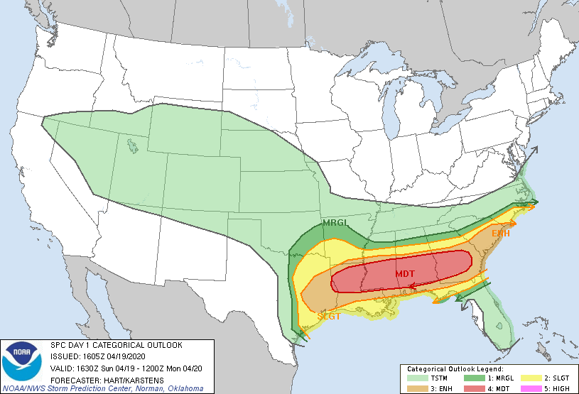
   SPC AC 191605

   Day 1 Convective Outlook
   NWS Storm Prediction Center Norman OK
   1105 AM CDT Sun Apr 19 2020

   Valid 191630Z - 201200Z

   ...THERE IS A MODERATE RISK OF SEVERE THUNDERSTORMS EXTENDING FROM
   PARTS OF LOUISIANA INTO MISSISSIPPI...ALABAMA...AND GEORGIA...

   ...SUMMARY...
   A severe-weather outbreak is expected across much of the Deep South
   through tonight, with the greatest threat from east Texas and the
   Delta region eastward across parts of Alabama and Georgia.  Multiple
   episodes of thunderstorms will result in tornadoes (some strong),
   damaging wind and large hail.

   ...TX/LA/MS/AL...
   Several large clusters of intense thunderstorms have developed this
   morning over east TX and western LA.  These storms are in a region
   of increasing large-scale lift ahead of the an approaching shortwave
   trough.  Very steep midlevel lapse rates and ample CAPE, along with
   deep-layer shear sufficient for rotating storms, will promote the
   potential for large hail and damaging winds in the stronger cells.
   Local VAD profiles also show sufficient low-level shear for a risk
   of a few tornades - especially this afternoon as low-level jet
   strengthens.

   A well-defined warm front extends from central LA eastward into
   MS/AL.  Clusters of storms will track along and south of the warm
   front this afternoon and evening.  Forecast soundings show
   parameters favorable for all modes of severe.  Hodographs will
   become quite large through the day, supportive of strong tornadoes
   in the more discrete supercells that may form.  A few of the
   clusters may also develop into fast-moving bowing structures capable
   of locally damaging wind gusts.  It appears likely that the corridor
   along and south of the warm front (within the MDT risk) may see
   several rounds of strong/severe convection this afternoon into
   tonight.

   ...AL/GA/SC...
   A large shield of ongoing showers and thunderstorms is affecting
   parts AL/GA/SC today.  The aforementioned warm front is building
   northward, and is nearing the southern fringes of the convection.
   Once that occurs, surface-based parcels will be realized by the
   storms and the risk of severe weather should increase.  Damaging
   winds and hail will be possible, but the proximity of the warm front
   and strengthening low-level shear/helicity this afternoon will also
   support a risk of tornadoes.

   Later tonight, storms over MS/AL will track eastward and also affect
   this region.  Parameters will remain quite strong through the
   overnight period, with a considerable risk of bowing structures
   capable of damaging winds, and the threat of supercell storms
   producing tornadoes (some strong).

   ..Hart/Karstens.. 04/19/2020

   CLICK TO GET WUUS01 PTSDY1 PRODUCT

   NOTE: THE NEXT DAY 1 OUTLOOK IS SCHEDULED BY 2000Z