Fort Worth, TX...Abilene, TX...Wichita Falls, TX...Denton, TX...Lewisville, TX...
SLIGHT
130,393
9,027,636
Dallas, TX...Oklahoma City, OK...Tulsa, OK...Arlington, TX...Plano, TX...
MARGINAL
150,102
10,713,540
San Antonio, TX...Austin, TX...Kansas City, MO...Wichita, KS...Amarillo, TX...
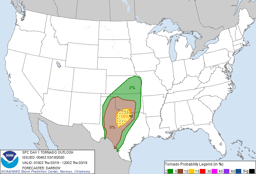
Probabilistic Tornado Graphic
Probability of a tornado within 25 miles of a point. Hatched Area: 10% or greater probability of EF2 - EF5 tornadoes within 25 miles of a point.
Day 1 Tornado Risk
Area (sq. mi.)
Area Pop.
Some Larger Population Centers in Risk Area
SIG SEVERE
25,546
2,200,613
Fort Worth, TX...Abilene, TX...Wichita Falls, TX...Denton, TX...Lewisville, TX...
10 %
25,985
2,383,562
Fort Worth, TX...Abilene, TX...Wichita Falls, TX...Denton, TX...Lewisville, TX...
5 %
103,619
7,426,663
Dallas, TX...Oklahoma City, OK...Arlington, TX...Plano, TX...Garland, TX...
2 %
111,190
8,474,777
San Antonio, TX...Kansas City, MO...Tulsa, OK...Wichita, KS...Amarillo, TX...
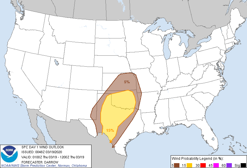
Probabilistic Damaging Wind Graphic
Probability of damaging thunderstorm winds or wind gusts of 50 knots or higher within 25 miles of a point. Hatched Area: 10% of greater probability of wind gusts 65 knots or greater within 25 miles of a point.
Day 1 Wind Risk
Area (sq. mi.)
Area Pop.
Some Larger Population Centers in Risk Area
15 %
154,160
11,504,358
Dallas, TX...Fort Worth, TX...Oklahoma City, OK...Tulsa, OK...Arlington, TX...
5 %
151,046
10,723,532
San Antonio, TX...Austin, TX...Kansas City, MO...Wichita, KS...Amarillo, TX...
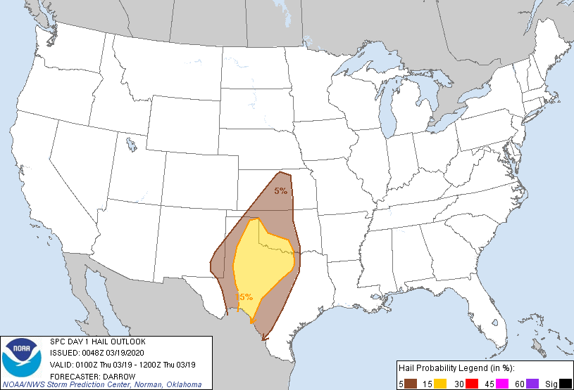
Probabilistic Large Hail Graphic
Probability of hail 1" or larger within 25 miles of a point. Hatched Area: 10% or greater probability of hail 2" or larger within 25 miles of a point.
Day 1 Hail Risk
Area (sq. mi.)
Area Pop.
Some Larger Population Centers in Risk Area
15 %
93,091
4,352,364
Fort Worth, TX...Arlington, TX...Lubbock, TX...Abilene, TX...Wichita Falls, TX...
5 %
131,936
11,413,712
San Antonio, TX...Dallas, TX...Austin, TX...Oklahoma City, OK...Wichita, KS...
SPC AC 190048
Day 1 Convective Outlook
NWS Storm Prediction Center Norman OK
0748 PM CDT Wed Mar 18 2020
Valid 190100Z - 191200Z
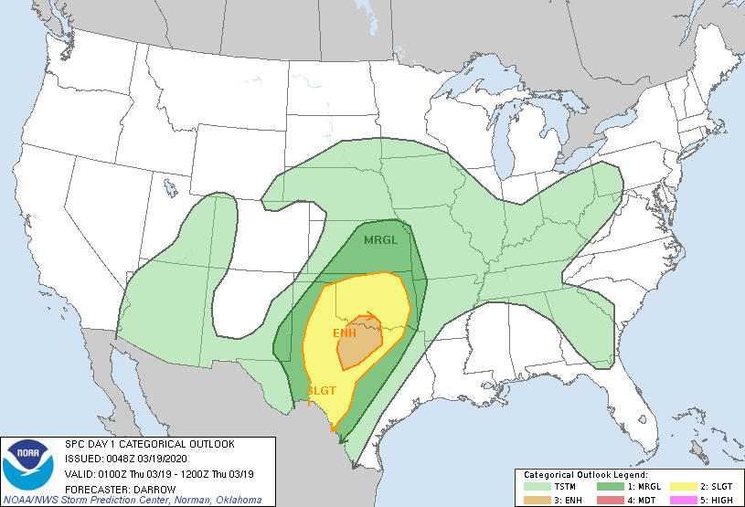
...THERE IS AN ENHANCED RISK OF SEVERE THUNDERSTORMS ACROSS PORTIONS
OF THE SOUTHERN PLAINS...
...SUMMARY...
Scattered severe thunderstorms will continue tonight across parts of
the southern and central Plains. Severe wind gusts, large hail, and
tornadoes are possible.
...Discussion...
Weak disturbance aloft appears partly responsible for initiating
convection across northwest TX well ahead of the primary upper
trough. While this activity was initially supercellular in nature,
storm maturation has resulted in several clusters, and short line
segments. 00z soundings from FWD and OUN exhibit substantial
buoyancy with deep-layer shear more than adequate for sustained
rotating updrafts. There is some concern that renewed thunderstorm
activity will be noted later this evening across west TX as the
influence of the approaching trough reaches the western plume of
higher boundary-layer moisture. While the strongest mid-level height
falls will spread into the central High Plains, thunderstorms should
increase once again then spread toward the I-35 corridor by sunrise
Thursday. Primary storm mode should be mixed with clusters, line
segments, and isolated supercells. For these reasons will maintain
probabilities for all severe hazards.
..Darrow.. 03/19/2020
CLICK TO GET WUUS01 PTSDY1 PRODUCT
NOTE: THE NEXT DAY 1 OUTLOOK IS SCHEDULED BY 0600Z