SPC AC 140952
Day 3 Convective Outlook CORR 1
NWS Storm Prediction Center Norman OK
0352 AM CST Sat Dec 14 2019
Valid 161200Z - 171200Z
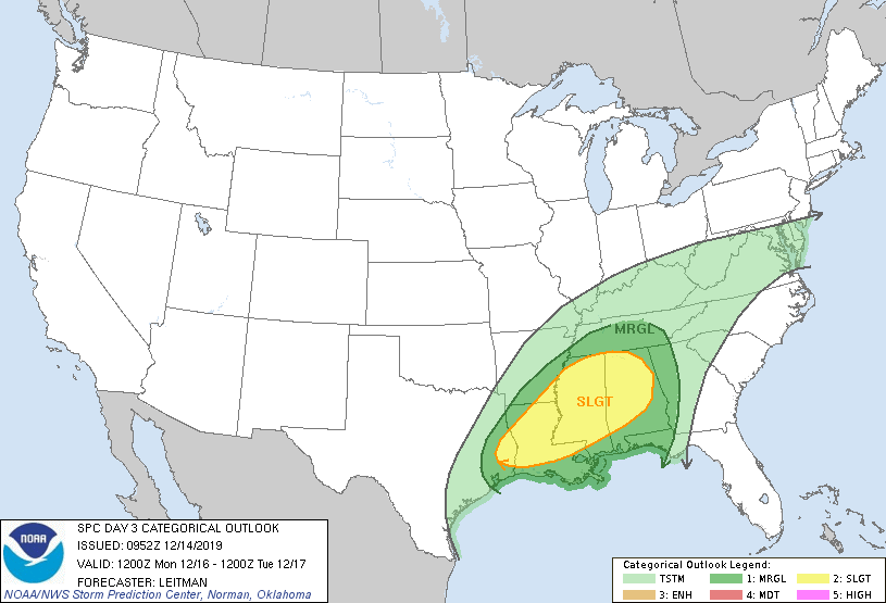
...THERE IS A SLIGHT RISK OF SEVERE THUNDERSTORMS ACROSS FAR
SOUTHEAST AR...EASTERN TX...MUCH OF LA...MS AND AL...
CORRECTED FOR STATE ID TYPO
...SUMMARY...
Isolated to scattered severe storms are expected Monday into Monday
night from far eastern Texas into the lower Mississippi Valley and
much of Mississippi and Alabama. Damaging wind gusts, a few
tornadoes and isolated hail are all possible.
...Lower MS Valley into the Deep South Vicinity...
Forecast guidance continues to trend deeper with the
eastward-ejecting mid/upper trough moving across the Plains to the
central U.S. on Monday. As a result, a weak surface low over AR
during the morning is forecast to track more east/northeast into
northern MS then into TN/KY. This will keep the warm sector confined
further south across the lower MS Valley vicinity into the Gulf
coast states. 60s F surface dewpoints will overspread much of the
Gulf coast states ahead of an eastward-advancing cold front.
Vertical shear continues to be impressive and supportive of
supercells. Furthermore, latest forecast soundings from various
guidance show some improvement in low level hodographs and
convergence ahead of the front. This could act to increase tornado
potential across parts of LA/MS/AL into the evening hours. However,
deep layer southwesterly flow will generally be parallel to the
surface front. As a result, a messy storm mode/evolution is expected
with a mix of line segments/clusters and perhaps a few semi-discrete
cells. MLCAPE will remain modest, around 500-750 J/kg, limited in
part by cloud cover/weaker insolation. However, some areas that
experience pockets of stronger heating could destabilize further.
Midlevel lapse rates will be moderate, around 6.5-7.0 C/km and could
result in some hail in more discrete modes. Otherwise, strong wind
gusts and a few tornadoes (either from semi-discrete cells or via
mesovortices in line segments) are expected.
South and east extent of the Slight risk area remains somewhat in
question given concerns over forcing, somewhat weaker shear and
storms developing/moving into the area after peak heating.
Therefore, expect some changes on the periphery of the Slight risk
area in coming outlooks as details hopefully become clearer.
..Leitman.. 12/14/2019
CLICK TO GET WUUS03 PTSDY3 PRODUCT
NOTE: THE NEXT DAY 3 OUTLOOK IS SCHEDULED BY 0830Z