SPC AC 150728
Day 3 Convective Outlook
NWS Storm Prediction Center Norman OK
0228 AM CDT Mon Apr 15 2019
Valid 171200Z - 181200Z
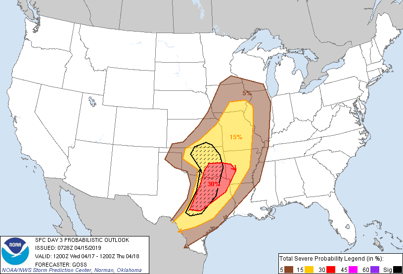
...THERE IS AN ENHANCED RISK OF SEVERE THUNDERSTORMS FROM PARTS OF
EASTERN OKLAHOMA AND WESTERN ARKANSAS SOUTHWEST ACROSS PARTS OF
CENTRAL AND EASTERN TEXAS...
...SUMMARY...
Strong/severe storms are forecast Wednesday afternoon and evening,
from the Iowa vicinity south-southwest into the southern Plains.
...Synopsis...
A gradually strengthening upper trough will move out of the Rockies
and into the Plains Wednesday, and will be the primary feature of
interest this period. Flanking the trough, ridging will encompass
the western and eastern portions of the country.
At the surface, a weak low initially over Kansas is forecast to
shift northeastward to Iowa by sunset, and then into the northern
Illinois/Wisconsin area overnight. Along a trailing cold front,
models forecast weak secondary/frontal low development over the
southwest Oklahoma vicinity during the afternoon -- likely near the
intersection of the front an a southward-extending dryline. This
cold front and dryline should focus late afternoon development of
strong/locally severe storms.
...Portions of the central and southern Plains east to the lower
Missouri/mid Mississippi Valleys...
As low-level moisture spreads gradually northward on southerly flow
ahead of the advancing storm system, steep lapse rates associated
with eastward advection of an elevated mixed layer will result in
development of a moderately unstable but capped warm sector.
Capping should hinder convective development -- particularly over
the southern Plains -- until late afternoon, but expect storms to
eventually develop along the cold front, and southward along an
eastward-mixing dryline as ascent increases in advance of the
strengthening upper system.
With flow aloft forecast to gradually strengthen as the trough
advances, shear sufficient for supercells will reside across much of
the area by afternoon. As such, developing storms will likely
become quickly severe given the degree of CAPE expected, with very
large hail likely to be the primary severe risk. Greatest risk for
the largest hail appears to exist across the southern Plains, near
the axis of steepest lapse rates associated with the elevated mixed
layer advecting northeastward from northern Mexico/New Mexico.
Damaging wind gusts will also be possible locally, and a tornado or
two cannot be ruled out. Convection will continue overnight --
spreading eastward toward the Mississippi River, but severe risk
should gradually diminish overnight.
..Goss.. 04/15/2019
CLICK TO GET WUUS03 PTSDY3 PRODUCT
NOTE: THE NEXT DAY 3 OUTLOOK IS SCHEDULED BY 0730Z