SPC AC 150659
Day 2 Convective Outlook
NWS Storm Prediction Center Norman OK
1259 AM CST Sun Dec 15 2019
Valid 161200Z - 171200Z
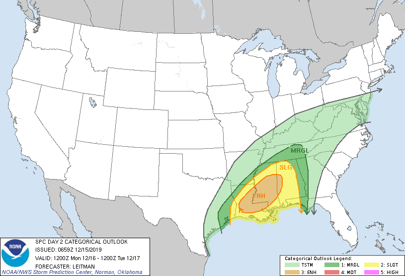
...THERE IS AN ENHANCED RISK OF SEVERE THUNDERSTORMS ACROSS PORTIONS
OF LA...SOUTHERN AND CENTRAL MS AND FAR WEST-CENTRAL AL...
...SUMMARY...
Scattered severe storms are expected Monday into Monday night from
the Sabine River Valley through Louisiana, Mississippi, Alabama and
the western Florida Panhandle. Damaging wind gusts, tornadoes and
isolated hail are all possible.
...Sabine Valley to the Gulf Coast States...
Forecast guidance continues to trend slightly southward with the
evolution of the mid/upper trough ejecting across the Plains on
Monday, as well as in the evolution of the surface low over the
lower MS Valley region. Latest guidance is in good agreement that a
weak low will develop over northern LA with an inverted trough
extending northeast across MS into TN/KY. The low will track
northeast along the trough/frontal wave the TN Valley vicinity
around 00z and the central Appalachians by 12z Tuesday. A trailing
cold front will push eastward across the lower MS Valley, located
from eastern TN to near Mobile AL and the western Gulf of Mexico by
the end of the period.
A strong southwesterly jet continues to be forecast, and 700 mb
winds around 40-55 kt will be in place across much of the South
Monday morning. An 850 mb low level jet around 35-50 kt also is
forecast to persist across the Gulf Coast states for much of the
period. Strong southerly low level flow will transport mid 60s F
dewpoints as far north as central MS/AL with 70s F dewpoints closer
to the coast. While cloud cover will limit stronger heating, this
rich boundary-layer moisture beneath 6.5-7.0 C/km lapse rates will
result in MLCAPE values from near 500-1500 J/kg. Furthermore,
impressive vertical shear will support rotating updrafts/supercells.
Some uncertainty in storm mode remains, as deep-layer flow above
around 1-2 km is generally parallel to the surface front, which
would generally support more linear and/or cluster storm modes.
However, some guidance shows considerable backing of low level winds
ahead of the front, resulting in rather large low level hodographs
and increased frontal convergence. If this scenario pans out, mixed
modes including bowing line segments/clusters and semi-discrete
supercells will be possible. Regardless of storm mode, damaging
winds appear likely given relatively fast storm motion and strong
flow in the presence of an adequate thermodynamic environment.
Tornadoes will also be possible, via mesovortex processes in line
segments, as well as with any discrete supercells that develop.
Finally, midlevel lapse rates are stronger than typical across the
region, which will aid in hail production with more isolated storm
modes.
Various guidance has indicated a secondary and/or later threat may
emerge over portions of southern AL toward the western FL Panhandle.
A lead impulse as been evident in the last several forecast cycles
and this could support convection well ahead of the cold front, or
aid in further development/persistence of severe storms from Monday
evening into the overnight hours. Uncertainty is higher in this
scenario compared to the rest of the outlook area, but the Slight
and Marginal risks have been shifted eastward to account for this
possibility.
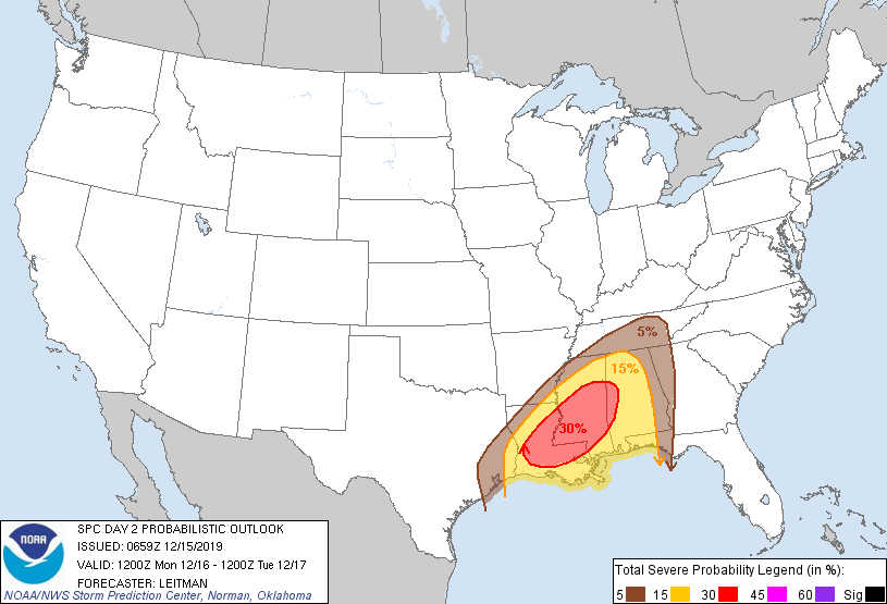
...MAXIMUM RISK BY HAZARD...
Tornado: 5% - Slight
Wind: 30% - Enhanced
Hail: 15% - Slight
..Leitman.. 12/15/2019
CLICK TO GET WUUS02 PTSDY2 PRODUCT
NOTE: THE NEXT DAY 2 OUTLOOK IS SCHEDULED BY 1730Z