New Orleans, LA...Montgomery, AL...Shreveport, LA...Mobile, AL...Columbus, GA...
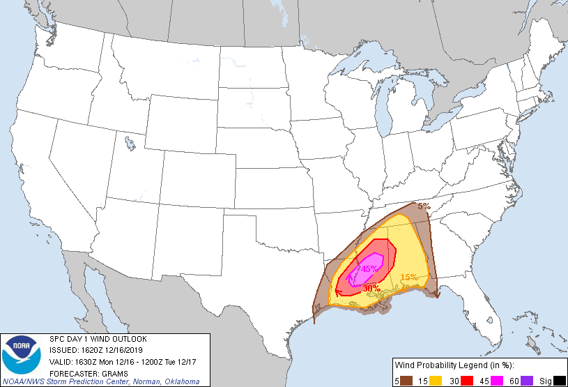
Probabilistic Damaging Wind Graphic
Probability of damaging thunderstorm winds or wind gusts of 50 knots or higher within 25 miles of a point. Hatched Area: 10% of greater probability of wind gusts 65 knots or greater within 25 miles of a point.
SPC AC 161620
Day 1 Convective Outlook
NWS Storm Prediction Center Norman OK
1020 AM CST Mon Dec 16 2019
Valid 161630Z - 171200Z
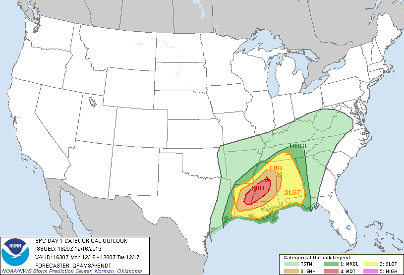
...THERE IS A MODERATE RISK OF SEVERE THUNDERSTORMS NORTHEAST LA TO
CENTRAL MS...
...SUMMARY...
Numerous to potentially widespread severe thunderstorms are
anticipated across parts of the Lower Mississippi Valley and Deep
South with tornadoes and damaging winds as the primary hazards. The
peak tornado risk is expected through early evening, centered on
northern and central Louisiana into central Mississippi.
...Lower MS Valley and Deep South...
Primary changes this outlook are to increase tornado and wind
probabilities across parts of LA/MS. In addition, the SLGT risk has
been expanded north for wind into middle TN near the expected
surface cyclone track.
Gradual expansion of surface-based thunderstorms is expected across
the Sabine and Lower MS Valleys, along/ahead of the surface cold
front. Activity should grow in coverage and move across the
Mid-South and MS/AL regions through this evening into tonight.
Several tornadoes will be possible across the entire region, but
with greatest potential in a corridor from northern/central LA
across central MS where semi-discrete supercells are most probable,
and should access the most favorable CAPE/shear parameter space.
Damaging gusts should be the most common convective event area-wide.
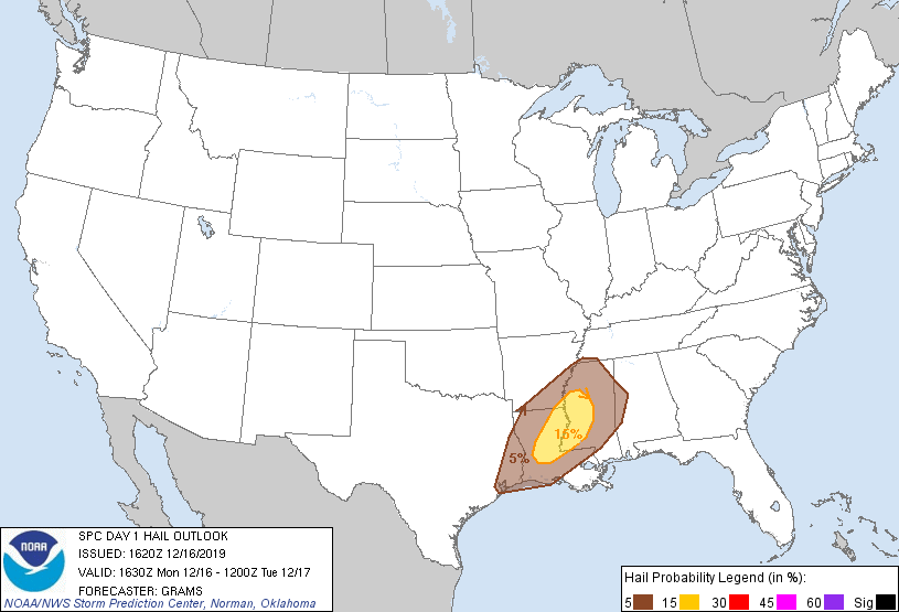
Severe hail is most probable over southwestern parts of the outlook
area, essentially collocated with greatest tornado probabilities.
12Z soundings sampled the pronounced elevated mixed layer overlying
the rich low-level moisture plume (characterized by upper 60s to low
70s surface dew points) emanating northeast from the western Gulf.
Abundant cloud coverage will be a limiting factor, but moderate
surface-based buoyancy characterized by MLCAPE of 1000-2000 J/kg
will persist in the ambient environment ahead of the front across LA
through parts of MS. Relatively backed surface winds, beneath a
40-60-kt southwesterly LLJ, will contribute to enlarged hodographs
and 300+ effective SRH.
Given potential for sustained warm-sector supercells, such as
progged by the HRRR, HRRR-P and WRF-ARW, such an environment will
support a risk for multiple significant tornadoes. Otherwise,
regardless of warm-sector convective density, a band of
thunderstorms should evolve close to the front and shift across the
remainder of the outlook area through the period. This activity will
offer a risk for numerous to widespread damaging winds and embedded
QLCS tornadoes. It will eventually encounter gradually weaker
low-level and mid-level lapse rates and less inflow-layer moisture
content with northeast/eastern extent. This should result in a
somewhat lesser threat for damaging winds and tornadoes tonight.
..Grams/Wendt.. 12/16/2019
CLICK TO GET WUUS01 PTSDY1 PRODUCT
NOTE: THE NEXT DAY 1 OUTLOOK IS SCHEDULED BY 2000Z