New Orleans, LA...Birmingham, AL...Montgomery, AL...Mobile, AL...Columbus, GA...
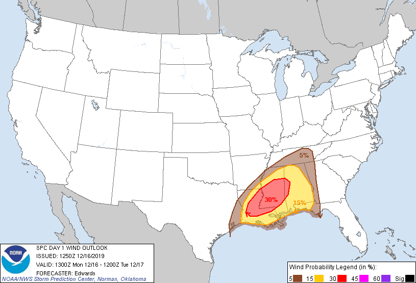
Probabilistic Damaging Wind Graphic
Probability of damaging thunderstorm winds or wind gusts of 50 knots or higher within 25 miles of a point. Hatched Area: 10% of greater probability of wind gusts 65 knots or greater within 25 miles of a point.
SPC AC 161250
Day 1 Convective Outlook
NWS Storm Prediction Center Norman OK
0650 AM CST Mon Dec 16 2019
Valid 161300Z - 171200Z
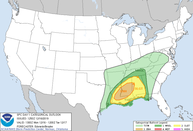
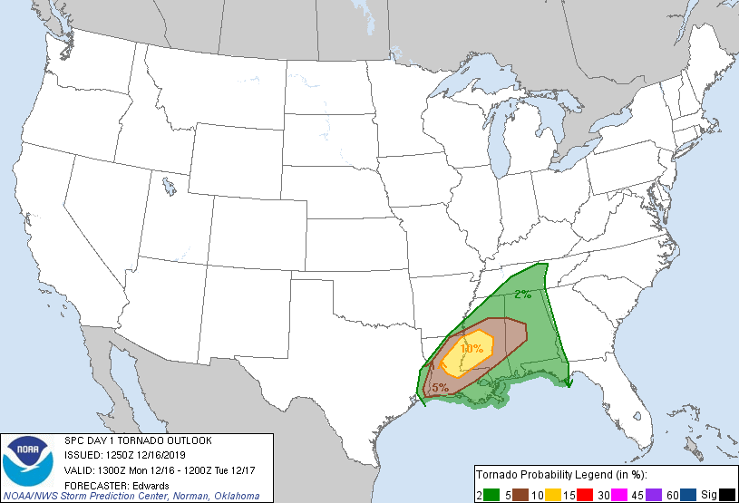
...THERE IS AN ENHANCED RISK OF SEVERE THUNDERSTORMS FROM CENTRAL
LOUISIANA TO WESTERN ALABAMA...
...SUMMARY...
Scattered severe thunderstorms may begin midday today over
Louisiana, peaking during the late afternoon/evening from northeast
Louisiana into central Mississippi. Tornadoes and damaging gusts
are the primary hazards. Activity should shift into into Alabama
and the Florida Panhandle this evening and overnight.
--- Technical Discussion ---
...Synopsis...
The mid/upper-level pattern over the CONUS will be dominated by
progressive, high-amplitude ridging -- moving inland from the West
Coast -- and broadly cyclonic flow downstream associated with a
complex troughing regime. A northern-stream shortwave trough --
emanating from the southwestern rim of a cyclone over the Canadian
Arctic region -- will dig southeastward across central Canada,
reaching northeastern MB, northwestern ON, and the Boundary Waters
area of MN by the end of the period. As this occurs, a separate
perturbation -- now evident in moisture-channel imagery over
portions of CO/NM -- will shift eastward across the southern/central
Plains. The northern portion will stretch northeastward overnight,
across the mid Mississippi Valley and Ozarks, in a field of
confluent 500-mb flow related to the approaching northern-stream
trough. The trailing/southwestern portion will phase with an
initially separate, weaker vorticity banner pivoting south-
southeastward from the northern Rockies.
By 12Z, these processes should result in a well-defined, positively
tilted synoptic trough from Lake Michigan across MO, OK and central
NM. Strong cyclonic flow will exist just southeast of this trough,
with a 120-130-kt 250-mb jet by 12Z located from west TX
northeastward up the Ohio Valley, atop a narrow, 85-95-kt 500-mb jet
core.
At the surface, 11Z analysis showed a cold front across portions of
WV, southeastern KY, middle TN, southeastern AR, east TX, and
south-central TX. This front will move southeastward to northern
GA, southeastern AL,the western FL Panhandle, and the north-central/
west-central Gulf through the period. A weak surface low analyzed
in the SHV-GGG area will propagate northeastward along the front and
intensify, reaching eastern WV by 12Z. A warm/marine front was
drawn from the AL coastline southeastward across the northeastern
Gulf to south FL and the northern Bahamas. This boundary will move
slowly northward through the period, while return flow spread
favorably higher theta-e inland to the west across LA/MS in support
of severe potential.
...Lower Mississippi Valley, Southeast...
Beginning late morning into early afternoon, development and gradual
strengthening/expansion of surface-based thunderstorms is forecast
along/ahead of the surface cold front -- initially over western/
southern parts of the outlook area. Activity should grow in
coverage and move across the Delta, Mid-South and MS/AL regions
through this evening into tonight. Tornadoes will be possible
across the entire region, but with greatest potential in a corridor
from central LA across central/eastern MS where supercells are most
probable, and may access the most favorable CAPE/shear parameter
space. Damaging gusts should be the most common convective event
area-wide. Severe hail is most probable over southwestern parts of
the outlook area -- essentially collocated with greatest tornado
probabilities and for much the same reason (potential for
supercells).
Surface-based buoyancy and low/middle-level lapse rates each should
be relatively maximized across the LA/MS part of the outlook. Rich
boundary-layer moisture (dew points commonly mid/upper 60s F,
locally low 70s) and diurnal surface heating will destabilize the
preconvective air mass through the afternoon. Meanwhile, a section
of EML air -- emanating from central/northern MX with 700-mb
temperatures in the 7-10 deg C range near the upper TX/LA coasts --
is well-sampled by the 12Z LCH RAOB. This plume will help to
maintain steep midlevel lapse rates, along with somewhat stronger
MLCINH near the immediate coastal areas of LA. Capping will erode
through the day, permitting convective growth/intensification in an
environment over central LA and MS characterized by 1000-2000 J/kg
MLCAPE, with 45-55-kt effective-shear magnitudes. Relatively backed
surface winds, beneath a 40-60-kt southwesterly LLJ, will contribute
to enlarged hodographs and 200-400 J/kg effective SRH.
Given sustained warm-sector supercells with little storm-scale
interference, such as progged by the sometimes overly aggressive
HRRR, such an environment can support significant/EF2+ tornadoes.
At this time, however, amount and longevity of relatively discrete
cells in the warm sector are still uncertain, especially given some
EML-driven capping, and flow aloft being largely parallel to the
primary corridor of forcing near the front. A hatched/significant
area may need to be added in an upcoming outlook if mesoscale
diagnostic trends and 12Z numerical guidance increase confidence in
multiple warm-sector supercells.
Otherwise, regardless of warm-sector convective density, a band of
thunderstorms should evolve close to the front and shift across the
remainder of the outlook area through the period. This activity
will encounter gradually weaker low-level and midtropospheric lapse
rates and less inflow-layer moisture content with northeastward and
eastward extent -- hence the tapering of severe probabilities in
those directions. Still, potential for scattered damaging winds and
a threat of tornadoes is evident. One relatively minor change made
to this package is to add more of the FL Panhandle to the outlook
for overnight. This is in deference to the potential for convection
to form over the Gulf or near the coast -- east of the
aforementioned EML plume in weaker CINH -- and move inland in
favorable CAPE and vertical wind profiles for supercells.
..Edwards/Broyles.. 12/16/2019
CLICK TO GET WUUS01 PTSDY1 PRODUCT
NOTE: THE NEXT DAY 1 OUTLOOK IS SCHEDULED BY 1630Z