Detroit, MI...Milwaukee, WI...Madison, WI...Grand Rapids, MI...Sioux Falls, SD...
MARGINAL
392,101
74,661,479
New York, NY...Chicago, IL...Philadelphia, PA...Baltimore, MD...Washington, DC...
Probabilistic Tornado Graphic
Probability of a tornado within 25 miles of a point. Hatched Area: 10% or greater probability of EF2 - EF5 tornadoes within 25 miles of a point.
Day 1 Tornado Risk
Area (sq. mi.)
Area Pop.
Some Larger Population Centers in Risk Area
5 %
26,706
106,190
Scottsbluff, NE...Torrington, WY...
2 %
91,361
12,458,511
Detroit, MI...Milwaukee, WI...Madison, WI...Grand Rapids, MI...Sioux Falls, SD...
Probabilistic Damaging Wind Graphic
Probability of damaging thunderstorm winds or wind gusts of 50 knots or higher within 25 miles of a point. Hatched Area: 10% of greater probability of wind gusts 65 knots or greater within 25 miles of a point.
Day 1 Wind Risk
Area (sq. mi.)
Area Pop.
Some Larger Population Centers in Risk Area
15 %
163,525
14,184,094
Detroit, MI...Milwaukee, WI...Madison, WI...Grand Rapids, MI...Sioux Falls, SD...
5 %
356,628
73,155,228
New York, NY...Chicago, IL...Philadelphia, PA...Baltimore, MD...Washington, DC...
Probabilistic Large Hail Graphic
Probability of hail 1" or larger within 25 miles of a point. Hatched Area: 10% or greater probability of hail 2" or larger within 25 miles of a point.
Omaha, NE...Minneapolis, MN...St. Paul, MN...Sioux Falls, SD...Fort Collins, CO...
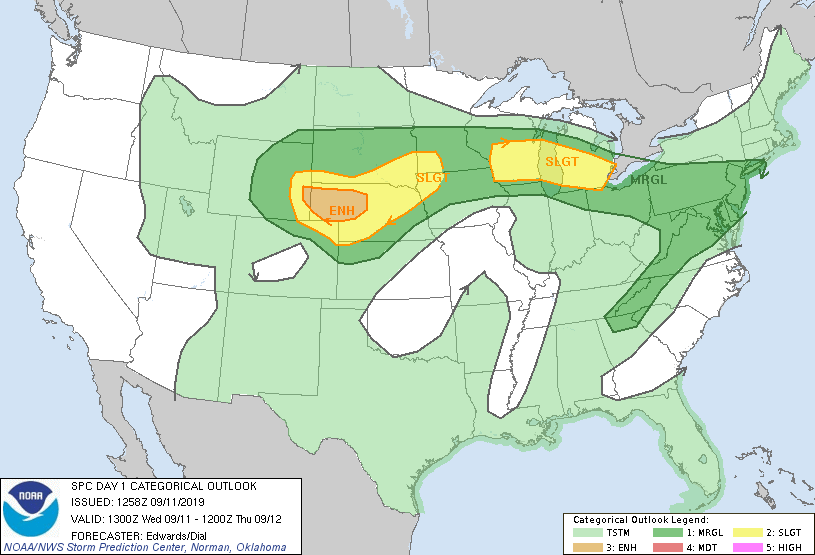
   SPC AC 111258

   Day 1 Convective Outlook
   NWS Storm Prediction Center Norman OK
   0758 AM CDT Wed Sep 11 2019

   Valid 111300Z - 121200Z

   ...THERE IS AN ENHANCED RISK OF SEVERE THUNDERSTORMS TODAY INTO THIS
   EVENING OVER PARTS OF THE CENTRAL HIGH PLAINS...

   ...THERE IS A SLIGHT RISK OF SEVERE THUNDERSTORMS TODAY INTO THIS
   EVENING FROM PORTIONS OF WISCONSIN ACROSS PARTS OF LOWER MICHIGAN...

   ...SUMMARY...
   The greatest severe-storm risk is today into this evening over parts
   of the central High Plains, where large, damaging hail and severe
   gusts are expected, and a few tornadoes are possible.

   ...Synopsis...
   A progressive westerly wave train will characterize the general
   upper-air pattern over the northern 1/2-2/3 of the CONUS this
   period.  the main feature aloft aiding severe potential will be a
   synoptic-scale trough -- initially evident in moisture-channel
   imagery over western MT, ID, eastern NV, and the lower Colorado
   River Valley.  This trough will move to an axis near GTF-JAC-PGA by
   00Z, and GGW-CDR-ALS by 12Z, with an intermittently closed 500-mb
   low shifting eastward across MT.  To its east, an MCV is noted in
   midlevel satellite imagery and composited radar loops over eastern
   MN, with shortwave trough southward over southern MN.  This
   perturbation should proceed eastward across WI, Lake Michigan, and
   part of northern Lower Michigan through this evening.

   At the surface, the 11Z analyses showed a wavy, mostly stationary
   front from Lake Ontario across southern Lower MI and southern WI, to
   a low near LSE, then west-southwestward across southeastern SD and
   northwestern NE, behind some convective outflow.  The outflow
   boundary extended across northeastern/central IA and south-central
   NE near I-80.  An elongated low-pressure area was located from
   southeastern WY across eastern CO.  The low-pressure area should
   consolidate through the day, then shift roughly northeastward across
   NE overnight, reaching the FSD vicinity by 12Z.  A cold front will
   sweep southward/southeastward across the central Great Plains behind
   that low, reaching east-central NE, north-central/southwestern KS
   and the Raton Mesa area by 12Z.

   The eastern frontal segment should settle somewhat southward across
   the mid-Atlantic region, but remain quasistationary from there to
   near the Mississippi River, modulated on the mesoscale by MCS
   outflow over the southern Upper Great Lakes region.  The combined
   front/outflow boundary also should move slowly northward as a warm
   front ahead of that low tonight over eastern NE/IA.

   ...Central Plains...
   Scattered thunderstorms, including a few supercells, are forecast to
   form over higher terrain of eastern WY as early as midday to early
   afternoon, in the presence of strengthening deep-layer forcing that
   precedes the mid/upper trough.  This activity should move generally
   eastward across the NE Panhandle/Sandhills regions, and perhaps
   adjoining parts of southern SD, offering the threat for all forms of
   severe.

   The most supportive parameter space may develop over portions of
   west-central NE, where rich low-level moisture should advect into
   the region.  This will be most pronounced along and south of the
   northward-moving outflow boundary merging with the synoptic front --
   in the eastern sector of the low-level cyclogenesis and associated
   mass response to the approaching synoptic trough.  Favorable mid/
   upper-level lapse rates and a deeply buoyant troposphere overlying
   that moisture, in combination with diabatic surface heating, will
   contribute to MLCAPE in the 2000-3500 J/kg range.  Veering low-level
   winds with height will contribute to favorable deep shear (e.g., 40-
   50-kt effective-shear magnitudes), though lack of stronger speeds in
   low levels may temper hodograph size somewhat away from mesobeta- to
   local-scale boundary influences.  Still, with the boundary and
   supercell-favorable bulk shear, a tornado risk does exist, along
   with the potential for very large/damaging hail of 2 inches or
   larger in diameter.

   Another upscale-growth process is forecast to evolve from the early
   supercell and multicell activity, amidst general height falls and
   increasing large-scale forcing for ascent that precedes the
   progressive mid/upper trough.  This should result in an evening/
   overnight MCS sweeping into a recovering air mass located from
   central/northeastern NE into the Siouxland area.  Damaging and
   severe gusts will be the main concern once the MCS develops, though
   brief/embedded QLCS mesovortices may develop for an isolated threat
   of tornadoes.

   ...Upper Great Lakes region...
   Isolated strong-severe gusts cannot be ruled out the next few hours
   from the MCS crossing the upper Mississippi Valley, particularly in
   the warm sector and very near the front on the north side, with
   increasing static stability in the boundary layer reducing that
   potential northward across western WI and Lake Michigan.  MCS
   outflow has stabilized much of the boundary layer in the original
   outlook area(s) across IA, rendering unconditional severe potential
   marginal in nature and skewed toward late in the period, as the
   outflow/frontal zone moves back northward.

   A continuation of the MCS and/or additional convective development
   near the front/outflow boundary will pose a greater threat of severe
   from midday through at least early evening, shifting eastward to
   east-southeastward across the eastern "slight risk" area.  Damaging
   gusts will be the main concern, though supercell-favorable kinematic
   fields will exist near the boundary, compelling marginal tornado/
   hail lines for part of the region.  The low-level air mass in the
   baroclinic zone and south of the surface boundary will destabilize
   today from a combination of thetae advection and pockets of
   sustained diabatic surface heating.  This will boost boundary-layer
   lapse rates and overall buoyancy amidst favorable moisture.  Surface
   dew points in the upper 60s to lower 70s F and PW around 1.75 inch
   should be common along and south of the preconvective frontal zone
   today, contributing to 1500-2500 J/kg MLCAPE.  30-40-kt effective-
   shear magnitudes and somewhat enlarged low-level hodographs (with
   200-300 J/kg effective SRH near the boundary) are possible, despite
   the area's being under the upper ridge.

   ..Edwards/Dial.. 09/11/2019

   CLICK TO GET WUUS01 PTSDY1 PRODUCT

   NOTE: THE NEXT DAY 1 OUTLOOK IS SCHEDULED BY 1630Z