The SPC is forecasting ...Severe thunderstorms expected over parts of the Upper Midwest this afternoon and tonight....
Please read
the latest public statement about this event. View What is a Watch? clip.
Categorical Graphic
Day 1 Risk
Area (sq. mi.)
Area Pop.
Some Larger Population Centers in Risk Area
MODERATE
28,318
1,350,460
Eau Claire, WI...St. Cloud, MN...Wausau, WI...Andover, MN...Stevens Point, WI...
ENHANCED
57,202
4,901,024
Minneapolis, MN...St. Paul, MN...Green Bay, WI...Bloomington, MN...Plymouth, MN...
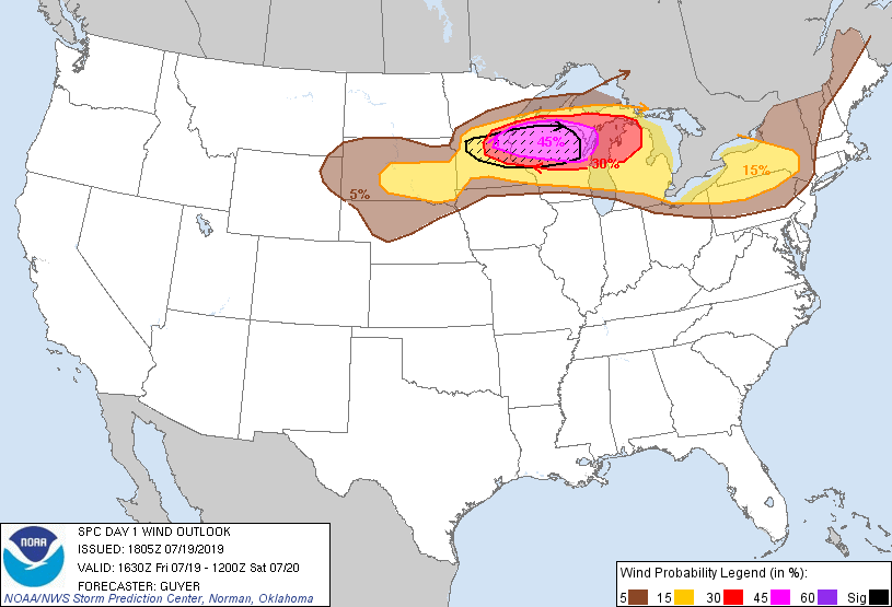
Probability of damaging thunderstorm winds or wind gusts of 50 knots or higher within 25 miles of a point. Hatched Area: 10% of greater probability of wind gusts 65 knots or greater within 25 miles of a point.
Day 1 Wind Risk
Area (sq. mi.)
Area Pop.
Some Larger Population Centers in Risk Area
SIG SEVERE
39,914
4,678,611
Minneapolis, MN...St. Paul, MN...Bloomington, MN...Plymouth, MN...Brooklyn Park, MN...
45 %
35,144
1,647,412
Green Bay, WI...Eau Claire, WI...Wausau, WI...Andover, MN...Stevens Point, WI...
   SPC AC 191805

   Day 1 Convective Outlook RESENT 2
   NWS Storm Prediction Center Norman OK
   0105 PM CDT Fri Jul 19 2019

   Valid 191630Z - 201200Z

   ...THERE IS A MODERATE RISK OF SEVERE THUNDERSTORMS ACROSS
   EAST-CENTRAL MINNESOTA AND NORTHERN WISCONSIN...

   CORRECTED FOR MODERATE RISK LINE/RETRANSMISSION

   ...SUMMARY...
   A regional outbreak of severe thunderstorms with the possibility of
   strong tornadoes and widespread significant wind damage is expected
   from central Minnesota across northern Wisconsin during the mid/late
   afternoon into tonight.

   ...Upper Midwest/Great Lakes...
   A regional outbreak of severe thunderstorms is expected later this
   afternoon into tonight. That said, some specific uncertainties
   remain with the timing details/exact sub-regional corridor of peak
   severe-weather risk given capping/warm temperatures aloft and
   uncertainty with the decay of the cloud shield from the earlier MCS
   across South Dakota.

   A very strong summertime belt of westerlies exists across the
   northern tier of the CONUS, with 50-100 kt westerlies noted between
   500/250 MB in 12Z upper-air data spanning Montana to the
   Dakotas/Minnesota. Where storms develop/increase later today, this
   very strong belt of winds aloft will be influential in storm
   organization including supercells and potential evolution of a
   fast-moving MCS (possible if not likely derecho) later
   today/tonight.

   Consult Mesoscale Discussion 1523 regarding midday details across
   western Minnesota. Additional surface-based thunderstorm development
   may emanate from the ascent/differential heating related to the MCS
   remnants, focusing downstream surface-based severe potential across
   central Minnesota. An extremely unstable air mass (MLCAPE >4000
   J/kg) will continue to become established from southeast Southeast
   South Dakota through central/southern Wisconsin as the elevated
   mixed-layer overspreads surface dew points rising into the mid to
   upper 70s. A surface cyclone over central South Dakotas should track
   towards the Twin Cities through early evening. Strong low-level
   convergence near/northeast of this cyclone along the warm front
   should sustain surface-based storm development across central into
   east-central Minnesota.

   Intense supercells are likely to develop rapidly, with an attendant
   threat for all severe hazards including the possibility of a strong
   tornado or two amid 50-60 kt effective shear and 0-3 km SRH >300
   m2/s2. The very warm/moist thermodynamic profiles will also support
   generation of strong cold pools which should eventually yield a
   bowing, forward-propagating MCS across northern Wisconsin into parts
   of northern Lower and Upper Michigan. Strength of the vertical shear
   suggests the potential for intense bowing segments capable of
   yielding a derecho with significant/widespread severe wind gusts.

   ...Lower Great Lakes/Northeast States...
   Have upgraded parts of the region for thunderstorm-wind related
   potential this afternoon into evening. This will be related to the
   possible east-southeastward persistence of a complex of storms
   across Ontario and additional scattered development that is expected
   in the lee of the Lower Great Lakes. The ambient air mass will be
   moderately to strongly unstable but the region will generally be
   south of the stronger westerlies aloft. The overall expectation is
   for predominantly multicellular, outflow-dominant storms capable of
   isolated damaging wind gusts this afternoon and evening.

   ...South Dakota tonight...
   Another round of 700-mb warm/moist advection will occur tonight
   within a tight baroclinic zone well north of a surface front arcing
   across Nebraska into northeast Wyoming. Large elevated buoyancy and
   strong effective shear will support a risk for isolated large hail.
   While storms will generally tend to be elevated, there may be some
   wind damage potential if upscale quasi-linear growth occurs late
   tonight as storms progress east-southeastward across South Dakota.

   ..Guyer/Wendt.. 07/19/2019

   CLICK TO GET WUUS01 PTSDY1 PRODUCT

   NOTE: THE NEXT DAY 1 OUTLOOK IS SCHEDULED BY 2000Z