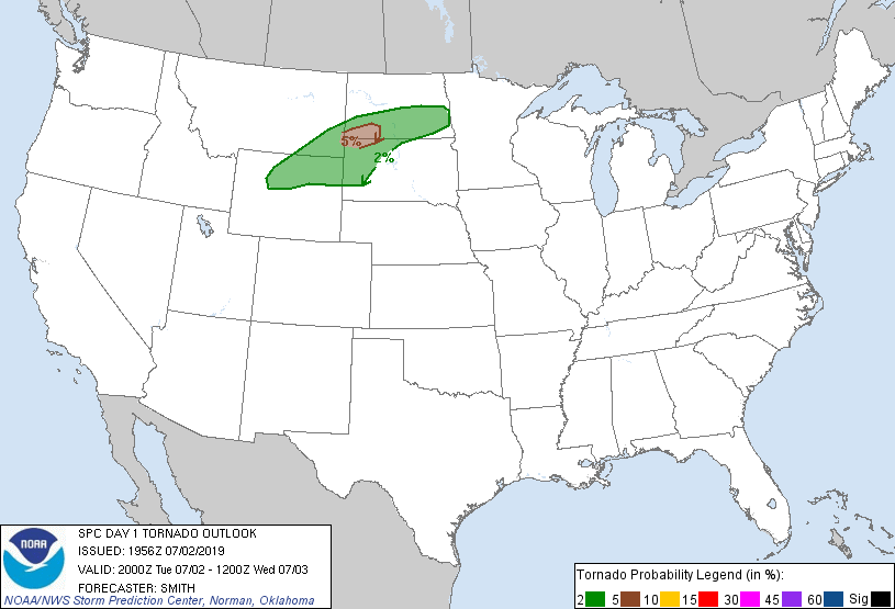
Probability of a tornado within 25 miles of a point. Hatched Area: 10% or greater probability of EF2 - EF5 tornadoes within 25 miles of a point.
Day 1 Tornado Risk
Area (sq. mi.)
Area Pop.
Some Larger Population Centers in Risk Area
5 %
7,817
12,321
No Major Population Center in Risk Area
2 %
73,073
562,727
Rapid City, SD...Bismarck, ND...Gillette, WY...West Fargo, ND...Mandan, ND...
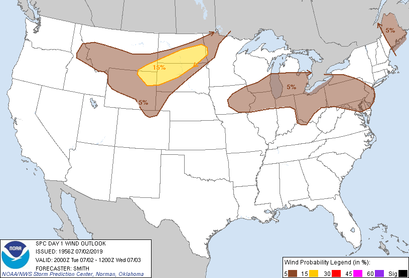
Probabilistic Damaging Wind Graphic
Probability of damaging thunderstorm winds or wind gusts of 50 knots or higher within 25 miles of a point. Hatched Area: 10% of greater probability of wind gusts 65 knots or greater within 25 miles of a point.
Day 1 Wind Risk
Area (sq. mi.)
Area Pop.
Some Larger Population Centers in Risk Area
15 %
74,216
666,459
Fargo, ND...Rapid City, SD...Bismarck, ND...Moorhead, MN...Gillette, WY...
Billings, MT...Fargo, ND...Rapid City, SD...Bismarck, ND...Moorhead, MN...
5 %
199,684
2,345,154
Fort Collins, CO...Greeley, CO...Missoula, MT...Loveland, CO...Cheyenne, WY...
SPC AC 021956
Day 1 Convective Outlook
NWS Storm Prediction Center Norman OK
0256 PM CDT Tue Jul 02 2019
Valid 022000Z - 031200Z
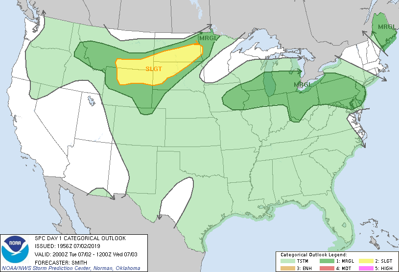
...THERE IS A SLIGHT RISK OF SEVERE THUNDERSTORMS FOR PARTS OF
SOUTHERN MT/NORTHERN WY TO THE DAKOTAS...
...SUMMARY...
The most likely region for scattered severe thunderstorms is from
parts of southern Montana and northern Wyoming east-northeast into
parts of the Dakotas. The greatest potential for a couple tornadoes
exists across southwest North Dakota and northwest South Dakota.
Otherwise, large hail and severe wind gusts are possible this
afternoon into the overnight.
...Discussion...
Only 1 minor change was made to the previous outlook. Included the
eastern IN/southwest OH vicinity in 5-percent wind probabilities
based in part on measured severe gusts and an unstable airmass
located downstream of the active thunderstorms in this general area.
..Smith.. 07/02/2019
.PREV DISCUSSION... /ISSUED 1128 AM CDT Tue Jul 02 2019/
...Northern Rockies/High Plains to Dakotas...
A shortwave trough over western OR/WA will drift eastward yielding
weak downstream height falls across the northern Rockies/adjacent
High Plains amid a belt of 30-50 kt 500-mb southwesterlies. A cold
front from northeast ND to far southern MT will stall as surface
cyclogenesis ensues in the lee of the Big Horns in northeast
Wyoming.
12Z soundings ahead of the front sampled relatively modest
boundary-layer moisture for early July, but persistent southeasterly
low-level winds should maintain surface dew points in the upper 50s
to lower 60s at peak heating near the WY/MT/SD/ND border region.
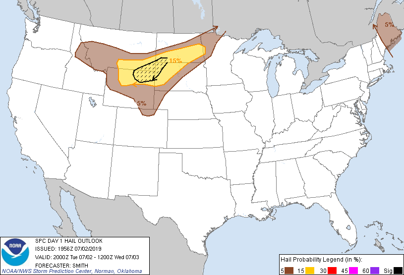
Beneath a plume of steep mid-level lapse rates, a corridor of MLCAPE
from 1500-2500 J/kg is anticipated ahead of the cyclone along the
front. Deep-layer shear will be maximized in this same corridor,
with 35-45 kt effective values supportive of supercells as storms
develop from mid-afternoon into this evening. Multiple areas of
initiation are anticipated, but the most likely corridor for
persistent supercells is from the Big Horn Basin into northwest
SD/southwest ND.
Large hail will likely be the primary risk during the late afternoon
to early evening. Tornado potential should be maximized near the
southwest ND/northwest SD border region just northeast of the lee
cyclone where surface winds are backed. Consolidation into clusters
or a broader MCS is probable as a moderate southerly low-level jet
develops. This may yield a predominant risk for severe wind during
the evening eastward along the ND/SD border region, with this threat
likely waning overnight.
...Mid-Atlantic States to Midwest...
Scattered thunderstorms are expected during mid afternoon to early
evening from NJ/PA westward across the Lower Great Lakes into IA.
This activity should be focused near a pair of MCVs moving
east-southeast from far southern Lake Ontario and northern Lake MI,
along with the presence of a weak front/wind shift. Greater buoyancy
should be displaced south/southwest from modestly enhanced mid-level
flow to the north/northeast. As a result, storm organization should
be limited to loosely organized multicells with effective shear
generally less than 25 kt. Locally damaging winds will be the
primary hazard.
...Central/eastern Maine...
Isolated thunderstorms have initiated within an environment
characterized by an elongated hodograph amid strong deep-layer speed
shear. However, weak mid-level lapse rates to the south of a
vorticity maximum sliding southeast towards the Canadian Maritimes
will be a limiting factor to more robust updraft strength. As such,
locally damaging winds and marginally severe hail should be the most
likely hazards. See MCD 1339 for additional short-term information.
CLICK TO GET WUUS01 PTSDY1 PRODUCT
NOTE: THE NEXT DAY 1 OUTLOOK IS SCHEDULED BY 0100Z