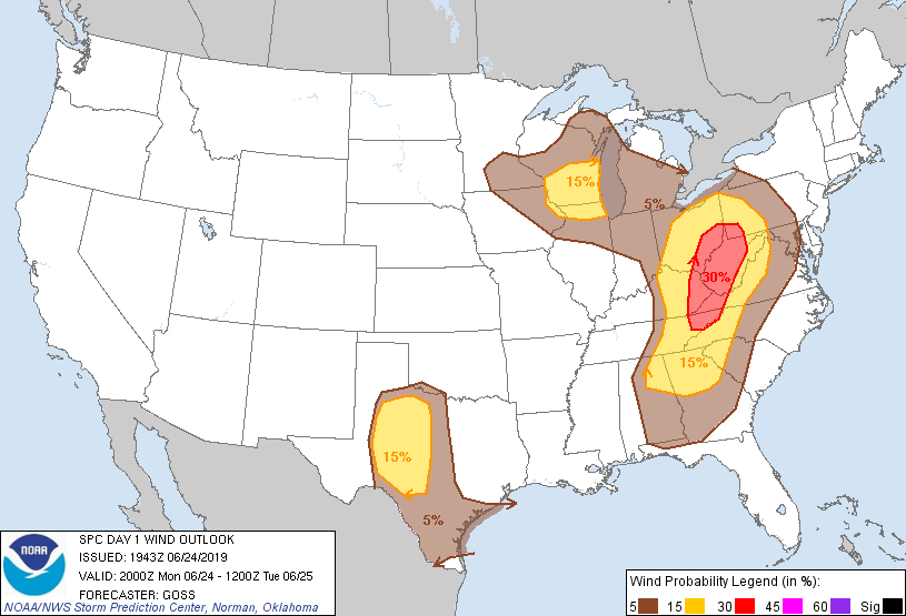
Probability of damaging thunderstorm winds or wind gusts of 50 knots or higher within 25 miles of a point. Hatched Area: 10% of greater probability of wind gusts 65 knots or greater within 25 miles of a point.
Day 1 Wind Risk
Area (sq. mi.)
Area Pop.
Some Larger Population Centers in Risk Area
30 %
43,228
4,319,539
Johnson City, TN...Charleston, WV...Huntington, WV...Kingsport, TN...Mount Lebanon, PA...
San Antonio, TX...Detroit, MI...Indianapolis, IN...Columbus, OH...Austin, TX...
SPC AC 241943
Day 1 Convective Outlook
NWS Storm Prediction Center Norman OK
0243 PM CDT Mon Jun 24 2019
Valid 242000Z - 251200Z
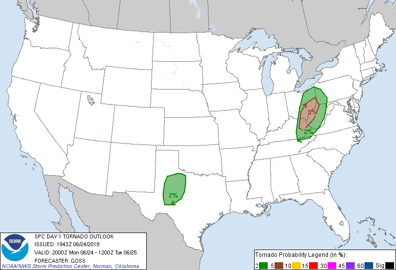
...THERE IS AN ENHANCED RISK OF SEVERE THUNDERSTORMS FROM THE UPPER
OHIO VALLEY AREA SOUTHWARD TO THE NORTHEAST TENNESSEE AREA...
...THERE IS A SLIGHT RISK OF SEVERE THUNDERSTORMS SURROUNDING THE
ENH RISK AREA...ACROSS PORTIONS OF WEST-CENTRAL TEXAS...AND OVER THE
SOUTHERN WISCONSIN/NORTHERN ILLINOIS VICINITY...
...SUMMARY...
Scattered strong to severe storms capable of damaging winds will
continue to evolve over the central/southern Appalachians and Ohio
Valley today. Other more isolated severe activity may yet occur
over northern Illinois/southern Wisconsin and vicinity, and is
expected to develop in the next couple of hours over
west-central/southwest Texas.
...Discussion...
Convection continues to evolve this afternoon as anticipated; with
reasoning communicated in prior outlooks still appearing valid at
this time, no outlook changes are needed.
..Goss.. 06/24/2019
.PREV DISCUSSION... /ISSUED 1105 AM CDT Mon Jun 24 2019/
...Central/Southern Appalachians...
Morning satellite and radar imagery show a well-defined remnant MCV
over southern KY. This trough is embedded with a larger upper
trough rotating across the OH/TN valleys. The air mass ahead of the
feature is heating rapidly and will become very unstable by
mid-afternoon. Strengthening midlevel winds, coupled with strong
instability and affects of the MCV will pose a more substantial risk
of bowing thunderstorm structures capable of damaging wind gusts. A
few supercells cannot be ruled out, along with a risk of isolated
tornadoes. Therefore have upgraded much of WV and vicinity to an
ENH risk and 30% severe wind probabilities.
...AL/GA...
A very warm/humid air mass remains in place today over this region
with strong CAPE values expected. Most 12z CAM solutions suggest
pockets of afternoon thunderstorm development, although models
differ on placement and timing. Those storms that form will pose a
risk of strong/damaging wind gusts.
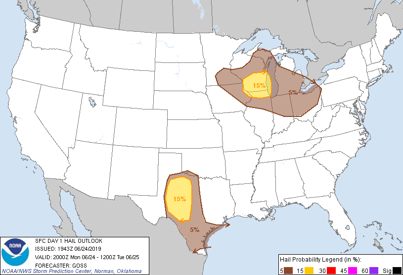
...WI/IL...
Considerable cloud cover is slowly eroding today from the west over
southern WI/northern IL. This may result in sufficient afternoon
heating for scattered thunderstorm development. Relatively cold
midlevel temperatures and dewpoints in the 60s will promote a few
robust updrafts capable of hail. Vertical shear is not particularly
strong - and given the clouds and thermodynamic uncertainties,
overall coverage of severe storms may remain limited.
...TX...
Full sunshine and rapid destabilization is occurring over parts of
west TX today. This is expected to result in rapid thunderstorm
development this afternoon. Large CAPE values will be in place, but
vertical shear will be weak. It appears that multicell storm
structures will be common, with gusty winds and hail possible in the
most intense cores.
CLICK TO GET WUUS01 PTSDY1 PRODUCT
NOTE: THE NEXT DAY 1 OUTLOOK IS SCHEDULED BY 0100Z