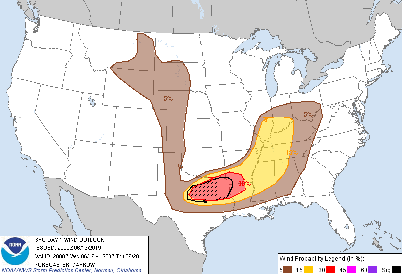
Probability of damaging thunderstorm winds or wind gusts of 50 knots or higher within 25 miles of a point. Hatched Area: 10% of greater probability of wind gusts 65 knots or greater within 25 miles of a point.
   SPC AC 192000

   Day 1 Convective Outlook
   NWS Storm Prediction Center Norman OK
   0300 PM CDT Wed Jun 19 2019

   Valid 192000Z - 201200Z

   ...THERE IS AN ENHANCED RISK OF SEVERE THUNDERSTORMS ACROSS
   NORTH-CENTRAL TX TO THE ARKLATEX...

   ...THERE IS A SLIGHT RISK OF SEVERE THUNDERSTORMS FROM WEST-CENTRAL
   TX TO SOUTHERN IN...

   ...SUMMARY...
   Numerous severe thunderstorms are expected to develop by late
   afternoon across north-central/northeast Texas. Very large hail and
   severe wind gusts are expected. Other isolated severe storms are
   expected from western Tennessee into southern Indiana.

   ...North-central TX/Arklatex...

   Note: Some consideration was given to raising severe probs (MDT)
   across north-central TX. Very large hail and severe wind gusts are
   expected with convection into the late evening.

   Strong boundary-layer heating has developed across west TX into the
   DFW Metroplex where surface temperatures have risen into the mid
   90s. This has resulted in a very unstable air mass along southern
   fringe of influential short-wave trough that will eject into AR this
   evening. 19z sounding from FWD is quite impressive with PW values
   >1.6", 40kt surface-6km shear, and steep lapse rates. Latest
   satellite imagery suggests a festering cumulus field just south of
   the Red River and thermals are expected to gradually deepen over the
   next few hours. Scattered supercells will develop and propagate
   east-southeast this evening through the Metroplex and northeast TX.
   Very large hail and damaging winds are expected. One or two
   tornadoes could be noted with discrete activity before clustering
   leads to a potential MCS this evening.

   ..Darrow.. 06/19/2019

   .PREV DISCUSSION... /ISSUED 1143 AM CDT Wed Jun 19 2019/

   ...North-central/northeast TX and southeast OK/ArkLaTex...
   In the wake of a decaying MCS across the Lower Mississippi River
   Valley, a northwestward-extending outflow boundary will continue to
   modify/drift northward with rapid/strong destabilization this
   afternoon particularly along and south of it. A quick
   reestablishment of lower/some middle 70s F surface dewpoints will
   occur into prior-MCS-impacted areas, with MLCAPE in excess of 4000
   J/kg expected for parts of north-central/northeast Texas into far
   southeast Oklahoma and the nearby ArkLaTex. Special 19Z observed
   soundings are expected from Fort Worth/Shreveport to help better
   gauge/confirm this destabilization trend and the degree of capping.

   By late afternoon, ascent should increase downstream of a minor
   mid-level impulse that is currently approaching from the southern
   Rockies. This should aid in convective initiation along the outflow
   boundary, as well as near the dryline bulge in the Texas Big
   Country. 40-50 kt effective shear with pronounced speed shear in the
   mid to upper-levels will support a risk for very large hail with
   initial supercells. The tornado risk should be maximized during the
   first couple hours of supercell formation in a relatively narrow
   corridor near the outflow boundary, where the influence of the
   boundary and strong instability will somewhat compensate for
   modest-strength low-level winds. With time, this activity should
   consolidate into another southeastward-moving MCS during the
   evening, aided by a strengthening southwesterly low-level jet, with
   an increasing threat for severe wind gusts, a few of which could be
   significant given the large buoyancy and ample shear by mid-June
   standards.

   ...Ohio/Tennessee Valleys and Mid-South...
   Regarding the Ohio Valley, for short-term details see Mesoscale
   Discussion 1133. An MCV-related enhanced belt of
   low/mid-tropospheric flow will shift eastward across these regions
   through the afternoon and evening, with the strongest
   destabilization expected this afternoon along and south of the Ohio
   River. Gradually increasing vertical shear will commonly support
   multicells, along with some supercells, capable of damaging
   winds/hail and possibly a tornado risk.

   ...Northern High Plains...
   A shortwave trough will amplify from British Columbia across the
   northern Rockies as a 50-60 kt mid-level jet spreads east across the
   Northwest. This will strengthen forcing for ascent and yield
   sustained thunderstorm development by late afternoon along the
   Wyoming/Montana border and in eastern Montana. While boundary-layer
   moisture will be limited and the boundary layer will not be
   particularly warm, increasingly elongated hodographs will favor
   potential for splitting supercells, a couple of which could be long
   tracked. This would particularly be across northern Wyoming into
   western South Dakota, where a swath of severe hail with localized
   severe wind gusts appears possible.

   CLICK TO GET WUUS01 PTSDY1 PRODUCT

   NOTE: THE NEXT DAY 1 OUTLOOK IS SCHEDULED BY 0100Z