Columbus, OH...Oklahoma City, OK...Tulsa, OK...Wichita, KS...Cincinnati, OH...
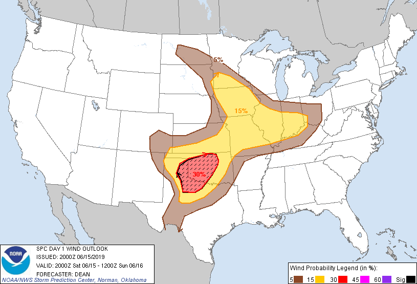
Probabilistic Damaging Wind Graphic
Probability of damaging thunderstorm winds or wind gusts of 50 knots or higher within 25 miles of a point. Hatched Area: 10% of greater probability of wind gusts 65 knots or greater within 25 miles of a point.
Day 1 Wind Risk
Area (sq. mi.)
Area Pop.
Some Larger Population Centers in Risk Area
SIG SEVERE
51,846
2,248,730
Oklahoma City, OK...Norman, OK...Wichita Falls, TX...Lawton, OK...Edmond, OK...
30 %
53,360
2,249,849
Oklahoma City, OK...Norman, OK...Wichita Falls, TX...Lawton, OK...Edmond, OK...
15 %
291,062
23,605,004
Indianapolis, IN...Kansas City, MO...Tulsa, OK...Wichita, KS...St. Louis, MO...
SPC AC 152000
Day 1 Convective Outlook
NWS Storm Prediction Center Norman OK
0300 PM CDT Sat Jun 15 2019
Valid 152000Z - 161200Z
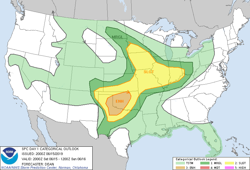
...THERE IS AN ENHANCED RISK OF SEVERE THUNDERSTORMS ACROSS PARTS OF
THE SOUTH CENTRAL PLAINS...
...SUMMARY...
One or two clusters of thunderstorms may be accompanied by hail and
swaths of strong, potentially damaging wind gusts this evening
across parts of the Texas Panhandle and northwest Texas into western
and northern Oklahoma. Additional strong to severe thunderstorms
are possible late this afternoon and evening across parts of the
middle Missouri, middle Mississippi and lower Ohio Valleys.
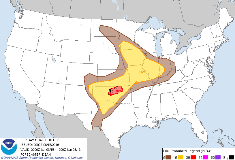
Two notable changes have been made for the 20Z outlook:
1. A small 30% hail area and hatched (10% significant hail) area has
been added for portions of northern OK. Guidance is in generally
good agreement that storms will form along a surface boundary by
early evening as the low-level jet gradually increases and a
vorticity maximum approaches from the west. While effective shear
will only be marginally supportive of organized convection, very
steep midlevel lapse rates and strong to extreme buoyancy will
support a conditional very large hail risk within 1-2 hours of
initiation, before consolidating outflows result in a more linear
storm mode.
2. Portions of extreme eastern NE and far western IA have been
removed from the Slight Risk, due to passage of a surface boundary
and stabilizing effects of midlevel cloudiness. Convection still
cannot be entirely ruled across this area, and Marginal Risk remains
in place for now.
Otherwise, no significant changes have been made to the outlook. See
the previous discussion below, and MCDs 1071-1073, for more
information.
..Dean.. 06/15/2019
.PREV DISCUSSION... /ISSUED 1128 AM CDT Sat Jun 15 2019/
...Synopsis...
Seasonably strong westerlies appear likely to remain confined to
northern portions of the Great Lakes region into the Northeast
during this period, on the southern periphery of a fairly deep
lower/mid tropospheric cyclone migrating across western through
northern Quebec. In response to this development, the center of a
broader scale mid-level low appears likely to gradually shift east
of James Bay.
In the wake of this feature, generally weak, broadly confluent,
northwesterly to westerly mid/upper level flow will prevail across
much of the U.S., but a belt of stronger flow appears likely to
linger across parts of the middle Mississippi into Ohio Valleys,
associated with an eastward propagating, convectively generated or
enhanced speed maximum (including 40-50+ kt at 500 mb).
Due to a prior intrusion of seasonably dry/cool air, seasonably
moderate to high boundary layer moisture content remains largely
confined to the interior U.S. to the west/southwest of the more
strongly confluent regime into the Canadian mid-level low. But,
elevated layers of steep lower/mid tropospheric lapse rates,
emanating from prior days strong daytime heating and mixing across
the high Plains and Intermountain West/Rockies, are expected to
contribute to moderate to large potential instability. This may
extending over a rather broad area of the central and southern
Plains through the middle and lower Missouri and Mississippi
Valleys. However, largest CAPE and steepest lower/mid tropospheric
lapse rates will remain focused beneath the residual plume of
warmest (and still potentially strongest capping) elevated mixed
layer air across the southern Plains.
This instability will provide potential for scattered strong to
severe thunderstorm development today into tonight. The most
substantive of this potential may become focused with a remnant
mesoscale convective vortex migrating into the lower Ohio Valley, a
developing area of large-scale ascent across parts of southern
Minnesota into Iowa, and perhaps most prominently with a
low-amplitude short wave trough approaching the southern Plains.
...Southern Plains...
Models indicate that a relatively focused area of weak to modest
mid-level height falls will overspread the Texas Panhandle through
much of western/northern Oklahoma this evening into the overnight
hours, associated with a low-amplitude short wave trough emerging
from the Southwest. While this area still appears likely to be
under the influence of the warm and capping elevated mixed-layer
air, associated forcing for ascent is expected to be sufficient to
maintain and support additional vigorous thunderstorm development.
Convective evolution remains at least somewhat uncertain, but models
suggest that thunderstorms may initiate across the Sangre de Cristo
Mountains and Raton Mesa area this afternoon, and eventually along
the dryline, near a broad surface low over the Texas South Plains.
Aided by the mid-level forcing, this activity is expected to
eventually consolidate and/or grow upscale, while spreading east of
the higher Plains.
Although deep layer mean wind fields and shear likely will be
initially weak, thermodynamic profiles appear supportive of
relatively cold convective outflow with potential for producing
strong surface gusts. This potential may increase through the
evening, aided by modest southerly 850 mb jet strengthening, along
the gust front of consolidating surface cold pools.
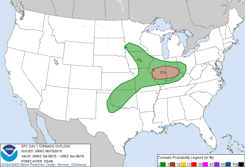
...Middle Mississippi into lower Ohio Valleys...
Severe weather potential remains a little unclear, and may
considerably hinge on the extent of insolation near a remnant
outflow boundary, generally east/southeast of the St. Louis metro
through portions of southern Illinois and Indiana, toward the
Cincinnati area. Boundary layer moisture is initially modest across
this region, but moistening appears underway, as the remnant MCV
(currently just west of St. Louis) progresses eastward. It is
possible that strengthening wind fields/shear and destabilization
near this boundary may contribute to an environment conducive to
supercells that could pose a risk for tornadoes by late this
afternoon or evening.
...Middle Missouri into middle Mississippi Valley...
Forcing for ascent near a weak frontal wave (on the southern
periphery of a low amplitude short wave progressing across the
Dakotas into Minnesota) may contribute to increasing thunderstorm
development near/south of the Minnesota/Iowa border by late this
afternoon. In the presence of moderately large CAPE, deep layer
shear near the southern periphery of the mid-level trough may be
sufficient to contribute to an upscale growing cluster of storms.
This activity may pose a risk for severe wind and hail while tending
to propagate south-southeastward through this evening.
CLICK TO GET WUUS01 PTSDY1 PRODUCT
NOTE: THE NEXT DAY 1 OUTLOOK IS SCHEDULED BY 0100Z