Garden City, KS...Dodge City, KS...Liberal, KS...Hays, KS...Great Bend, KS...
SLIGHT
90,152
2,306,438
Wichita, KS...Lubbock, TX...Amarillo, TX...Midland, TX...Great Falls, MT...
MARGINAL
432,971
15,247,983
Kansas City, MO...Omaha, NE...Tulsa, OK...Minneapolis, MN...St. Paul, MN...
Probabilistic Tornado Graphic
Probability of a tornado within 25 miles of a point. Hatched Area: 10% or greater probability of EF2 - EF5 tornadoes within 25 miles of a point.
Day 1 Tornado Risk
Area (sq. mi.)
Area Pop.
Some Larger Population Centers in Risk Area
2 %
28,010
201,550
Garden City, KS...Dodge City, KS...Liberal, KS...Guymon, OK...
Probabilistic Damaging Wind Graphic
Probability of damaging thunderstorm winds or wind gusts of 50 knots or higher within 25 miles of a point. Hatched Area: 10% of greater probability of wind gusts 65 knots or greater within 25 miles of a point.
Day 1 Wind Risk
Area (sq. mi.)
Area Pop.
Some Larger Population Centers in Risk Area
30 %
33,006
300,055
Garden City, KS...Dodge City, KS...Liberal, KS...Hays, KS...Great Bend, KS...
Kansas City, MO...Omaha, NE...Tulsa, OK...Minneapolis, MN...St. Paul, MN...
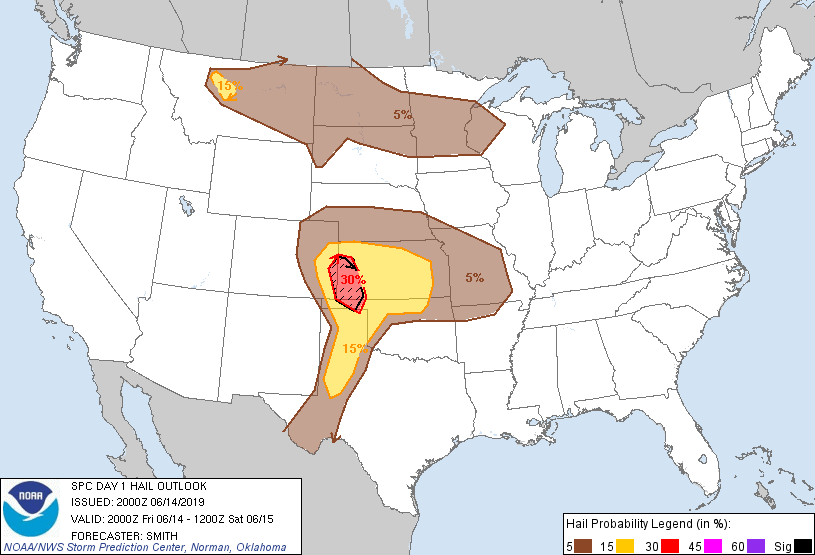
Probabilistic Large Hail Graphic
Probability of hail 1" or larger within 25 miles of a point. Hatched Area: 10% or greater probability of hail 2" or larger within 25 miles of a point.
Day 1 Hail Risk
Area (sq. mi.)
Area Pop.
Some Larger Population Centers in Risk Area
SIG SEVERE
15,436
119,270
Garden City, KS...Liberal, KS...Guymon, OK...
30 %
17,815
124,268
Garden City, KS...Liberal, KS...
15 %
113,083
2,504,832
Wichita, KS...Lubbock, TX...Amarillo, TX...Midland, TX...Great Falls, MT...
5 %
430,804
15,211,132
Kansas City, MO...Omaha, NE...Tulsa, OK...Minneapolis, MN...St. Paul, MN...
   SPC AC 142000

   Day 1 Convective Outlook
   NWS Storm Prediction Center Norman OK
   0300 PM CDT Fri Jun 14 2019

   Valid 142000Z - 151200Z

   ...THERE IS AN ENHANCED RISK OF SEVERE THUNDERSTORMS LATE THIS
   AFTERNOON AND EVENING ACROSS PARTS OF THE CENTRAL HIGH PLAINS...

   ...THERE IS A SLIGHT RISK OF SEVERE THUNDERSTORMS A SMALL PART OF
   CENTRAL MONTANA...

   ...SUMMARY...
   Severe thunderstorms initially accompanied by a risk for severe hail
   may evolve into an organized cluster of storms accompanied by a risk
   for strong wind gusts across parts of eastern Colorado into western
   Kansas, parts of northwestern Oklahoma and perhaps adjacent portions
   of the Texas Panhandle late this afternoon through this evening.

   ...Discussion...
   The only changes made to the previous outlook include the following:

   1) Upgraded a small area of central MT to 15-percent hail
   probabilities based on an ongoing storm moving southeast near the
   nose of a 60-kt northwesterly 300mb jet streak and temperatures
   cooling aloft this afternoon.
   2) Added a small part of western SD into 5-percent hail
   probabilities.

   ..Smith.. 06/14/2019

   .PREV DISCUSSION... /ISSUED 1123 AM CDT Fri Jun 14 2019/

   ...Synopsis...
   A broad mid-level low centered near James Bay may linger through
   this period and beyond, with a belt of seasonably strong cyclonic
   flow maintaining influence across parts of the Upper Midwest and
   Great Lakes region.  However, a significant short wave trough to its
   southeast is forecast to continue a general eastward acceleration,
   across and east of the northern Atlantic coast through tonight.  In
   its wake, a modest to weak, broadly confluent northwesterly to
   westerly flow appears likely to prevail across much of the nation,
   with a number of embedded perturbations.  This includes mid-level
   troughing now digging into the southern Great Basin and forecast to
   continue slowly southeastward through the remainder of the period.

   In the wake of the receding mid-level cold pool associated with the
   eastern trough, and downstream of the lower amplitude Southwestern
   impulse, very warm elevated mixed-layer air is overspreading the
   southern High Plains, and forecast to continue advecting eastward
   across the remainder of the central and southern Plains, toward the
   lower and middle Mississippi Valley.  Beneath this air mass, into
   areas above a residual seasonably cool/stable boundary layer
   associated with Southeastern surface ridging, models indicate
   considerable strengthening of a southerly return flow later today
   through tonight.  This is expected to occur as the low-level ridging
   shifts across and east of the south Atlantic coast.

   Moistening which has already taken place within this regime across
   the central and southern Plains may contribute to moderate to large
   CAPE by late this afternoon, in the presence of steep lapse rates,
   near and east of lee surface troughing.  It appears that boundary
   layer destabilization may remain more modest farther north, along a
   lingering baroclinic zone across the Great Lakes and Upper Midwest,
   west-northwestward through the northern Plains.

   ...Central Plains into lower Missouri Valley...
   Potential for severe thunderstorms this afternoon through tonight
   seems likely to become largely focused near/north of the plume of
   warm elevated mixed-layer air advecting east of the southern
   Rockies.  Mid/upper forcing for ascent downstream of the digging
   southern Great Basin impulse may contribute to the initiation of
   thunderstorm development across the Colorado Rockies by mid
   afternoon.  East/southeastward propagation off the higher terrain
   probably will be aided by a belt of 30-40 westerly mid-level flow
   (across the Colorado Rockies into the central Plains).  As storms
   encounter increasing boundary layer instability (including CAPE of
   2000-3000+ J/kg) near the Colorado/Kansas border, a more rapid
   intensification may ensue by around 22-23Z.

   Initially weak to modest, but veering profiles with height, beneath
   the belt of enhanced mid-level flow is expected to provide
   sufficient shear for supercells.  Given the relatively low
   humidities evident in forecast soundings across the region, severe
   hail and locally strong surface gusts appear the primary hazards
   initially.  Thermodynamic profiles appear supportive of the
   evolution of a fairly strong cold pool as activity gradually grows
   upscale.  And there appears a substantive signal for this in latest
   model output, particularly the NAM and Rapid Refresh/HRRR, which
   indicate potential for the evolution of an organized convective
   system accompanied by a more general risk for severe wind gusts,
   along the gust front of the strengthening cold pool.

   The convective system may progress eastward through much of western
   into central Kansas, and perhaps adjacent portions of northwest
   Oklahoma and the Texas Panhandle, before waning in the presence of
   increasing inhibition for boundary layer parcels by late evening.
   New storm development is then possible farther to the north and
   east, on the edge of the strong mid-level capping, aided by
   strengthening southwesterly 850 mb flow, across parts of the lower
   Missouri Valley and Missouri Ozarks region.  Potential for another
   upscale growing cluster of storms remains more unclear, but activity
   may be accompanied by at least some risk for severe hail and wind.

   ...Texas South Plains...
   Convective potential for late this afternoon and evening is more
   unclear due to the likely eastward advection of increasingly warm
   and capping elevated mixed-layer air.  However, the environment
   likely will be at least conditionally supportive of severe storm
   development, and the initiation of isolated to widely scattered
   storms near the dryline late this afternoon may not be completely
   out of the question.

   ...Northern Plains into parts of upper Mississippi Valley...
   Widely scattered strong thunderstorm development still appears
   possible mainly near and just south of the lingering frontal zone.
   Due to at least some combination of seasonably modest
   destabilization and/or weak to modest wind fields and shear, the
   environment, in general, still appears likely to become only
   marginally supportive of severe weather potential.

   CLICK TO GET WUUS01 PTSDY1 PRODUCT

   NOTE: THE NEXT DAY 1 OUTLOOK IS SCHEDULED BY 0100Z