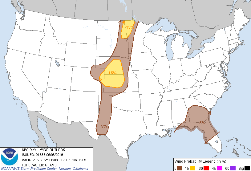
Probability of damaging thunderstorm winds or wind gusts of 50 knots or higher within 25 miles of a point. Hatched Area: 10% of greater probability of wind gusts 65 knots or greater within 25 miles of a point.
Day 1 Wind Risk
Area (sq. mi.)
Area Pop.
Some Larger Population Centers in Risk Area
15 %
90,675
1,041,400
Fargo, ND...Grand Forks, ND...Grand Island, NE...Moorhead, MN...Kearney, NE...
Lubbock, TX...Amarillo, TX...Sioux Falls, SD...Midland, TX...Odessa, TX...
SPC AC 082153
Day 1 Convective Outlook AMEND 1
NWS Storm Prediction Center Norman OK
0453 PM CDT Sat Jun 08 2019
Valid 082150Z - 091200Z
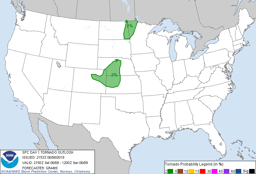
...THERE IS A SLIGHT RISK OF SEVERE THUNDERSTORMS ACROSS MUCH OF
CENTRAL NEBRASKA INTO WESTERN/CENTRAL KANSAS AND NORTHEAST
COLORADO...
AMENDED FOR EXPANSION OF SLIGHT RISK ACROSS NORTHEAST COLORADO
...SUMMARY...
The greatest potential for severe storms will be over parts of the
central Great Plains and Red River of the North area, with large
hail and severe gusts expected.
Please reference MCD 1028 for discussion regarding increased severe
threat across northeast Colorado.
.PREV DISCUSSION... /ISSUED 233 PM CDT Sat Jun 08 2019/
No appreciable change was made to the previous outlook.
Primary severe threat continues to be over Nebraska and western
Kansas where both large hail and damaging winds are possible this
afternoon and evening.
For more information see mesoscale discussion 1026.
..Grams.. 06/08/2019
.PREV DISCUSSION... /ISSUED 1129 AM CDT Sat Jun 08 2019/
...Eastern ND/northwestern MN this afternoon...
A pronounced northern stream shortwave trough will continue to
progress eastward from the northern Rockies to the northern Plains
through Sunday morning. An associated surface cold front will
likewise move eastward across the Dakotas into MN. A narrow moist
corridor east of the cold front extends northward from the central
Plains to the northern Plains, where boundary-layer dewpoints are in
the 60-65 F range this morning. Surface heating in cloud breaks,
low-level ascent along the front, and a remnant MCV moving
north-northeastward across eastern SD will help focus thunderstorm
development in a broken band along the front this afternoon. Given
messy observed wind profiles/hodographs and that the stronger flow
aloft tends to lag the surface cold front, a mix of multicell
clusters and marginal supercells will support threats for damaging
winds and large hail this afternoon.
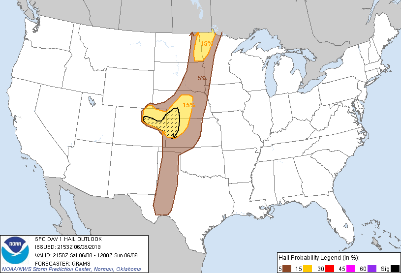
...Central High Plains this afternoon into tonight...
Lee cyclogenesis is expected today across eastern CO at the
intersection of the cold front and lee trough, with faster
southeastward motion of the front expected overnight. This area
will be along the southern fringe of the stronger mid-upper flow
with the northern Rockies trough. Deep-layer vertical shear will be
sufficient for a couple of supercells near the triple point and a
little northward along the front, with very large hail the main
threat with the more discrete storms this afternoon/evening.
Overnight, the potential exists for storms to grow upscale into an
MCS in the vicinity of northwest KS, where the surging cold front
intersects a developing nocturnal low-level jet and the corridor of
strongest buoyancy. The convection should subsequently move
southeastward toward central KS by the end of the period. Lingering
steep midlevel lapse rates and strong downdraft potential suggest
the possibility of a corridor of damaging winds with this overnight
convection. However, uncertainty is high enough regarding MCS
track/intensity and efficiency of the storms to produce damaging
winds to hold off on introducing greater (30%) wind probabilities in
this update.
...Southern High Plains this afternoon/evening...
Forcing for ascent will generally remain weak along a sharpening
dryline this afternoon from southwest KS southward near the TX/NM
border into southwest TX. As temperatures warm into the 90s,
convective inhibition will weaken in a narrow zone along the
dryline, such that isolated storm development will be possible. The
deeply mixed environment with steep lapse rates and effective bulk
shear of 30-35 kt will favor high-based supercells capable of
producing isolated large hail and damaging gusts, prior to the
storms weakening late evening.
...North FL/GA area this afternoon...
A midlevel low over the TN Valley will move little as weak embedded
speed maxima rotate around the southern and eastern periphery of the
low. Convection this morning is widespread along and off the
northeast Gulf coast, and prior convection has left a residual cold
pool across north FL. There will be a window of opportunity for a
few strong storms this afternoon in the zone of cloud breaks across
west central and central GA, where moderate buoyancy and 25-30 kt
south-southwesterly low-midlevel flow may support storms capable of
producing isolated strong outflow gusts. The widespread convection
casts doubt on the degree of recovery across the FL Panhandle into
north FL and south GA.
CLICK TO GET WUUS01 PTSDY1 PRODUCT
NOTE: THE NEXT DAY 1 OUTLOOK IS SCHEDULED BY 0100Z