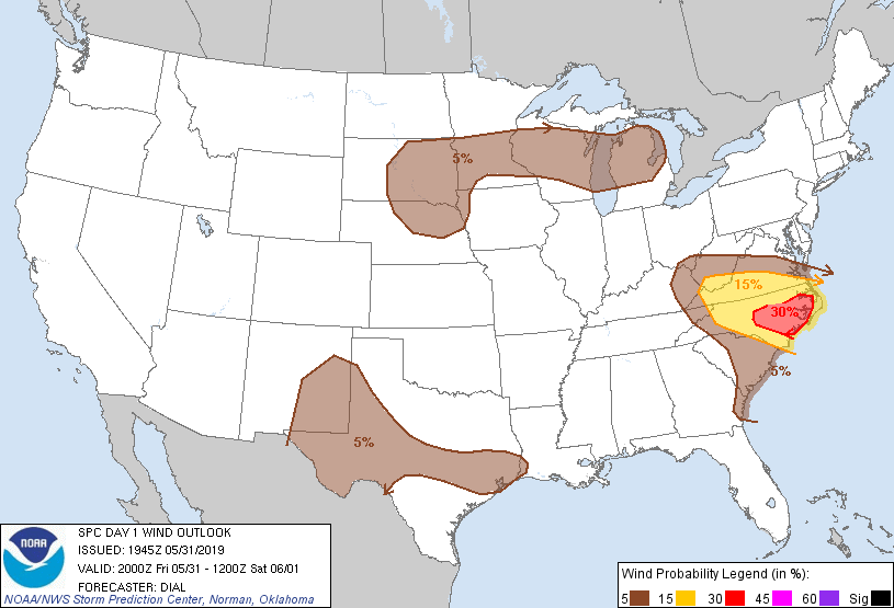
Probability of damaging thunderstorm winds or wind gusts of 50 knots or higher within 25 miles of a point. Hatched Area: 10% of greater probability of wind gusts 65 knots or greater within 25 miles of a point.
Houston, TX...Austin, TX...Virginia Beach, VA...Minneapolis, MN...St. Paul, MN...
SPC AC 311945
Day 1 Convective Outlook
NWS Storm Prediction Center Norman OK
0245 PM CDT Fri May 31 2019
Valid 312000Z - 011200Z
...THERE IS AN ENHANCED RISK OF SEVERE THUNDERSTORMS OVER EASTERN
NORTH CAROLINA...
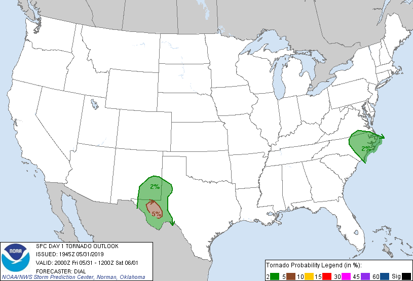
...THERE IS A SLIGHT RISK OF SEVERE THUNDERSTORMS OVER SOUTHWEST
TEXAS INTO EASTERN NEW MEXICO...
...SUMMARY...
Severe storms will persist across North Carolina and southern
Virginia producing damaging winds and hail into the evening. Severe
storms are also expected across Far West Texas and southeast New
Mexico late this afternoon into the evening.
...Discussion...
Previous forecast remains generally on track with only minor
adjustments needed. Severe storms ongoing across NC into VA will
persist into the evening. Other severe storms including a few
supercells should develop this afternoon across west TX. See SWOMCD
911 for more details. Strong storms with more sparse coverage are
also expected from a portion of the northern and central Plains into
the Great Lakes region.
..Dial.. 05/31/2019
.PREV DISCUSSION... /ISSUED 1127 AM CDT Fri May 31 2019/
...South-central Appalachians to Carolinas/southern Virginia...
A shortwave trough over KY/TN will track east into southern VA and
NC tonight. A cyclonically curved belt of moderately strong
westerlies (35-50 kt at 500 mb) will persist downstream across the
Carolinas and southern Appalachians. Boundary-layer heating is
underway ahead of the trough, beneath 6.5 to 7 C/km mid-level lapse
rates. The most robust buoyancy/strongest instability should develop
across the eastern NC vicinity by peak heating where surface
temperatures warming into the low to mid 90s overlap mid 60s dew
points.
A cluster of convection is ongoing near the OH/KY/WV border area and
thunderstorms will become increasingly numerous downstream to the
southeast across the Appalachians. Additional scattered
thunderstorms should evolve east across the Piedmont and along the
sea breeze, most probable across NC. While low-level winds should
remain modest, speed shear between the low to upper-levels should
foster several cells with mid-level rotation with an attendant
severe hail and damaging wind threat. The greatest likelihood for
clustering appears to be across central to eastern NC where the
environment would support an enhanced risk for strong to isolated
severe wind gusts.
..Texas to eastern NM...
An isolated damaging wind and marginally severe hail risk should
exist downstream of an ongoing short line segment in east-central
TX. 2000-2500 J/kg of MLCAPE will be common ahead of this segment,
with potential for additional development towards the Upper TX
Coastal Plain this afternoon. Modest deep-layer shear should limit
the potential for greater organization.
Farther west, weak mid/upper height rises will occur late today into
tonight. Nevertheless, ample low-level moisture characterized by low
to mid 60s surface dew points currently across the Pecos
Valley/Permian Basin will foster scattered storm development over
the higher terrain of southeast NM and the TX Trans-Pecos by late
afternoon. A veering wind profile with height in conjunction with
favorable speed shear from 500-250 mb should support a large hail
risk along with isolated sig. Consolidation of convection into a
small MCS tonight appears possible in parts of west TX. Increasingly
weak 700-500 mb flow amid the height rises should limit organization
potential and marginalize the risk for severe wind gusts.
...Upper Midwest/Upper Great Lakes...
Guidance appears to be overly aggressive (especially the NAM) with
the degree of evapotranspiration ahead of the southward-moving cold
front. 12Z observed soundings from Green Bay, Minneapolis,
International Falls, and Aberdeen sampled mean-mixing ratios only
around 7 g/kg. Given the predominant westerly low-level flow ahead
of front, model forecasts up to 13 g/kg by early evening appear
woefully too high.
Cloud-free diabatic heating will yield very warm surface
temperatures coincident with very steep mid-level lapse rates.
Boundary-layer dew points should mix into the lower to mid 50s and
yield a plume of modest buoyancy at peak heating. Scattered
thunderstorm development is most likely across SD into far northern
NE in association with a minor mid-level impulse shifting east from
the Black Hills. More isolated thunderstorm coverage is anticipated
immediately along the front from central MN into northern Lower MI.
The eastern portion of the front should overlap the periphery of
moderate mid-level westerlies and could support a few cells with
mid-level updraft rotation capable of isolated severe wind and hail
during the late afternoon and evening.
CLICK TO GET WUUS01 PTSDY1 PRODUCT
NOTE: THE NEXT DAY 1 OUTLOOK IS SCHEDULED BY 0100Z