The SPC is forecasting ...Severe thunderstorms expected over parts of the central Plains from midday into the overnight....
Please read
the latest public statement about this event. View What is a Watch? clip.
Categorical Graphic
Day 1 Risk
Area (sq. mi.)
Area Pop.
Some Larger Population Centers in Risk Area
MODERATE
35,761
3,077,855
Kansas City, MO...Overland Park, KS...Kansas City, KS...Topeka, KS...Olathe, KS...
ENHANCED
123,562
22,248,644
Philadelphia, PA...Oklahoma City, OK...Tulsa, OK...Wichita, KS...Pittsburgh, PA...
SLIGHT
212,856
35,670,695
New York, NY...Baltimore, MD...Cleveland, OH...Omaha, NE...St. Louis, MO...
Probability of a tornado within 25 miles of a point. Hatched Area: 10% or greater probability of EF2 - EF5 tornadoes within 25 miles of a point.
Day 1 Tornado Risk
Area (sq. mi.)
Area Pop.
Some Larger Population Centers in Risk Area
SIG SEVERE
25,714
2,829,769
Kansas City, MO...Overland Park, KS...Kansas City, KS...Topeka, KS...Olathe, KS...
10 %
32,367
2,977,683
Kansas City, MO...Overland Park, KS...Kansas City, KS...Topeka, KS...Olathe, KS...
5 %
151,071
28,549,896
Philadelphia, PA...Oklahoma City, OK...Tulsa, OK...Wichita, KS...Pittsburgh, PA...
2 %
193,964
29,198,357
New York, NY...Fort Worth, TX...Baltimore, MD...Cleveland, OH...St. Louis, MO...
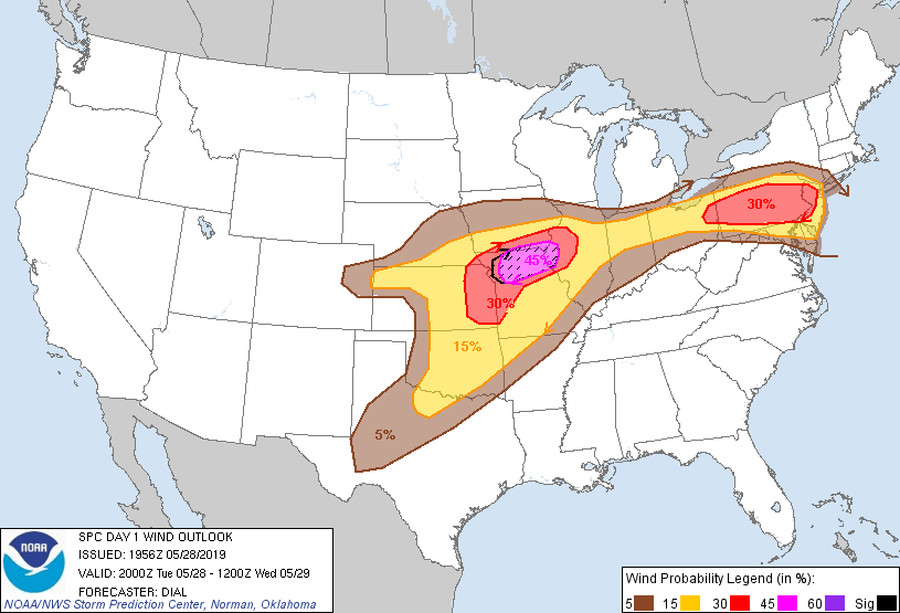
Probabilistic Damaging Wind Graphic
Probability of damaging thunderstorm winds or wind gusts of 50 knots or higher within 25 miles of a point. Hatched Area: 10% of greater probability of wind gusts 65 knots or greater within 25 miles of a point.
SPC AC 281956
Day 1 Convective Outlook
NWS Storm Prediction Center Norman OK
0256 PM CDT Tue May 28 2019
Valid 282000Z - 291200Z
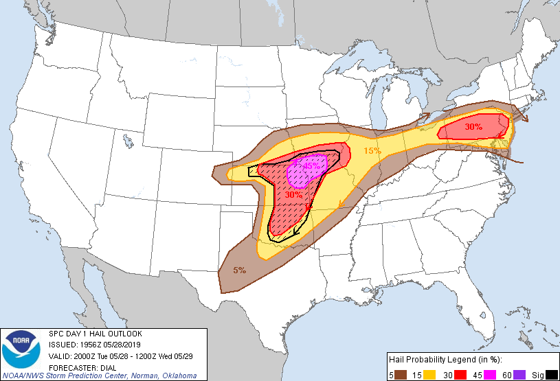
...THERE IS A MODERATE RISK OF SEVERE THUNDERSTORMS FROM NORTHEAST
KANSAS INTO NORTHERN MISSOURI AND EXTREME SOUTHERN IOWA...
...THERE IS AN ENHANCED RISK OF SEVERE THUNDERSTORMS FROM EASTERN
OHIO INTO PENNSYLVANIA AND NEW JERSEY...
...SUMMARY...
Severe storms, capable of producing large hail, damaging wind and
tornadoes are likely this afternoon into tonight from the central
and a portion of the southern Plains eastward to the Midwest. Severe
storms with a threat for large hail, damaging wind and a couple of
tornadoes will also persist across the Upper Ohio Valley and
Northeast States through the evening.
...Discussion...
Overall previous forecast appears on track. Primary change has been
to expand moderate risk category farther southwest into northeast
KS. Storms are expected to develop over south central KS along and
ahead of Pacific front this afternoon and spread northeast through
the strongly unstable warm sector. Vertical wind profiles with 40-50
kt effective bulk shear will support supercells capable of very
large hail. Low-level mesocyclone and tornado threat will also
increase, especially toward evening, as the low-level jet
strengthens and augments 0-1 km hodograph size. Elsewhere, the
special 17Z RAOB from Norman OK indicates the inversion layer has
cooled (possibly due to ascent) compared to 12Z. It still appears
probable that discrete supercells will develop across west central
OK and possibly as far south as northwest and north central TX this
afternoon into the evening.
..Dial.. 05/28/2019
.PREV DISCUSSION... /ISSUED 1127 AM CDT Tue May 28 2019/
...Plains/Mid MS Valley region through tonight...
A closed midlevel low over CO this morning will move slowly
east-northeastward toward NE overnight. At the surface, a cyclone
in north central KS is expected to move east-northeastward toward
extreme northwest MO, as a trailing cold front moves slowly
southeastward across western/central KS into northwest OK and the TX
Panhandle. South of the cyclone this afternoon, a dryline will
sharpen across western OK and northwest TX. East of the low, a
sharp east-west front (reinforced by convective outflow this
morning) will persist across northeast KS and northern MO. These
surface boundaries will provide the primary foci for severe
thunderstorm development later today into tonight.
A loose cluster of elevated thunderstorms across central KS could
persist into the afternoon as the low levels destabilize and the
convection begins to interact with the baroclinic zone in northeast
KS. Convection will likely become rooted at the surface this
afternoon, within an environment favorable for supercells.
Tornadoes will be possible with any semi-discrete supercells, and
with more complex storm-boundary interactions. It appears likely
that convection will grow upscale by late afternoon into an MCS that
will traverse northern MO/southern IA into tonight, with an
accompanying threat for large hail and swaths of damaging winds.
Farther south along the dryline, widely scattered to scattered
thunderstorm development is expected from 21-00z as convective
inhibition weakens. Strong buoyancy (MLCAPE greater than 3000 J/kg)
and long hodographs will support supercells capable of producing
very large hail and damaging winds. Low-level shear/hodograph
curvature will not be particularly favorable tornadic supercells
during the afternoon. However, a couple of tornadoes will still be
possible, especially with any storms/clusters than can persist
beyond sunset when some increase in low-level shear is expected.
...Mid-Atlantic to the OH Valley this afternoon/evening...
A weak surface cyclone in extreme southeast Lower MI will translate
eastward near the NY/PA border this afternoon in association with
subtle speed maxima in the westerlies aloft, as a surface warm front
moves east-northeastward into eastern PA/NJ. The warm sector will
become moderately unstable by early afternoon (MLCAPE near 2000
J/kg) with minimal convective inhibition, and scattered thunderstorm
development is expected near the path of the surface low and along
the trailing east-west oriented front near 18z. Moderate buoyancy
and effective bulk shear of 50 kt or greater with long, relatively
straight hodographs will support splitting supercells in the warm
sector. These storms will be capable of producing large hail and
damaging winds into this evening. Additionally, a few tornadoes
will be possible, given sufficient low-level shear/hodograph
curvature (0-1 km SRH in excess of 150 m2/s2) from PA into NJ,
especially near the surface warm front.
Scattered thunderstorm development is also expected this afternoon
from northern IN into northern OH along the east-west front, as the
low levels destabilize and in advance of a remnant MCV emanating
from the ongoing IA convection. Effective bulk shear of 35-40 kt
and straight hodographs will support a mix of supercells and
multicell clusters capable of producing large hail and damaging
gusts.
CLICK TO GET WUUS01 PTSDY1 PRODUCT
NOTE: THE NEXT DAY 1 OUTLOOK IS SCHEDULED BY 0100Z