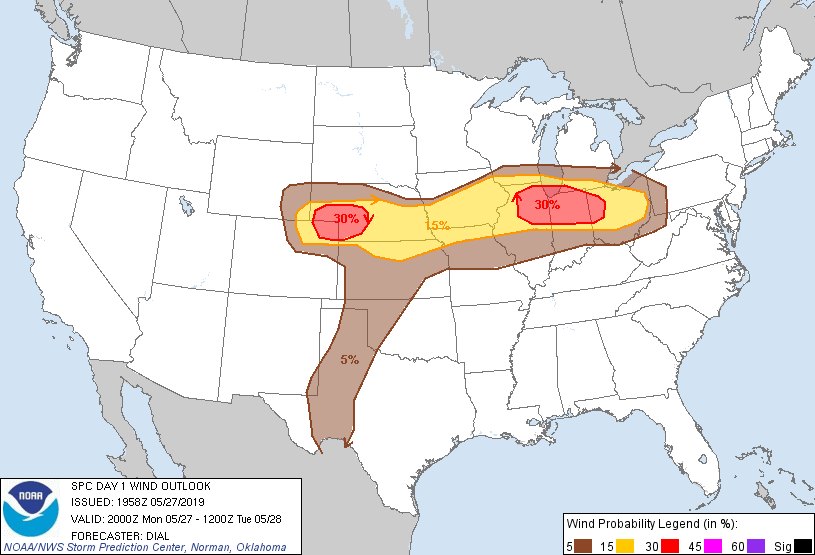
Probability of damaging thunderstorm winds or wind gusts of 50 knots or higher within 25 miles of a point. Hatched Area: 10% of greater probability of wind gusts 65 knots or greater within 25 miles of a point.
Detroit, MI...Milwaukee, WI...Denver, CO...Kansas City, MO...Cleveland, OH...
   SPC AC 271958

   Day 1 Convective Outlook
   NWS Storm Prediction Center Norman OK
   0258 PM CDT Mon May 27 2019

   Valid 272000Z - 281200Z

   ...THERE IS AN ENHANCED RISK OF SEVERE THUNDERSTORMS OVER A PORTION
   OF THE CENTRAL HIGH PLAINS AND THE UPPER MIDWEST INTO A PORTION OF
   THE OHIO VALLEY...

   ...SUMMARY...
   Severe thunderstorms, including a risk for tornadoes, severe hail
   and damaging wind gusts, are expected to persist across the Midwest
   this afternoon into tonight including eastern Iowa to northern
   portions of Illinois/Indiana. Severe threat should spread eastward
   through the Ohio Valley this evening. Severe storms are also
   expected across the central High Plains, and perhaps southward
   through the Texas South Plains on a more isolated basis.

   ...Discussion...

   Have expanded 5% tornado probabilities farther east into OH (per
   coordination with WFO ILM) to account for the possibility of a
   supercell or two capable of producing tornadoes along
   northward-advancing warm front. Low-level hodographs will become
   supportive of low-level mesocyclones as the low-level jet increases
   in this region toward evening. Have also expanded slight risk area
   for wind farther east into OH in association with expected MCS
   development that should continue east southeast tonight along and
   north of warm front.

   Elsewhere have expanded the marginal risk area farther northwest
   into southeast MN where low-topped supercells may continue to pose a
   risk for a couple of brief tornadoes as they move northeast and
   interact with warm front next hour or two.

   ..Dial.. 05/27/2019

   .PREV DISCUSSION... /ISSUED 1122 AM CDT Mon May 27 2019/

   ...Northern IL/IN this afternoon into early tonight...
   A convectively-enhanced midlevel trough over northwestern IA will
   crest the midlevel ridge over the MS Valley and begin to move more
   eastward this afternoon into this evening.  Enhanced low-midlevel
   southwesterly flow (up to 60 kt per regional VWPs) on the
   southeastern flank of the trough/MCV will overspread the surface
   warm front and destabilizing warm sector from eastern IA across
   northern IL this afternoon.  Per 12z soundings, midlevel lapse rates
   are not steep as a result of widespread prior convection across the
   central Plains, but the cap is also not strong.  Daytime heating in
   the wake of ongoing convection in northwestern IL, and northward
   advection of richer low-level moisture from southern/central IL,
   will contribute to moderate buoyancy (MLCAPE of 1500-2000 J/kg) by
   mid afternoon, when surface-based thunderstorm development is
   likely.

   Both effective bulk shear and 0-1 km SRH will be well into the
   supercell/tornado parameter space (greater than 50 kt and 200 m2/s2,
   respectively) in the moist low-level environment.  Thus, a few
   supercells appear likely, with the potential to produce isolated
   strong tornadoes.  The storms will spread eastward from IL into
   northern IN through this evening, with a continued tornado threat
   into early tonight.  Damaging winds will become more probable this
   evening if any upscale growth into clusters occur, while the
   supercells will also be capable of producing large hail.

   ...Central High Plains this afternoon into tonight...
   A deep midlevel low over the southern Great Basin will pivot
   northeastward toward CO tonight, as associated lee cyclogenesis
   occurs across eastern CO.  Low-level moisture has been reduced
   across the central Plains in the wake of widespread overnight
   convection, with boundary-layer dewpoints generally limited to the
   low-mid 50s.  However, daytime heating beneath steep midlevel lapse
   rates will contribute to moderate buoyancy (MLCAPE of 1000-1500
   J/kg) this afternoon across far southwestern NE, southeastern WY and
   northeastern into north central CO.

   Strengthening low-level upslope flow and background ascent within
   the left-exit region of the mid-upper jet will promote thunderstorm
   development by mid afternoon near the front range from Denver to
   Laramie, as well as near the triple point in northeastern CO.
   Storms will subsequently spread eastward through the evening into
   early tonight along and immediately north of an east-west front.
   Wind profiles will favor supercells with very large hail, as well as
   a couple of tornadoes, with damaging winds and some upscale growth
   into a cluster possible tonight across NE.

   ...Eastern TX Panhandle and vicinity this evening...
   The dryline will sharpen this afternoon across the TX Panhandle, and
   will likely retreat some to the west this evening.  Though forcing
   for ascent will not be strong, weak midlevel height falls are
   expected, and low-midlevel flow will have enough southerly component
   to allow reasonably long residence time for parcels within the
   dryline circulation.  Thus, will extend the SLGT risk southward to
   account for isolated storm development this evening (and perhaps
   some convection overnight), and the conditional threat for
   supercells with large hail and perhaps a tornado.

   CLICK TO GET WUUS01 PTSDY1 PRODUCT

   NOTE: THE NEXT DAY 1 OUTLOOK IS SCHEDULED BY 0100Z