The SPC is forecasting ...Severe thunderstorms expected over parts of the central High Plains this afternoon and tonight....
Please read
the latest public statement about this event. View What is a Watch? clip.
Categorical Graphic
Day 1 Risk
Area (sq. mi.)
Area Pop.
Some Larger Population Centers in Risk Area
MODERATE
43,654
530,929
Amarillo, TX...Garden City, KS...Liberal, KS...Hereford, TX...Dumas, TX...
ENHANCED
70,898
676,569
Salina, KS...Clovis, NM...Kearney, NE...Dodge City, KS...Hastings, NE...
Probability of damaging thunderstorm winds or wind gusts of 50 knots or higher within 25 miles of a point. Hatched Area: 10% of greater probability of wind gusts 65 knots or greater within 25 miles of a point.
Day 1 Wind Risk
Area (sq. mi.)
Area Pop.
Some Larger Population Centers in Risk Area
45 %
20,118
140,766
Garden City, KS...Hays, KS...
30 %
73,351
945,519
Amarillo, TX...Salina, KS...Kearney, NE...Dodge City, KS...Hastings, NE...
Indianapolis, IN...Omaha, NE...Colorado Springs, CO...Wichita, KS...Pittsburgh, PA...
SPC AC 261627
Day 1 Convective Outlook
NWS Storm Prediction Center Norman OK
1127 AM CDT Sun May 26 2019
Valid 261630Z - 271200Z
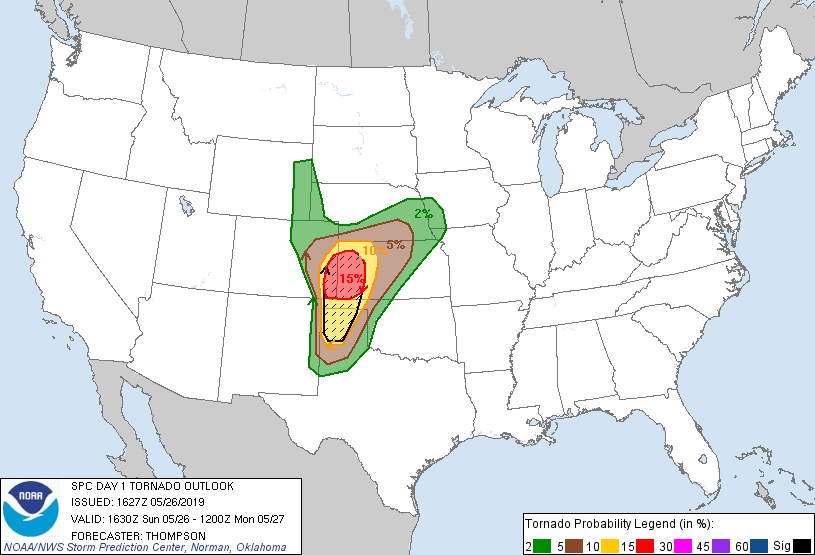
...THERE IS A MODERATE RISK OF SEVERE THUNDERSTORMS THIS AFTERNOON
INTO EARLY TONIGHT FOR PARTS OF THE CENTRAL/SOUTHERN HIGH PLAINS...
...THERE IS A SLIGHT RISK OF SEVERE THUNDERSTORMS THIS AFTERNOON
INTO EARLY TONIGHT FROM THE OHIO VALLEY TO THE MID-ATLANTIC...
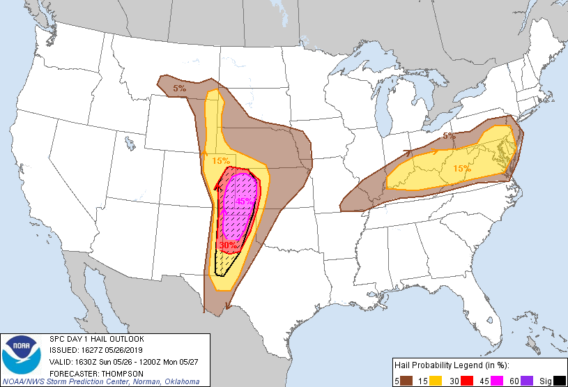
...SUMMARY...
Severe thunderstorms are likely today into tonight across much of
the central Plains and southern High Plains, with all aspects of
severe weather expected. Additional severe thunderstorms are
possible across the Ohio Valley to the Mid-Atlantic, accompanied by
a risk for severe wind and hail.
...High Plains this afternoon into tonight...
Downstream from a deep closed low digging south-southeastward along
the CA coast, a lead shortwave trough over southern AZ will eject
northeastward to the central High Plains by late evening. In
response, lee cyclogenesis will occur across CO, as a diffuse warm
front (reinforced by overnight convection) moves northward across
western KS. Richer low-level moisture will be drawn northward from
the TX Panhandle into western KS/eastern CO, beneath an elevated
mixed layer plume. Strong buoyancy (MLCAPE at or above 3000 J/kg)
is expected this afternoon south of the warm front and east of a
developing dryline across the High Plains.
Surface heating/mixing, as well as ascent preceding the ejecting
midlevel trough, will support thunderstorm development along the
dryline by mid afternoon from extreme northeast NM into eastern CO
along the dryline. An increase in low-level shear later this
afternoon/evening, within the unstable/moist environment, will be
supportive of supercells capable of producing tornadoes (a few of
which could be strong) and very large hail. The storm evolution by
late afternoon/evening could become more complex with storm
interactions and upscale growth possible, especially near the warm
front along the KS/CO border, though eventual consolidation of
storms may also occur farther south along the dryline near and after
sunset. The convection is expected to persist overnight across
KS/NE, with the threat for damaging gusts and a few tornadoes with
embedded circulations, and storms could reach western IA near the
end of the period with at least a marginal wind threat.
...OH Valley to Mid-Atlantic through early tonight...
A somewhat diffuse MCV and remnant convection are moving over
western PA as of midday will continue eastward/east-southeastward
over southern PA/northern VA/MD this afternoon. Destabilization in
advance of this subtle wave will support at least isolated storm
development this afternoon, in an environment with straight
hodographs (effective bulk shear 35-40 kt) and moderate buoyancy
(MLCAPE near 1500 J/kg). Damaging gusts and large hail will be the
main threats.
Farther west, a more pronounced shortwave trough near Saint Louis as
of mid morning will progress eastward over the OH Valley through the
afternoon and evening. Moderate buoyancy will be present this
afternoon in advance of the shortwave trough, along the synoptic
front from southern IL across southern IN into OH, as well as a
weakening outflow boundary from northern WV into northern KY.
Additional storm development is expected along these boundaries and
in advance of the midlevel trough, with damaging gusts/large hail
expected with storm clusters/embedded supercells. The storm
clusters could persist into late evening/early tonight while moving
east of the Appalachians.
..Thompson/Nauslar.. 05/26/2019
CLICK TO GET WUUS01 PTSDY1 PRODUCT
NOTE: THE NEXT DAY 1 OUTLOOK IS SCHEDULED BY 2000Z