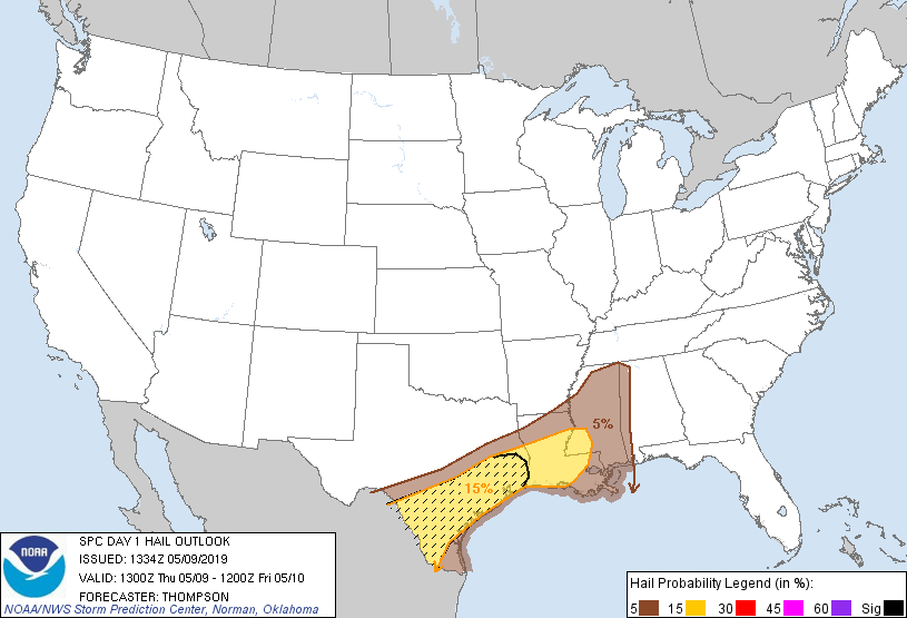
Probability of damaging thunderstorm winds or wind gusts of 50 knots or higher within 25 miles of a point. Hatched Area: 10% of greater probability of wind gusts 65 knots or greater within 25 miles of a point.
SPC AC 091334
Day 1 Convective Outlook RESENT 1
NWS Storm Prediction Center Norman OK
0834 AM CDT Thu May 09 2019
Valid 091300Z - 101200Z
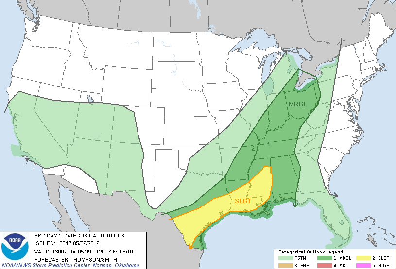
...THERE IS A SLIGHT RISK OF SEVERE THUNDERSTORMS THROUGH THIS
EVENING FROM MS TO SOUTH TX...
...SUMMARY...
Scattered severe thunderstorms are expected from Mississippi and
Louisiana to south Texas through this evening. Damaging winds and
large hail will be the main threats.
...MS to south TX through this evening...
Overnight warm advection thunderstorms across LA/MS have gradually
merged into more of a QLCS which will move east-southeastward
through the day across LA/MS/AL. Tropical moisture is present to
the south of the QLCS from TX to MS, and the steeper midlevel lapse
rates are confined to areas farther west across TX. MLCAPE today
will range from 2000 J/kg across southern MS to greater than 4000
J/kg across south TX. Low-level flow/shear is favorable for
right-moving supercells this morning across LA/MS in the warm
advection zone. However, low-level flow will weaken through midday
(as confirmed by the VWP at POE since 09z) as an associated
mid-upper speed max translates northeastward from AR toward the OH
Valley. Low-level flow will remain weak to the west in TX, but
effective bulk shear will be sufficient for supercells (as well as
splitting storms across south TX).
The convective mode will remain predominantly linear across MS
today, with a gradual transition to anafrontal convection across LA
atop the reinforced cold pool. The eastern extent of the severe
threat will be limited by more marginal buoyancy farther to the east
across AL. Farther west, weakening convective inhibition in the
warm sector and a cold front moving slowly southward will help focus
thunderstorm development this afternoon in TX, and storms may also
form over the higher terrain in Mexico and cross the Rio Grande.
Given the potential for some supercell structures in an environment
with strong buoyancy and steep midlevel lapse rates, isolated very
large hail will be possible in TX. Otherwise, damaging gusts and
perhaps a brief tornado or two can be expected through this evening.
...TN to the OH Valley today...
From TN into the OH Valley, buoyancy will be limited (MLCAPE
500-1000 J/kg) by clouds slowing surface heating, mediocre midlevel
lapse rates, and rather modest low-level moisture north of the
widespread convection across LA/MS. Likewise, vertical shear will
not be particularly strong within the warm sector. Isolated
strong/damaging gusts will be the main concern.
..Thompson/Smith.. 05/09/2019
CLICK TO GET WUUS01 PTSDY1 PRODUCT
NOTE: THE NEXT DAY 1 OUTLOOK IS SCHEDULED BY 1630Z