New York, NY...Philadelphia, PA...Detroit, MI...Indianapolis, IN...Baltimore, MD...
SPC AC 200548
Day 2 Convective Outlook
NWS Storm Prediction Center Norman OK
1248 AM CDT Thu Sep 20 2018
Valid 211200Z - 221200Z
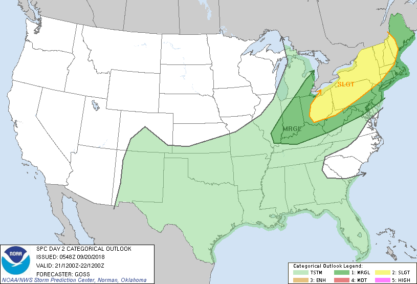
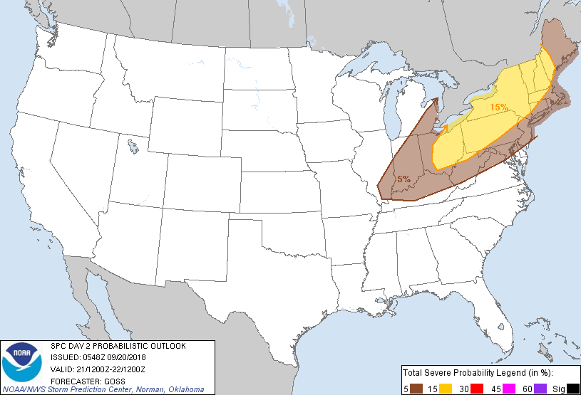
...THERE IS A SLIGHT RISK OF SEVERE THUNDERSTORMS FROM CENTRAL AND
EASTERN OHIO EAST/NORTHEAST INTO NEW ENGLAND...
...SUMMARY...
Potential for severe storms -- posing primarily a damaging-wind risk
-- is expected across the Northeast and Ohio Valley Friday.
...Synopsis...
Mid- and upper-level troughing, initially moving across the Upper
Great Lakes region, is forecast to advance quickly
east-northeastward, crossing southern Ontario and the lower Great
Lakes region, before eventually reaching the Canadian Maritimes and
New England. In the wake of this trough, westerly/zonal flow will
prevail across the northern U.S., in advance of the
next/low-amplitude eastern Pacific trough -- expected to reach the
Pacific Northwest late. Farther south, weak troughing will drift
across parts of the central and southern Plains, while a ridge
persists over the Southeast.
At the surface, the main feature of interest will be a
strong/rapidly advancing cold front, trailing southwestward from a
deepening low progged to lie near eastern Lake Superior at the start
of the period. As this low moves quickly northeastward across
Quebec through the period, the trailing front will cross the Great
Lakes region and later New England, while settling more slowly
southeastward across the Midwest/Ohio Valley with time. By the end
of the period, the boundary should extend from near the New England
coast southwestward to the Mid-Atlantic region, and then
west-southwest across the Tennessee River Valley and Mississippi
Delta region to the Red River Valley.
...Parts of the Ohio Valley area eastward across the Northeast...
A band of showers and thunderstorms is forecast to redevelop along
the advancing cold front by midday/early afternoon, as diurnal
heating allows some destabilization to occur -- particularly from
the Midwest to PA/NY. Farther northeast, much weaker instability is
expected into New England. Still, as the line of storms advances,
strong flow aloft through a deep layer should allow
organization/upscale growth into a semi-solid squall line, which
should be crossing the Ohio Valley and lower Great Lakes region
through sunset. While marginal hail will be possible with a few of
the stronger updrafts, mainly from western New York southwestward,
damaging winds will likely be the primary severe risk. The wind
potential should continue into the evening as the storms spread east
of the Lower Great Lakes, but with diurnal cooling underway, the
already meager instability expected along and east of the
Appalachians should eventually result in a gradual decrease in wind
risk. Still, given strength of flow aloft, gusty/locally damaging
winds may persist through much of the period as the front approaches
the New England coast -- even after lightning has diminished within
the frontal convective band.
...MAXIMUM RISK BY HAZARD...
Tornado: 5% - Slight
Wind: 15% - Slight
Hail: 15% - Slight
..Goss.. 09/20/2018
CLICK TO GET WUUS02 PTSDY2 PRODUCT
NOTE: THE NEXT DAY 2 OUTLOOK IS SCHEDULED BY 1730Z