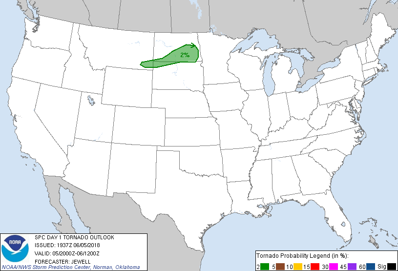
Probability of a tornado within 25 miles of a point. Hatched Area: 10% or greater probability of EF2 - EF5 tornadoes within 25 miles of a point.
Day 1 Tornado Risk
Area (sq. mi.)
Area Pop.
Some Larger Population Centers in Risk Area
2 %
33,496
207,679
Bismarck, ND...Mandan, ND...Jamestown, ND...Valley City, ND...
Probabilistic Damaging Wind Graphic
Probability of damaging thunderstorm winds or wind gusts of 50 knots or higher within 25 miles of a point. Hatched Area: 10% of greater probability of wind gusts 65 knots or greater within 25 miles of a point.
SPC AC 051937
Day 1 Convective Outlook
NWS Storm Prediction Center Norman OK
0237 PM CDT Tue Jun 05 2018
Valid 052000Z - 061200Z
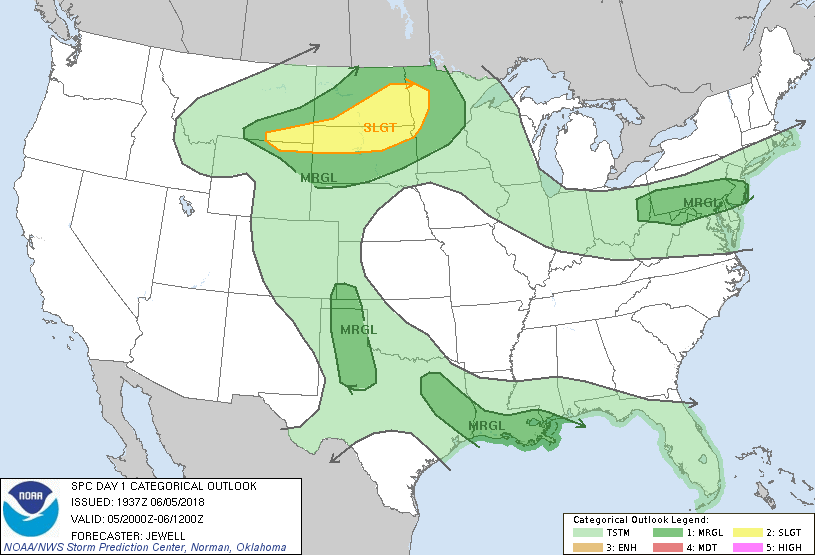
...THERE IS A SLIGHT RISK OF SEVERE THUNDERSTORMS ACROSS PARTS OF
THE NORTHERN PLAINS...
...SUMMARY...
A few severe thunderstorms with large hail and wind damage are
forecast across the northern Plains late this afternoon into
tonight. Isolated strong to severe storms are also possible this
afternoon from east Texas into Louisiana, over the southern High
Plains late this afternoon and evening, and from the upper Ohio
Valley into the Mid-Atlantic region this afternoon.
...Northern Plains Update...
East/northeasterly flow is maintaining 50s F dewpoints into eastern
MT with an expanding CU field toward the Wind River range. Upslope
flow and continued heating may result in a few severe storms, with
areal coverage limited by a minor capping inversion to the east.
However, long hodographs and substantial deep-layer shear will
support storm longevity, perhaps as far as western SD. As such, have
expanded the Slight Risk westward into MT and far northeast WY for a
hail and wind threat.
..Jewell.. 06/05/2018
.PREV DISCUSSION... /ISSUED 1129 AM CDT Tue Jun 05 2018/
...Northern Plains Region...
Water vapor imagery shows a well-defined low amplitude short wave
trough currently approaching the northern Rockies. This feature is
expected to move across the far northern Plains tonight. In
response to this short wave trough, a surface low is expected to
persist over western South Dakota into the evening before moving
toward southeast North Dakota tonight, with a northeast-southwest
oriented cold front progressing eastward and reaching a northwest
Minnesota-south central South Dakota line by the end of the period.
Visible imagery indicates limited clouds over the area with strong
diabatic heating likely to occur into the afternoon. However, 12Z
regional soundings exhibit a strong cap that will inhibit
development of surface-based convection during peak heating over the
Dakotas east of the higher terrain. A modest increase in low-level
moisture is possible this afternoon and evening with surface dew
points in the upper 50s to lower 60s expected, and with steep
mid-level lapse rates in place, will contribute to moderate
instability with MLCAPE of 1500-2000 J/kg.
Storms are more likely to develop initially over the higher terrain
of northern Wyoming/southern Montana and the Black Hills vicinity by
late afternoon and early evening as orographic forcing combines with
weak large scale ascent in advance of the aforementioned short wave
trough. The convection will spread eastward across parts of the
Dakotas and eventually move into parts of northern and central
Minnesota as a nocturnally enhanced southwest low-level jet
strengthens during the evening and shifts eastward with time.
Deep-layer shear associated with 35-45 kt westerly mid level winds
will be sufficient to enhance storm organization with a few
supercells and possible bow echo segments developing. Occasional
large hail and severe wind gusts will be the primary threats as
activity spreads eastward through much of the overnight hours.
...East Texas into southern Louisiana...
Storms clusters continue to develop along the southwest periphery of
a short wave trough that is moving southeastward across the Arklatex
region. The widespread clouds associated with the convection have
generated a differential heating boundary from east central Texas
into central Louisiana, with visible imagery showing cumulus cloud
streets spreading into the boundary across southeast Texas and
southwest Louisiana. 12Z soundings showed moderate-to-strong
mid-level lapse rates over the area, and with surface dew points in
the low-to-mid 70s, the air mass is unstable with MLCAPE of
1500-2000 J/kg. Northwest winds aloft around 30 kt contributing to
sufficient shear to support primarily organized multi-cell clusters
and short line segments this afternoon.
Storms along the leading edge of the current convection will
continue to develop southeastward with potential for stronger cells
to produce strong wind gusts. Current radar imagery shows the
convective outflow moving ahead of the storm cores in west-central
Louisiana, which may limit potential for a more widespread severe
wind threat. In addition, the favorable lapse rates suggest
potential for marginally severe hail. Activity will continue
southeastward through the afternoon before weakening begins by early
evening.
...Southern High Plains...
Strong heating is occurring over this region leading to vertical
profiles with steep low-to-mid level lapse rates this afternoon and
evening. Boundary layer mixing will result in a dry line shifting
eastward this afternoon which will provide a focus for convective
initiation. Veering winds with height immediately in advance of the
upper ridge will support organized multi-cells or an isolated
supercell during the afternoon and evening, but weak large scale
ascent may limit the extent of convective coverage. Large hail and
strong wind gusts will be possible with stronger cells.
...Upper Ohio Valley to Delmarva Region...
A strong short wave trough will progress southeastward this
afternoon from the lower Great Lakes into the Mid-Atlantic region
accompanied by a cold front moving across the area. Despite
marginal moisture and instability, strong dynamic forcing for ascent
and convergence along the front may focus development of low-topped
convection into the evening hours. 12Z CAMs provide consistent
guidance for this scenario, and given very strong westerly winds
aloft above the surface layer, a threat for a few damaging wind
gusts will exist.
CLICK TO GET WUUS01 PTSDY1 PRODUCT
NOTE: THE NEXT DAY 1 OUTLOOK IS SCHEDULED BY 0100Z