Wichita, KS...Enid, OK...Derby, KS...Woodward, OK...Elk City, OK...
SLIGHT
206,667
12,615,377
Oklahoma City, OK...Omaha, NE...Tulsa, OK...Minneapolis, MN...St. Paul, MN...
MARGINAL
306,678
20,698,281
Nashville, TN...Kansas City, MO...Atlanta, GA...Columbus, GA...Overland Park, KS...
Probabilistic Tornado Graphic
Probability of a tornado within 25 miles of a point. Hatched Area: 10% or greater probability of EF2 - EF5 tornadoes within 25 miles of a point.
Day 1 Tornado Risk
Area (sq. mi.)
Area Pop.
Some Larger Population Centers in Risk Area
5 %
16,365
118,807
Woodward, OK...Elk City, OK...Clinton, OK...
2 %
157,059
17,368,440
Oklahoma City, OK...Nashville, TN...Atlanta, GA...Wichita, KS...Lincoln, NE...
Probabilistic Damaging Wind Graphic
Probability of damaging thunderstorm winds or wind gusts of 50 knots or higher within 25 miles of a point. Hatched Area: 10% of greater probability of wind gusts 65 knots or greater within 25 miles of a point.
Day 1 Wind Risk
Area (sq. mi.)
Area Pop.
Some Larger Population Centers in Risk Area
30 %
22,810
653,303
Wichita, KS...Enid, OK...Derby, KS...Woodward, OK...Elk City, OK...
15 %
208,819
12,550,901
Oklahoma City, OK...Omaha, NE...Tulsa, OK...Minneapolis, MN...St. Paul, MN...
5 %
306,483
20,699,978
Nashville, TN...Kansas City, MO...Atlanta, GA...Columbus, GA...Overland Park, KS...
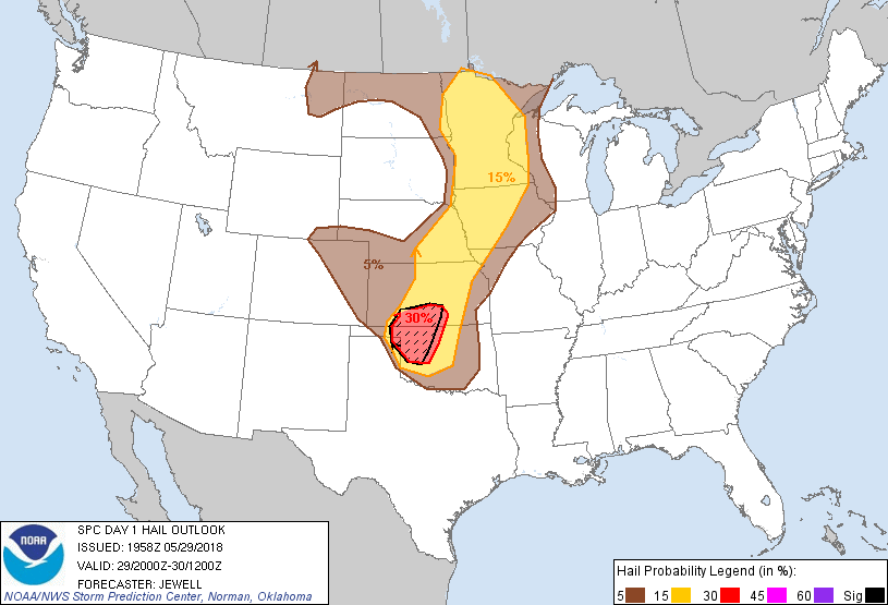
Probabilistic Large Hail Graphic
Probability of hail 1" or larger within 25 miles of a point. Hatched Area: 10% or greater probability of hail 2" or larger within 25 miles of a point.
Day 1 Hail Risk
Area (sq. mi.)
Area Pop.
Some Larger Population Centers in Risk Area
SIG SEVERE
23,623
239,413
Dodge City, KS...Woodward, OK...Elk City, OK...Weatherford, OK...Clinton, OK...
30 %
25,170
686,024
Wichita, KS...Enid, OK...Derby, KS...Woodward, OK...Elk City, OK...
15 %
196,442
11,572,516
Oklahoma City, OK...Omaha, NE...Minneapolis, MN...St. Paul, MN...Lincoln, NE...
5 %
231,040
7,327,062
Kansas City, MO...Tulsa, OK...Overland Park, KS...Kansas City, KS...Sioux Falls, SD...
   SPC AC 291958

   Day 1 Convective Outlook
   NWS Storm Prediction Center Norman OK
   0258 PM CDT Tue May 29 2018

   Valid 292000Z - 301200Z

   ...THERE IS AN ENHANCED RISK OF SEVERE THUNDERSTORMS FROM
   SOUTH-CENTRAL KANSAS INTO NORTHWEST OKLAHOMA...

   ...SUMMARY...
   Severe thunderstorms are expected over parts of the central and
   southern Plains and upper Midwest.  The greatest concentration and
   intensity of threat appears to be from southern Kansas into western
   Oklahoma late this afternoon and evening.

   Little change was made to the previous outlook, except to expand the
   Marginal Risk westward into northeast Montana for wind/hail threat
   within the instability axis.

   ...Southern KS into northwest OK...
   Visible imagery continues to show strong heating over the area with
   a modifying outflow boundary. Early attempts at storms have failed
   due to the cool air near the boundary, but scattered severe cells
   are likely to become established over the next few hours. Steep
   lapse rates aloft, substantial instability and favorably long
   hodographs will favor very large hail in the initial supercells,
   with an increasing threat of wind as cells bow or outflows merge.
   For more information see mesoscale discussion 565.

   ..Jewell.. 05/29/2018

   .PREV DISCUSSION... /ISSUED 1120 AM CDT Tue May 29 2018/

   ...Southern KS/OK...
   Scattered thunderstorms persist this morning across central KS.  The
   associated outflow boundary continues to sag slowly southward across
   far southern KS and into north-central OK.  12z models do not appear
   to have initialized with this boundary, which may significantly
   affect the forecast for later today.  Weak northerly surface winds
   and slightly drier conditions have reduced the confidence of
   significant/widespread severe storms over central KS, so have nudged
   the ENH risk area southward.  Similarly, it appears the risk of
   isolated intense storms may extend slightly farther south into
   western OK, so have expanded the ENH into this region.

   A progressive shortwave trough over northeast NM will move into
   KS/OK this afternoon around peak heating, promoting thunderstorm
   development.  The combination of residual outflow boundaries, steep
   mid level lapse rates, strong CAPE values, and sufficient vertical
   shear, will support a risk of a few supercells over far southern KS
   and northwest OK this afternoon.  These storms will track
   east-southeastward with a risk of very large hail, damaging winds,
   and a few tornadoes.  Some CAM solutions suggest upscale
   organization of a bowing complex that will affect northern/central
   OK this evening, so have extended SLGT risk slightly farther east.

   ...Northern KS into IA/MN...
   Relatively strong cyclonic mid level flow extends from KS
   northeastward across much of IA and MN.  Strong heating is resulting
   in a moderately unstable air mass in this corridor, with all models
   showing the development of multiple waves of scattered afternoon
   thunderstorms.  Sufficient flow aloft will promote organized
   multicell storms capable of hail and damaging winds.

   ...OH/TN valley into AL/SC/GA...
   Alberto continues to track northward across AL, with a large
   envelope of enhanced low-level winds across much of the TN Valley
   and southeast states.  Compared to yesterday, greater cloud cover
   and lower surface dewpoints appear to be negative factors for severe
   wind gusts or tornado risk.  Low-level wind shear also appears
   weaker than previous days.  Therefore will maintain the ongoing MRGL
   risk area with no changes.

   CLICK TO GET WUUS01 PTSDY1 PRODUCT

   NOTE: THE NEXT DAY 1 OUTLOOK IS SCHEDULED BY 0100Z