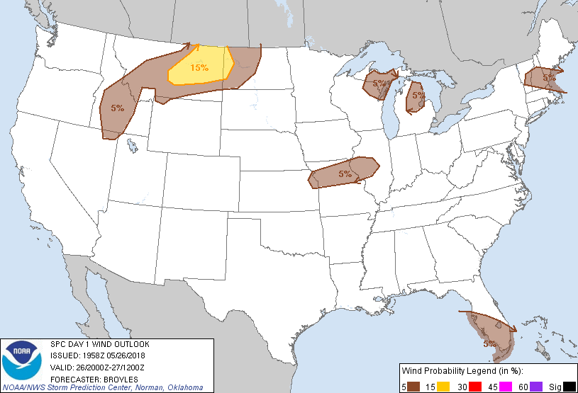
Probability of damaging thunderstorm winds or wind gusts of 50 knots or higher within 25 miles of a point. Hatched Area: 10% of greater probability of wind gusts 65 knots or greater within 25 miles of a point.
Day 1 Wind Risk
Area (sq. mi.)
Area Pop.
Some Larger Population Centers in Risk Area
15 %
47,864
107,353
Williston, ND...Miles City, MT...Lewistown, MT...Glendive, MT...Sidney, MT...
5 %
219,595
17,471,905
Kansas City, MO...Miami, FL...Tampa, FL...St. Petersburg, FL...Hialeah, FL...
Probabilistic Large Hail Graphic
Probability of hail 1" or larger within 25 miles of a point. Hatched Area: 10% or greater probability of hail 2" or larger within 25 miles of a point.
Day 1 Hail Risk
Area (sq. mi.)
Area Pop.
Some Larger Population Centers in Risk Area
15 %
48,030
107,782
Williston, ND...Miles City, MT...Lewistown, MT...Glendive, MT...Sidney, MT...
5 %
156,997
5,017,957
Kansas City, MO...Overland Park, KS...Kansas City, KS...Springfield, IL...Olathe, KS...
   SPC AC 261958

   Day 1 Convective Outlook CORR 1
   NWS Storm Prediction Center Norman OK
   0258 PM CDT Sat May 26 2018

   Valid 262000Z - 271200Z

   ...THERE IS A SLIGHT RISK OF SEVERE THUNDERSTORMS ACROSS PARTS OF
   THE NORTHERN PLAINS AND SOUTH FLORIDA...

   CORRECTED TO INCLUDE THUNDER IN EASTERN IOWA

   ...SUMMARY...
   A severe threat with isolated large hail and wind damage will be
   possible across parts of the northern high Plains late this
   afternoon into the evening. A threat for tornadoes will also be
   possible in parts of south Florida late tonight.

   ...DISCUSSION...
   Two changes have been made to the outlook for this issuance. The
   first change is to add a 5 percent tornado and slight risk area to
   parts of south Florida. The HRRR suggests that rotating storms will
   move inland across south Florida after midnight. RAP forecast
   soundings increase low-level shear throughout the night. Forecast
   hodographs suggest that a tornado threat will be possible with
   semi-discrete rotating cells that move inland in the 06Z to 12Z
   timeframe. The second change is to move the thunder line westward to
   include eastern Iowa where thunderstorms are developing at this
   time.

   ..Broyles.. 05/26/2018

   .PREV DISCUSSION... /ISSUED 1114 AM CDT Sat May 26 2018/

   ...ID/MT/ND...
   A large upper low over CA continues to drift northeastward, with
   strengthening mid level winds and large-scale ascent moving into the
   northern Rockies.  Strong heating is occurring over much of ID/MT,
   with thunderstorms expected to form over the higher terrain by
   mid-afternoon.  These initial storms will pose a threat of locally
   gusty winds and hail.  During the evening, more intense and
   organized storms are expected to form over parts of central/eastern
   MT, tracking into western ND tonight.  The combination of a deep,
   mixed boundary-layer, sufficient CAPE, and relatively strong
   vertical shear profiles support the risk of a few high-based
   supercells capable of large hail and damaging winds.  The activity
   may organize into bowing structures as they move east tonight.

   ...FL...
   Low-level wind profiles around the northeast quadrant of Alberto are
   slowly strengthening, with CAM guidance suggesting shear sufficient
   for rotating cells by later this afternoon along and off the coast
   of southwest FL.  Most model guidance keeps the bulk of the cellular
   convection and stronger wind fields offshore, but there is a MRGL
   chance of an isolated tornado in vicinity of the southwest coast
   through tonight.

   ...WI/MI...
   No changes to forecast have been made to this area.  Scattered
   thunderstorms are expected to form this afternoon over parts of WI
   and MI as an upper trough over MN approaches the region.  The
   strongest cells will be capable of gusty winds and hail, but
   coverage/organization is expected to be low.

   ...MO/IL...
   Clusters of strong/severe afternoon thunderstorms may form today
   over parts of northern MO and central IL.  Strong instability is
   forecast for this area, with MLCAPE values over 3000 J/kg and steep
   low-level lapse rates.  Shear will be relatively weak, promoting
   multicell storm structures with occasional gusty/damaging winds and
   hail.

   ...Central New England...
   A weak surface front extends from northeast NY across parts of VT/NH
   today.  Scattered thunderstorms are expected to form along this
   boundary later today, tracking toward the coast by evening.
   Instability is rather weak, but strong winds aloft, fast storm
   motions, and steep low-level lapse rates will promote a risk of
   gusty winds in the strongest cells.

   CLICK TO GET WUUS01 PTSDY1 PRODUCT

   NOTE: THE NEXT DAY 1 OUTLOOK IS SCHEDULED BY 0100Z