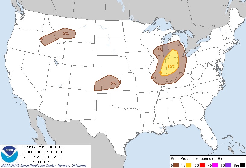
Probability of damaging thunderstorm winds or wind gusts of 50 knots or higher within 25 miles of a point. Hatched Area: 10% of greater probability of wind gusts 65 knots or greater within 25 miles of a point.
   SPC AC 091942

   Day 1 Convective Outlook
   NWS Storm Prediction Center Norman OK
   0242 PM CDT Wed May 09 2018

   Valid 092000Z - 101200Z

   ...THERE IS A SLIGHT RISK OF SEVERE THUNDERSTORMS OVER A PORTION OF
   ILLINOIS...INDIANA AND LOWER MICHIGAN...

   ...SUMMARY...
   Scattered thunderstorms capable of isolated damaging wind and hail
   remain possible across a portion of the Midwest this afternoon and
   evening. Isolated storms with an attendant risk for gusty/damaging
   wind are expected from eastern Colorado into Kansas, and parts of
   the northern Rockies this afternoon and evening.

   ...Discussion...

   Only minor adjustments to account for current trends have been made
   to previous outlook. Scattered, primarily multicell thunderstorms
   are expected to develop along cold front from southern WI into IL
   this afternoon. Some of the storms may produce a few instances of
   locally strong to damaging wind gusts and hail through early
   evening. Elsewhere high based storms might produce isolated
   downburst winds from eastern CO into KS and from ID into western MT.

   ..Dial.. 05/09/2018

   .PREV DISCUSSION... /ISSUED 1109 AM CDT Wed May 09 2018/

   ...Midwest...
   Only minor changes have been made to the ongoing forecast.  The
   primary convectively-aided vorticity max over WI will track
   northeastward and away from the risk area, allowing surface heating
   to begin across IL/IN as the associated cloud/precipitation shield
   diminishes.  Most 12z CAM solutions indicate the re-development of
   scattered thunderstorms this afternoon over IL, spreading eastward
   into Lower MI and IN through the evening.  Forecast soundings
   suggest some potential for a few storms to become organized,
   producing locally damaging wind gusts or hail.  An isolated tornado
   is possible over the northern half of the risk area this afternoon
   where low level shear profiles are slightly more favorable.

   ...KS/CO...
   Weak large scale ascent is spreading across the central Rockies, and
   will move into the adjacent High Plains later this afternoon.  A
   combination of deep boundary-layer mixing and sufficient CAPE will
   result in a few high-based showers and thunderstorms over southeast
   CO and western KS this afternoon and evening.  The strongest of
   these cells could produce gusty/damaging wind gusts.

   ...ID/MT...
   Have added a MRGL risk area to portions of the northern Rockies.
   Strong heating is occurring in most of this region this morning as
   the upper ridge slowly weakens and an upper trough over the Pacific
   Northwest approaches.  Scattered thunderstorms are expected to
   develop across this region later today, spreading as far east as
   central MT this evening.  Forecast soundings show mid level winds
   strengthening through the day, suggesting the potential for a few
   stronger gusts mixing to the surface.

   CLICK TO GET WUUS01 PTSDY1 PRODUCT

   NOTE: THE NEXT DAY 1 OUTLOOK IS SCHEDULED BY 0100Z