Greensboro, NC...Springfield, MO...Fayetteville, NC...High Point, NC...Suffolk, VA...
Probabilistic Tornado Graphic
Probability of a tornado within 25 miles of a point. Hatched Area: 10% or greater probability of EF2 - EF5 tornadoes within 25 miles of a point.
Day 1 Tornado Risk
Area (sq. mi.)
Area Pop.
Some Larger Population Centers in Risk Area
No Risk Areas Forecast
Probabilistic Damaging Wind Graphic
Probability of damaging thunderstorm winds or wind gusts of 50 knots or higher within 25 miles of a point. Hatched Area: 10% of greater probability of wind gusts 65 knots or greater within 25 miles of a point.
Greensboro, NC...Springfield, MO...Fayetteville, NC...High Point, NC...Jacksonville, NC...
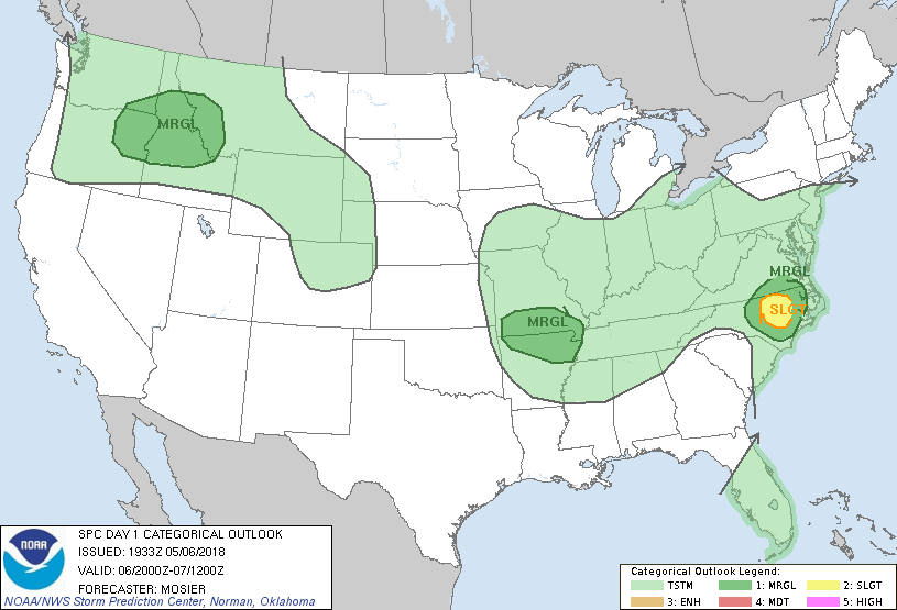
   SPC AC 061933

   Day 1 Convective Outlook
   NWS Storm Prediction Center Norman OK
   0233 PM CDT Sun May 06 2018

   Valid 062000Z - 071200Z

   ...THERE IS A SLIGHT RISK OF SEVERE THUNDERSTORMS OVER A PORTION OF
   EASTERN NC...

   ...SUMMARY...
   Isolated severe storms with hail and wind are possible late
   afternoon to mid-evening over central/eastern North Carolina and far
   southeast Virginia, the interior Northwest and northern Rockies, as
   well as southern Missouri and northern Arkansas.

   ...20Z Update...
   Highest likelihood of severe storms still appears to be across
   portions of central and eastern NC where storms have developed in an
   airmass characterized by 500-1000 J/kg of MLCAPE and effective shear
   around 40 to 50 kt. Forecast reasoning outlined in the previous
   outlook (appended below) and MCD 362 remains valid with no change
   needed to the outlook over this area.

   Farther west, isolated severe storms remain possible across southern
   MO and northern AR as a shortwave trough moves through the region
   this afternoon and evening. Additionally, thunderstorm coverage will
   gradually increase across the interior Pacific Northwest and
   adjacent northern Rockies as forcing for ascent increases and
   daytime heating promote airmass destabilization. Marginally severe
   hail and isolated damaging wind gusts are also possible with the
   strongest storms. No changes were needed with Marginal areas over
   either region.

   ..Mosier.. 05/06/2018

   .PREV DISCUSSION... /ISSUED 1129 AM CDT Sun May 06 2018/

   ...Central/eastern NC and far southeast VA...
   A shortwave trough over the central Appalachians will decay as it
   progresses towards the Northeast states. A weak surface cyclone near
   Greensboro should track east along the NC/VA border through this
   evening. A narrow wedge of robust insolation is underway near the
   surface cyclone, between the impinging cold front and widespread
   cloud/stratiform rain across eastern portions of NC/VA. Weak
   mid-level lapse rates sampled by 12Z soundings will limit updraft
   acceleration this afternoon, but the corridor of surface heating
   amid residual mid 60s surface dew points should yield MLCAPE of
   500-1000 J/kg. Isolated to scattered storm development is likely by
   mid-late afternoon. J-shaped hodographs will favor strong vertical
   shear within the mid to upper portion of the thermodynamic profile
   which should support a few supercells. Isolated to widely scattered
   severe hail and damaging wind gusts will be possible, before
   weakening after sunset.

   ...Southern MO/northern AR...
   A series of subtle mid-upper speed maxima will move from the central
   Great Plains to the Lower MS Valley atop a diffuse confluence
   boundary that should sag into central OK to southern MO. Though
   boundary-layer moisture is marginal, surface dew points in the lower
   50s in conjunction with strong surface heating will promote
   inverted-v thermodynamic profiles. Steep lapse rates above the
   inverted-v will contribute to MLCAPE from 500-1000 J/kg in the late
   afternoon. Isolated high-based storms should form by early evening
   and likely evolve into a small multicell cluster or two given
   effective shear of 20-30 kt. Isolated severe hail and damaging wind
   gusts will be the main hazards, before storms diminish after sunset.

   ...Interior Northwest/Northern Rockies...
   A compact shortwave trough over the northern Sierra Nevada will
   dampen as it reaches the northern Rockies tonight. Large-scale
   ascent accompanying this feature will foster storm development from
   eastern OR into western ID during the late afternoon. Though
   low-level moisture will be limited, rather steep low to mid-level
   lapse rates will support MLCAPE around 500 J/kg at peak heating.
   Multicell clusters are expected to develop/spread northeast across
   northern ID into western MT through mid-evening. Isolated severe
   wind gusts, as well as marginally severe hail will be possible until
   storms weaken by late evening.

   CLICK TO GET WUUS01 PTSDY1 PRODUCT

   NOTE: THE NEXT DAY 1 OUTLOOK IS SCHEDULED BY 0100Z