New York, NY...Columbus, OH...Virginia Beach, VA...Pittsburgh, PA...Cincinnati, OH...
SPC AC 270828
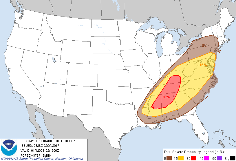
Day 3 Convective Outlook
NWS Storm Prediction Center Norman OK
0228 AM CST Mon Feb 27 2017
Valid 011200Z - 021200Z
...THERE IS AN ENHANCED RISK OF SEVERE THUNDERSTORMS FOR PARTS OF
MISSISSIPPI...ALABAMA...AND NORTHWESTERN GEORGIA INTO MIDDLE AND
EASTERN TENNESSEE AND CENTRAL AND SOUTHEASTERN KENTUCKY...
...THERE IS A SLIGHT RISK OF SEVERE THUNDERSTORMS FROM THE LOWER
MISSISSIPPI VALLEY THROUGH PARTS OF THE SOUTHERN AND CENTRAL
APPALACHIAN STATES AND INTO THE MID-ATLANTIC STATES...
...THERE IS A MARGINAL RISK OF SEVERE THUNDERSTORMS FROM THE CENTRAL
GULF COAST NORTHEASTWARD INTO PORTIONS OF THE NORTHEAST...
...SUMMARY...
Strong to severe thunderstorms will be possible from the lower
Mississippi Valley northeastward across the Tennessee Valley and
southern Appalachians, and northward into parts of the Mid-Atlantic
states and perhaps portions of the Northeast.
...Synopsis...
A mid-level trough will move eastward across the Midwest and into
the lower Great Lakes during the day-3 period. The primary
mid-level vorticity maximum is progged to move from the middle MS
Valley east-northeastward into the lower Great Lakes by late
afternoon/early evening. A surface low will develop northeast from
Ontario to the St. Lawrence Seaway by late Wednesday night. A cold
front, initially near the lower OH Valley and lower MS Valley, will
sweep eastward across much of the Southeast and the East.
...lower MS Valley into the TN Valley and southern Appalachians and
north into the Mid-Atlantic states...
An ongoing and likely extensive squall line or broken bands of
storms are forecast near the MS River and lower OH Valley in
association with a cold front. Models vary slightly on the timing
of the fronts' position during the early part of the day. However,
it seems likely substantial low-level moisture (upper 50s-mid 60s
dewpoints) will extend northeast from the lower MS Valley to the
WV/KY/OH/VA vicinity. Despite the prevalence of some mid-high cloud
cover, very strong low- to mid-tropospheric winds (50-70 kt
southwesterly flow at 700 mb) should aid in the development of
squall line with LEWPS/bowing segments capable of wind damage and
possibly a tornado where greater destabilization occurs. The
convective line will likely persist (owing to 60-90m 12 hour 500mb
height falls) and move across the Appalachian spine and possibly
yield a continued risk for damaging winds after dark despite the
loss of daytime heating. The diminishing of buoyancy with eastward
extend across the Southeast U.S. will probably lead to a
corresponding weakening in storm intensity and strong/severe storm
coverage.
...lower Great Lakes and Hudson Valley...
The northern periphery of appreciable low-level moisture will likely
move into the area as a warm front advances northward through a
large part of the Northeast. A storm cluster or two may be ongoing
early Wednesday and may delay destabilization. However, an influx
of mid-upper 50s dewpoints will likely result in several hundred
J/kg MUCAPE with a strong wind profile indicative of organized storm
structures. One or more bands may develop or move into the area
during the midday/afternoon as the effective front pushes eastward.
Damaging winds will probably be the main severe hazard. The main
limiting factor for higher coverage of strong to severe
thunderstorms will be weak instability.
..Smith.. 02/27/2017
CLICK TO GET WUUS03 PTSDY3 PRODUCT
NOTE: THE NEXT DAY 3 OUTLOOK IS SCHEDULED BY 0830Z