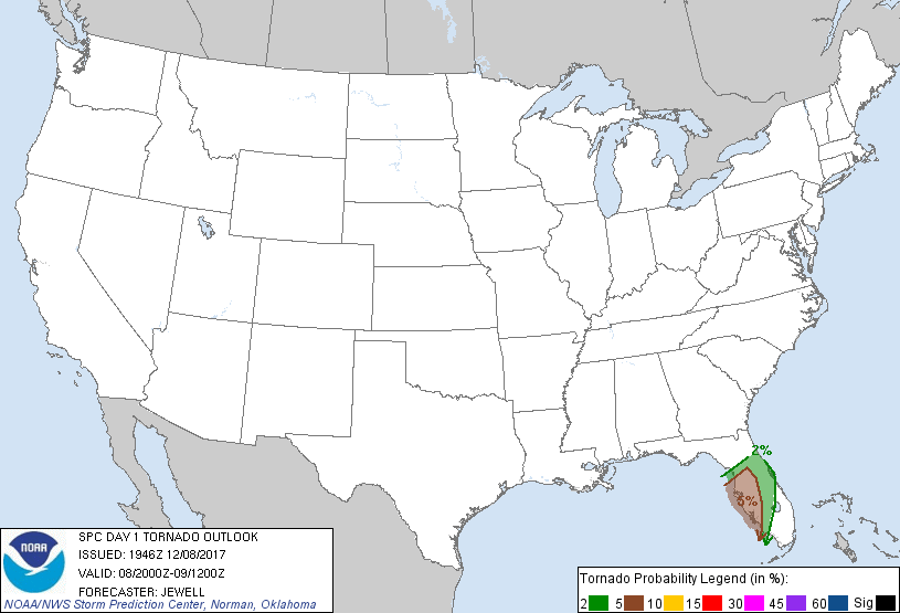
Palm Bay, FL...Melbourne, FL...Daytona Beach, FL...Port Orange, FL...Ocala, FL...
Probabilistic Tornado Graphic
Probability of a tornado within 25 miles of a point. Hatched Area: 10% or greater probability of EF2 - EF5 tornadoes within 25 miles of a point.
Day 1 Tornado Risk
Area (sq. mi.)
Area Pop.
Some Larger Population Centers in Risk Area
5 %
11,653
5,522,479
Tampa, FL...St. Petersburg, FL...Cape Coral, FL...Clearwater, FL...Spring Hill, FL...
2 %
13,480
3,656,575
Orlando, FL...Deltona, FL...Melbourne, FL...Daytona Beach, FL...Kissimmee, FL...
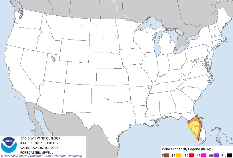
Probabilistic Damaging Wind Graphic
Probability of damaging thunderstorm winds or wind gusts of 50 knots or higher within 25 miles of a point. Hatched Area: 10% of greater probability of wind gusts 65 knots or greater within 25 miles of a point.
Palm Bay, FL...Melbourne, FL...Daytona Beach, FL...Port Orange, FL...Ocala, FL...
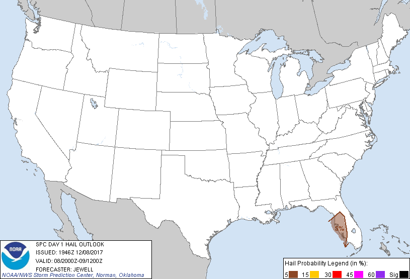
Probabilistic Large Hail Graphic
Probability of hail 1" or larger within 25 miles of a point. Hatched Area: 10% or greater probability of hail 2" or larger within 25 miles of a point.
Day 1 Hail Risk
Area (sq. mi.)
Area Pop.
Some Larger Population Centers in Risk Area
5 %
11,683
5,409,269
Tampa, FL...St. Petersburg, FL...Cape Coral, FL...Clearwater, FL...Spring Hill, FL...
SPC AC 081946
Day 1 Convective Outlook
NWS Storm Prediction Center Norman OK
0146 PM CST Fri Dec 08 2017
Valid 082000Z - 091200Z
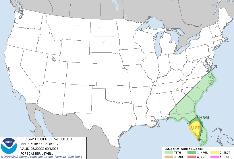
...THERE IS A SLIGHT RISK OF SEVERE THUNDERSTORMS ACROSS THE CENTRAL
AND WESTERN FLORIDA PENINSULA...
...THERE IS A MARGINAL RISK OF SEVERE THUNDERSTORMS ACROSS MUCH OF
THE FLORIDA PENINSULA...
...SUMMARY...
Isolated severe thunderstorms capable of a tornado or two and/or
damaging winds are expected across parts of the Florida Peninsula
this evening and overnight.
...Florida...
No changes were made to the previous outlook, as the storm threat is
expected to increase this evening and overnight. Isolated storms
ahead of the front may affect the west coast this evening with brief
tornado or wind threat, with the main squall line expected later
tonight.
..Jewell.. 12/08/2017
.PREV DISCUSSION... /ISSUED 1018 AM CST Fri Dec 08 2017/
...FL...
No significant changes have been made to the ongoing severe
thunderstorm forecast. 12z CAM solutions continue to indicate that
scattered thunderstorms will spread inland into the central FL
peninsula along/ahead of an approaching cold front. The risk may
develop by late this afternoon, but consensus of solutions suggests
the risk is greater after dark and through the night. Forecast
soundings show a moist/unstable low-level air mass, along with
sufficient low-level and deep-layer vertical shear to promote
rotating storms and bowing structures. Several models also promote
discrete convection ahead of the front, which would also contribute
to the risk of a tornado or two and locally damaging wind gusts.
The threat of severe storms will likely focus over the western
peninsula, with a decreasing risk as storms proceed eastward late
tonight.
CLICK TO GET WUUS01 PTSDY1 PRODUCT
NOTE: THE NEXT DAY 1 OUTLOOK IS SCHEDULED BY 0100Z