Probability of damaging thunderstorm winds or wind gusts of 50 knots or higher within 25 miles of a point. Hatched Area: 10% of greater probability of wind gusts 65 knots or greater within 25 miles of a point.
Probability of hail 1" or larger within 25 miles of a point. Hatched Area: 10% or greater probability of hail 2" or larger within 25 miles of a point.
Day 1 Hail Risk
Area (sq. mi.)
Area Pop.
Some Larger Population Centers in Risk Area
15 %
34,593
176,518
Rapid City, SD...Rapid Valley, SD...Sturgis, SD...
5 %
127,330
2,633,503
Omaha, NE...Lincoln, NE...Council Bluffs, IA...Ames, IA...West Des Moines, IA...
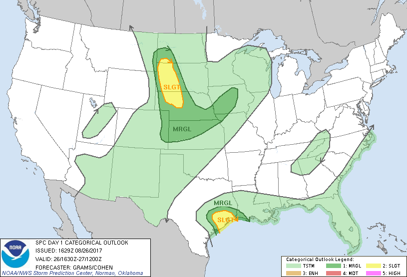
   SPC AC 261629

   Day 1 Convective Outlook
   NWS Storm Prediction Center Norman OK
   1129 AM CDT Sat Aug 26 2017

   Valid 261630Z - 271200Z

   ...THERE IS A SLIGHT RISK OF SEVERE THUNDERSTORMS UPPER TX GULF
   COAST...

   ...THERE IS A SLIGHT RISK OF SEVERE THUNDERSTORMS WESTERN SD AND
   NORTHERN NE...

   ...THERE IS A MARGINAL RISK OF SEVERE THUNDERSTORMS UPPER TX GULF
   COAST AND FAR SOUTHWEST LA...

   ...THERE IS A MARGINAL RISK OF SEVERE THUNDERSTORMS NORTHERN/CENTRAL
   GREAT PLAINS TO IA...

   ...SUMMARY...
   A few tornadoes are possible over the Upper Texas Coastal Plain
   through early Sunday. Widely scattered large hail and severe wind
   storms are possible across western South Dakota into northern
   Nebraska late afternoon and evening.

   ...Western Gulf Coastal Plain...
   At least a low-end tornado threat should continue through the period
   within persistent outer bands of TC Harvey, on the periphery of
   sufficient low-level shear for transient mesocyclones. This risk may
   increase late afternoon into evening if weak diabatic heating can
   persist amid thinner cloud coverage between the ongoing outer band
   over the Upper TX Coastal Plain and the inner stratiform core over
   the Middle TX Coastal Plain. Should this occur within more favorably
   enlarged low-level hodographs, a secondary wave of transient
   supercell structures may develop within a relatively confined
   corridor of the Upper TX Coastal Plain. Refer to MCD 1573 for
   additional short-term information.

   ...Western SD to northern NE...
   Downstream of a subtle mid-level impulse across eastern MT/far
   western ND, robust diabatic heating is underway which should yield
   MLCAPE of 1000-2000 J/kg amid surface dew points mixing into the 50s
   by late afternoon. Widely scattered storm development should occur
   in this time frame. Veering of the wind profile with height
   augmented by moderately fast mid/upper-level west-northwesterlies
   will foster a few supercells with large hail as the initial primary
   hazard. These may congeal into a southeast-moving cluster into parts
   of northern NE with a mixed risk of severe wind/hail before
   gradually waning tonight.

   ...IA to central High Plains...
   More isolated coverage of severe wind and hail is anticipated along
   a weak cold front that should become quasi-stationary. The greatest
   low-level convergence should occur across the Mid-MO Valley portion
   of the boundary aided by a shortwave impulse drifting across the
   Upper MS Valley. This should be sufficient to overcome MLCIN and
   yield widely scattered storms late afternoon to mid-evening. Modest
   veering of the wind profile with height could support a short-lived
   cluster with isolated severe hail/wind.

   ..Grams/Cohen.. 08/26/2017

   CLICK TO GET WUUS01 PTSDY1 PRODUCT

   NOTE: THE NEXT DAY 1 OUTLOOK IS SCHEDULED BY 2000Z