New York, NY...Philadelphia, PA...Columbus, OH...Baltimore, MD...Charlotte, NC...
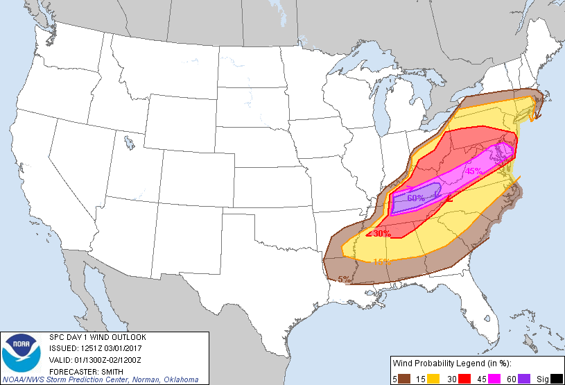
Probabilistic Damaging Wind Graphic
Probability of damaging thunderstorm winds or wind gusts of 50 knots or higher within 25 miles of a point. Hatched Area: 10% of greater probability of wind gusts 65 knots or greater within 25 miles of a point.
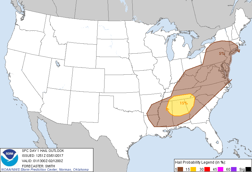
Probability of hail 1" or larger within 25 miles of a point. Hatched Area: 10% or greater probability of hail 2" or larger within 25 miles of a point.
Day 1 Hail Risk
Area (sq. mi.)
Area Pop.
Some Larger Population Centers in Risk Area
15 %
61,907
10,679,948
Atlanta, GA...Birmingham, AL...Huntsville, AL...Chattanooga, TN...Sandy Springs, GA...
5 %
389,964
86,288,131
New York, NY...Philadelphia, PA...Memphis, TN...Baltimore, MD...Charlotte, NC...
SPC AC 011251
Day 1 Convective Outlook
NWS Storm Prediction Center Norman OK
0651 AM CST Wed Mar 01 2017
Valid 011300Z - 021200Z
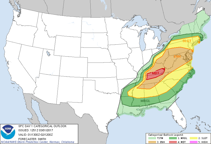
...THERE IS A MODERATE RISK OF SEVERE THUNDERSTORMS FROM CENTRAL
KENTUCKY AND MIDDLE TENNESSEE INTO THE CUMBERLAND GAP...
...THERE IS AN ENHANCED RISK OF SEVERE THUNDERSTORMS FROM PORTIONS
OF THE TENNESSEE VALLEY INTO THE CENTRAL APPALACHIANS AND
MID-ATLANTIC STATES...
...THERE IS A SLIGHT RISK OF SEVERE THUNDERSTORMS ACROSS PARTS OF
MISSISSIPPI EASTWARD INTO THE CAROLINA PIEDMONT AND INTO PARTS OF
THE NORTHEAST...
...THERE IS A MARGINAL RISK OF SEVERE THUNDERSTORMS SURROUNDING THE
SLIGHT RISK...
...SUMMARY...
Widespread wind damage is forecast across parts of Kentucky and
Tennessee this morning. Severe thunderstorms will continue to
spread across the Ohio and Tennessee Valley regions into the Middle
Atlantic states, possibly into southern New England by mid
afternoon. Damaging winds are the primary severe threat, though a
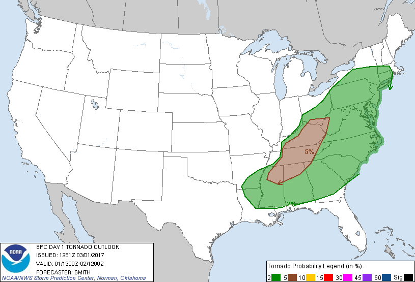
few tornadoes and hail will be possible, especially west of the
Appalachians.
...KY-TN eastward into the Mid-Atlantic states...
Radar imagery early this morning shows an extensive squall line from
the upper OH Valley southwestward into portions of west-central KY
and middle TN. The southern portion of the squall line has had a
several-hour history of widespread measured severe gusts as it
tracked from eastern AR into western KY/TN. A MCV associated with
this part of the line is forecast to move downstream within a belt
of 80-90 kt 500-mb flow. It seems likely the greatest concentration
of severe gusts and swaths of wind damage will align from near the
I-65 corridor in TN/KY to the spine of the Appalachians by late this
morning (16z)---resulting in higher wind probabilities and a
moderate risk. It appears increasingly likely destabilization will
not be inhibited by prior storm activity from the southern half of
WV east-northeastward into the D.C and DelMarVa areas. CAM
guidance, in particular the 01/00z NSSL WRF, appears to have a
relatively good depiction of the evolving convective lines through
12z this morning. Storm-scale guidance moves a squall line into the
I-95 corridor during the early afternoon (roughly 18-21z) coincident
with appreciable diurnal destabilization and steepening of low-level
lapse rates and becoming more favorable for momentum transfer. In
addition to the risk for widespread damaging winds, the
stronger/longer-lived mesovortices embedded within the line may
yield a weak tornado risk.
In wake of the early-day squall line over TN, additional storm
development is possible across the TN Valley south of where
convective overturning and significant stabilization has occurred.
The strong wind profile will strongly favor storm organization.
Hail, wind, and possibly some tornado risk could develop before
upscale growth occurs across AL/GA with isolated damaging winds
becoming the primary threat towards evening.
...northern half of PA into NY and southern New England...
Destabilization this morning will likely be hindered appreciably as
widespread cloud cover stunts surface heating. As the northern
portions of the squall line over northwestern PA and the upper OH
Valley pushes eastward this morning, a corresponding risk for strong
to possibly severe gusts may accompany the line.
..Smith.. 03/01/2017
CLICK TO GET WUUS01 PTSDY1 PRODUCT
NOTE: THE NEXT DAY 1 OUTLOOK IS SCHEDULED BY 1630Z