San Antonio, TX...Austin, TX...Round Rock, TX...College Station, TX...Bryan, TX...
Probabilistic Damaging Wind Graphic
Probability of damaging thunderstorm winds or wind gusts of 50 knots or higher within 25 miles of a point. Hatched Area: 10% of greater probability of wind gusts 65 knots or greater within 25 miles of a point.
San Antonio, TX...Dallas, TX...Austin, TX...Fort Worth, TX...Arlington, TX...
SPC AC 151958
Day 1 Convective Outlook
NWS Storm Prediction Center Norman OK
0158 PM CST Sun Jan 15 2017
Valid 152000Z - 161200Z
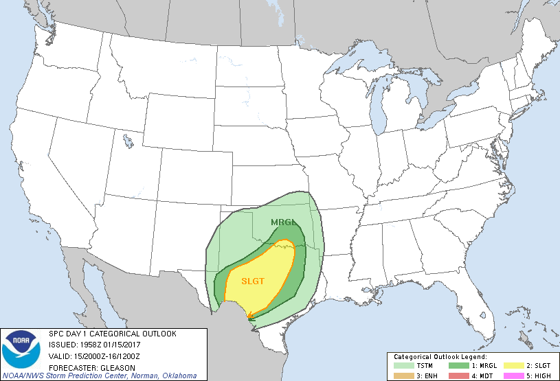
...THERE IS A SLIGHT RISK OF SEVERE THUNDERSTORMS ACROSS MUCH OF
WEST-CENTRAL/NORTH-CENTRAL TX TO FAR SOUTHERN OK...
...THERE IS A MARGINAL RISK OF SEVERE THUNDERSTORMS ACROSS THE
SOUTHERN PLAINS...
...SUMMARY...
Scattered severe thunderstorms will be possible this afternoon and
tonight across west-central to north-central Texas and southern
Oklahoma. A few tornadoes, damaging winds, and large hail are
anticipated.
...20Z Update...
The severe threat across southwest into west TX is expected to
continue increasing through the afternoon. The only change to the
prior outlook across this area has been to account for the eastward
movement of the cold front and line of pre-frontal convection. The
northern extent of the appreciable severe risk remains confined by a
shallow cold and stable airmass over the TX Panhandle into southwest
OK. For more near-term meteorological details (through ~2130Z) on
the developing severe risk across southwest TX, see Mesoscale
Discussion 52.
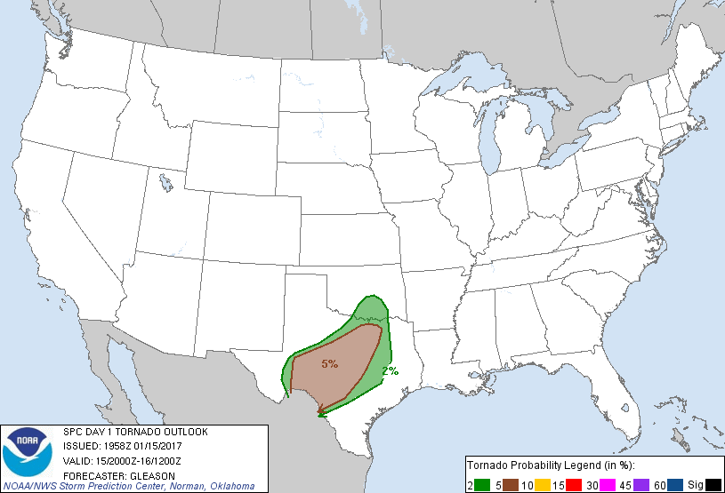
There is some concern that isolated showers and thunderstorms
ongoing over parts of east TX in a warm air advection regime may
become surface based this afternoon and evening. Low to mid 60s
surface dewpoints across this region will continue to shift
northward into the Metroplex over the next few hours as a warm front
lifts northward. RAP/HRRR forecast soundings suggest that an
isolated tornado threat may develop with pre-frontal warm sector
convection as a low-level jet strengthens across central/north TX in
the 00-03Z timeframe. Have accordingly made a minor adjustment to
the 5% tornado probabilities in/around the Metroplex to account for
this scenario.
..Gleason.. 01/15/2017
.PREV DISCUSSION... /ISSUED 1030 AM CST Sun Jan 15 2017/
...Portions of Texas into southern Oklahoma...
Mid/late morning water vapor satellite imagery shows an
east/northeastward-moving upper low nearing the El Paso/far west TX
vicinity. This low will continue northeastward and increasingly take
on a negative tilt over the southern High Plains. Ahead of this
system, 30-45 kt southerly low-level winds (1-3 km above ground
level) will continue to transport a seasonally moist air mass
northward, with lower 60s F surface dewpoints expected to reach
parts of north-central/northeast TX late today, while some middle
60s F surface dewpoints will reach parts of south-central TX/Hill
Country. Persistent low clouds and continued convection to the north
of a warm front cast some uncertainty on the exact degree of
destabilization later today, particularly with northward extent into
north-central TX and far southern OK.
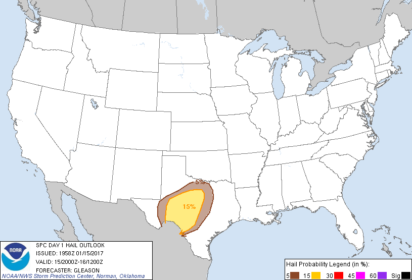
Current thinking is that increasingly strong thunderstorms should
develop by around mid-afternoon initially across southwest TX in
vicinity of the Permian Basin and western Edwards Plateau. The most
numerous storms through early evening should occur near the
eastward-advancing front across west-central TX. However, sufficient
low-level moisture and modest capping may allow for some
front-preceding surface-based storms to develop late this
afternoon/early evening across the Edwards Plateau/Hill Country
vicinities toward the I-35 corridor of north-central Texas. Given
that deep-layer/low-level shear will be increasing through early
evening, both initial semi-discrete/line-embedded supercells will be
possible ahead of an increasingly prominent linear mode near the
cold front this evening. Bouts of large hail will be possible
especially with initial development across west TX this afternoon,
but damaging winds and isolated tornadoes should become the primary
risks into this evening across a large part of
west-central/north-central TX.
CLICK TO GET WUUS01 PTSDY1 PRODUCT
NOTE: THE NEXT DAY 1 OUTLOOK IS SCHEDULED BY 0100Z